Plym Valley Trail
![]()
![]() This shared cycling and walking trail follows the old Plym Valley railway from Clearbrook to Saltram Park. The trail runs for a distance of about 7 miles along a fairly flat, traffic free path. Along the way there's nice views of the River Plym and the countryside of Bickleigh Vale.
This shared cycling and walking trail follows the old Plym Valley railway from Clearbrook to Saltram Park. The trail runs for a distance of about 7 miles along a fairly flat, traffic free path. Along the way there's nice views of the River Plym and the countryside of Bickleigh Vale.
This route starts at the northern end of the trail at Clearbrook where parking is available. You then head south towards Bickleigh and Plymbridge Woods. The attractive woods have a nice family cycle trail with a series of viaducts, a disused railway station and pretty bridges over the river. The area also includes Cann Woods where there's some good mountain bike trails and miles of woodland trails. In this area there's also the Cann Viaduct where you can look out for the Peregrine Falcons from the elevated spot.
The route continues past Leigham and Marsh Mills station to the finish point at the National Trust's Saltram Park. In the park National Cycle Route 27 runs along a splendid traffic free trail through Saltram Wood and along the River Plym. There's also lots of walking trails to explore 500 acres of woodland, farmland, beaches, saltmarshes, meadows and river estuary. You can extend the route by continuing south and then west to visit the city of Plymouth.
Plym Valley Trail Ordnance Survey Map  - view and print off detailed OS map
Plym Valley Trail Open Street Map  - view and print off detailed map
*New* - Walks and Cycle Routes Near Me Map - Waymarked Routes and Mountain Bike Trails>>
Plym Valley Trail OS Map  - Mobile GPS OS Map with Location tracking
Plym Valley Trail Open Street Map  - Mobile GPS Map with Location tracking
Pubs/Cafes
At one end of the route at Clearbrook there's the Skylark Inn for some refreshment. They serve good quality food and have a lovely garden area to relax in. You can find them at postcode PL20 6JD for your sat navs.
At the other end of the route there's a decent National Trust cafe at Saltram House.
Further Information and Other Local Ideas
The 22 mile Drakes Trail uses part of the trail. It starts in Tavistock and visits the Tavistock Canal and Grenofen Bridge before linking up with the trail. The route is named after the explorer Sir Francis Drake who was born in Tavistock and has a statue in Plymouth.
Cycle Routes and Walking Routes Nearby
Photos
Near the start/end at Marsh Mills. A yacht works is on one side (behind the razor wire) and the terminus of the Plym Valley Railway on the other.
Saltram House at the end of the route. The grade I listed George II era mansion house located in the parish of Plympton. It was deemed by the architectural critic Pevsner to be "the most impressive country house in Devon". Saltram is one of Britain's best preserved examples of an early Georgian house and retains much of its original decor, plasterwork and furnishings. The house was used as one of several local settings for the 1995 film Sense and Sensibility.
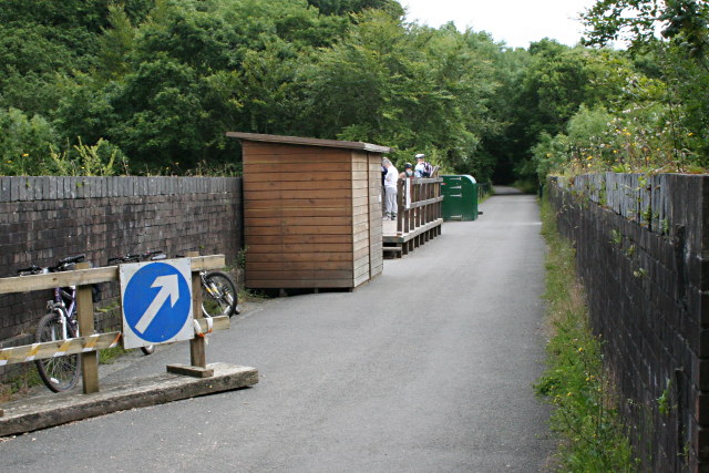
Viewing Platform on Cann Viaduct. The viaduct on the disused railway line, now part of the Plym Valley Cycleway, makes an ideal view point for Peregrine Falcons which in recent years have been nesting on ledges on the disused quarry face opposite. Instead of trying to keep the nesting site a secret, the location was advertised, a web-cam set up and viewing encouraged, a tactic which seems to have been successful in protecting the birds from egg collectors and poisoners.
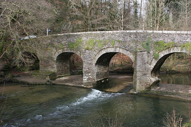
Plym Bridge. This old bridge over the river Plym is an access point to the recreational area of the Plym valley woodlands. The bridge used to be the lowest crossing on the river. It is now closed to motor vehicles to avoid this route being used as a rat run. Car parks at either side of the bridge give access to visitors.


