Alford Walks
![]()
![]() This small market town is located in a lovely spot on the edge of the Lincolnshire Wolds AONB. The town is noted for the splendid Alford Manor House, a 13th century church and the five sailed Alford Windmill.
This small market town is located in a lovely spot on the edge of the Lincolnshire Wolds AONB. The town is noted for the splendid Alford Manor House, a 13th century church and the five sailed Alford Windmill.
This circular walk from the town takes you east to the neighbouring village of Bilsby. It also passes the Alford Windmill, a local tourist attraction.
The walk starts in the town centre near the market place and church. You can follow country lanes east through the countryside to Bilsby where there's a noteworthy 15 century church to see.
The walk then returns to Alford on a footpath heading west. This passes close to the windmill which has been restored to working order, and grinds grain to organic flour. From here it is a short stroll back into the town centre.
Postcode
LN13 9DS - Please note: Postcode may be approximate for some rural locationsAlford Ordnance Survey Map  - view and print off detailed OS map
Alford Open Street Map  - view and print off detailed map
Alford OS Map  - Mobile GPS OS Map with Location tracking
Alford Open Street Map  - Mobile GPS Map with Location tracking
Pubs/Cafes
The George Inn is a good choice for some post walk refreshment. It's located next to the ancient St Wilfred’s Church and dates back to the 18th century. They do a lovely carvery and also have a garden area to sit out in. You can find them on the High Street at postcode LN13 9DS.
Dog Walking
The country trails are nice to walk with your dog and the George Inn mentioned above is also dog friendly.
Further Information and Other Local Ideas
Head west to South Ormesby and you can pick up the epic Lindsey Trail. This circular cycling and walking trail explores the Lincolnshire Wolds AONB on a bridleway path.
Just to the south west you'll find Snipe Dales Country Park. There's miles of heathland and woodland trails to follow around this 220 acre site. It's also a nature reserve so there's good wildlife spotting opportunities too. Near here you'll find the villages of Hagworthingham and Winceby, where there's the site of a civil war battlefield.
The town is located not far from the coast where you can visit the popular towns of Skegness, Chapel St Leonards and Mablethorpe. This pleasant town has a lovely promenade and some attractive coastal gardens to visit.
To the west there's the worthy village of Donington on Bain. Here you'll find a 12th century church, a fine 18th century pub and nice views of the River Bain. Near here there's also Binbrook, Biscathorpe and East Wykeham where there are the sites of two deserted medieval villages to explore.
A few miles to the south there's the noteworthy Gunby Hall. The historic hall is one of the area highlights with 8 acres of beautiful gardens, an 18th century manor and an expansive country estate to explore.
For more walking ideas in the area see the Lincolnshire Walks page.
Cycle Routes and Walking Routes Nearby
Photos
Alford Manor House. This Grade II* listed building can be found on West street near the town centre. It is thought to be the largest thatched manor house in England and was built to a traditional H plan in 1611. The house is one of the highlights of the town and includes a museum, exhibits and several of Alford's historic artifacts. It's also a nice place for an easy stroll with pretty gardens and a tea room for refreshment afterwards. You can find them on West Street at postcode LN13 9HT for your sat navs.
St.Wilfrid's from the Market Place. View through south Market Place to St.Wilfrid's church. The church is well worth a visit, dating all the way back to the 13th century. Features of the church include a 14th-century rood screen dividing the chancel from the nave, a Jacobean pulpit, traces of 16th-century glass within the stained glass windows, and a 17th-century tomb within the chancel.
Queen Victoria memorial fountain. Marble drinking fountain in Alford Market Place, erected after the death of Queen Victoria in 1901
Alford Windmill. This five-sailed windmill has been restored, and grinds organic flour. It is open as a tourist attraction. The last commercial operators of the windmill were the Hoyles family. Purchased by Harry Hoyles, a local farmer and land owner, in the early 20th Century, the business of milling and baking continued until the mid 1950s, run by his sons Walter, Arthur and Winston (The Miller). The business closed due to advancements in technology and the mill was initially sold to a private buyer, but was eventually bought by the Lincolnshire County Council.
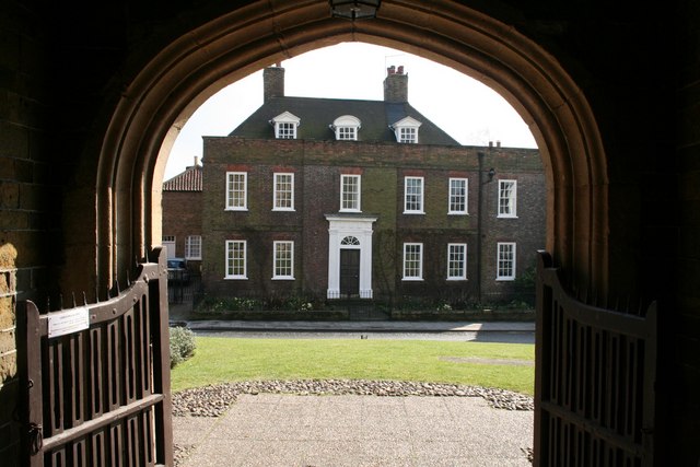
Hanby Hall, located near the town centre in Alford. Grade II* listed early 18th century house built for Sir Richard Hanby, seen from St. Wilfrid's church porch


