Baslow Walks
![]()
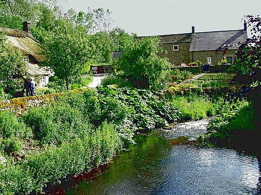
![]() The pretty Peak District village of Baslow gives access to a number of great walking routes. The popular village sits on the River Derwent which is spanned by a 17th-century bridge. There's also a pretty village green and nice pubs and cafes for refreshments.
The pretty Peak District village of Baslow gives access to a number of great walking routes. The popular village sits on the River Derwent which is spanned by a 17th-century bridge. There's also a pretty village green and nice pubs and cafes for refreshments.
This circular walk visits Baslow Edge, Curbar Edge and Froggatt Edge before returning to the village along the River Derwent. There's great views from over the moors from Curbar Edge and interesting geological features. Along the river there's weirs, mills and the villages of Grindleford and Calver.
Other Walks around Baslow
- Birchen Edge - Climb to this gritstone edge and enjoy wonderful views over the Derwent Valley in the Peak District. You can start the walk from the Robin Hood pub car park just to the south of Birchen Edge. From here you can pick up the footpaths to take you across the gritstone edge to the wonderful view point where you will find Nelson's Monument. Next to this are three boulders carved with the names of three of Nelson's ships: Victory, Defiance and Royal Soverin. It's a splendid spot with interesting rock formations and fabulous views over the surrounding area.
- Curbar Edge - This circular walk takes you along the spectacular Curbar Edge in the Peak District. From the elevated position on Curbar Edge there are magnificent views over the Eastern Moors of the Peak District. The area is also covered with interesting rock formations. Look out for red deer on the moors and birdlife such as the Ring Ouzel, in the air.
- Derwent Valley Heritage Way - Follow the River Derwent through the Derbyshire Peak District on this stunning walk. The path runs from Derwent Mouth, Shardlow and passes through Derby, Belper and Matlock on your way to the finish point at Ladybower Reservoir, Heatherdene.
- Chatsworth Park - A circuit around the splendid Chatsworth Park in the Derbyshire Peak District. There's 1000 acres of parkland to explore with views of the River Derwent, woodland trails and fallow deer.
- Eyam - This popular village in the Derbyshire Dales has a fascinating history and some lovely walks to try. Eyam is known as the 'Plague Village' because of an outbreak of bubonic plague in 1665. The villagers chose to isolate themselves rather than let the infection spread.
- Bakewell - The market town of Bakewell makes and excellent base for exploring the Derbyshire Dales area of the Peak District National Park.
- Padley Gorge Trail - Follow the Padley Gorge Trail through this stunning wooded valley in the Peak District. The trail runs along the lovely Burbage Brook with its pretty waterfalls, rocky boulders and wooden bridges. You start off at Grindleford Station which you can reach direct from Manchester or Sheffield. The trail is signposted so you can pick it up quite easily. It runs for about 1.5 miles through Yarncliff Wood and then into more open countryside. You can return the same way or head into the beautiful Longshaw Estate to extend your walk.
- Longshaw Estate - The Longshaw Estate is a National Trust owned country park in Upper Padley in the Peak District. The estate is perfect for walking with fabulous views of the Peak District, ancient woods, parkland and heather moorland. In the park there are pretty ponds, a waterside path along Barbrage Brook and the lovely Big Moor where you should look out for red deer. There are also excellent facilities with a tea room, shop and the Moorland Discovery Centre.
Baslow Ordnance Survey Map  - view and print off detailed OS map
Baslow Open Street Map  - view and print off detailed map
Baslow OS Map  - Mobile GPS OS Map with Location tracking
Baslow Open Street Map  - Mobile GPS Map with Location tracking
Pubs/Cafes
For post walk refreshments in the village head to The Prince of Wales. The friendly pub does very good food and includes a roaring fire for winter days. In warmer weather you can relax on the Terrace garden and enjoy fine views of the surrounding hills. You can find the pub on Church Lane at a postcode of DE45 1RY for your sat navs. The inn is also dog friendly if you have your pet with you.
Also of note is the splendid Cafe on the Green. There's fine homemade food here with some particularly delicious cakes. You can find them at Nether End at postcode DE45 1SR.
The Peak District Pub Walk - The Inn Way passes through the village. The circular route takes you to over 50 pubs in the National Park. It's a great one for those into walking and pub history.
Dog Walking
The area is great for dog walkers though they will need to be in good shape for the more challenging climbs. Both the Prince of Wales and the Cafe on the Green mentioned above welcome dogs.
Further Information and Other Local Ideas
Head south from Baslow and you can visit the neighbouring village of Rowsley. The village is notable as the point where the River Wye flows into the River Derwent on the border of the Peak District National Park. It's also home to the Peak Shopping Village where there's a good range of stores and plenty of eateries for refreshment. The circular Rowsley Walk starts from the village and visits Chatsworth and the 11th century Haddon Hall which is another local historic highlight. In this area you can also visit the neighbouring village of Beeley where you can explore the expansive Beeley Moor and visit the village's excellent 18th century coaching inn. Just to the north east of the moor there's the fascinating Hob Hurst's House. Here you will find an ancient Bronze Age burial mound and fine views from Harland Edge.
For more walking ideas in the area see the Peak District Walks and the White Peak Walks pages.
Cycle Routes and Walking Routes Nearby
Photos
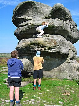
Eagle Stone, near Baslow Edge. Eagle Stone is a large weathered block of gritstone standing about 8m high. It was once a test of manhood for young men (girlhood in this case!), living in nearby villages. They had to climb the rock before they could marry. Be warned, it is not as easy as the photograph suggests, as each layer overhangs the next and the young lady in the photograph had some help getting to the point shown!
Seat on The Green in the village. This seat has survived intact since it was placed here in 1936 to celebrate the coronation of King George VI.


