Buckland in the Moor and Buckland Beacon Walk
![]()
![]() This walk climbs to Buckland Beacon near the village of Buckland-in-the-Moor in the Dartmoor National Park.
This walk climbs to Buckland Beacon near the village of Buckland-in-the-Moor in the Dartmoor National Park.
The beacon is well known for its Ten Commandments Stones and its excellent views over the Dart Valley.
The walk starts off from the Cold East Cross car park which lies just to the north of the hill. There is also a smaller roadside parking area just south of here if you would like to get a bit closer to the hill. There is limited spaces here though.
From Cold East Cross you can pick up trails heading south across the expansive Buclkand Common to the Beacon. The summit stands at a height of 382 metres (1,253 ft) and commands fine views over the area.
After admiring the views you can descend on alternative paths across the common to the car park.
If you'd like to continue your walking in the area head west to visit the Blackadon Down Nature Reserve. Here you can look out for a variety of wildlife along the River Webburn.
Please scroll down for the full list of walks near and around Buckland in the Moor. The detailed maps below also show a range of footpaths, bridleways and cycle paths in the area.
Buckland Beacon Ordnance Survey Map  - view and print off detailed OS map
Buckland Beacon Open Street Map  - view and print off detailed map
Buckland Beacon OS Map  - Mobile GPS OS Map with Location tracking
Buckland Beacon Open Street Map  - Mobile GPS Map with Location tracking
Walks near Buckland in the Moor
- River Dart Country Park - The River Dart Country Park is set in 90 acres, with lakes, parkland, woodland trails and a lovely waterside path along the River Dart
- Hembury Woods - This circular walk explores Hembury Castle Hill Fort and Hembury Woods in Buckfastleigh, Devon
- Venford Reservoir - This short circular walk takes you around the pretty Venford Reservoir on Dartmoor
- Buckfastleigh and Buckfast Abbey - This short walk from the town of Buckfastleigh takes you through the countryside to Buckfast Abbey
- Totnes River Walk - A circular walk taking you along the River Dart before heading into the countryside surrounding the town of Totnes in Devon
- Dart Valley Trail - This beautiful trail takes you along the River Dart from Totnes to Dartmouth.
The trail passes through the villages of Ashprington, Cornworthy and Dittisham before finishing at Dartmouth Harbour.
Highlights near the route include the splendid National Trust owned Greenway Estate - Ridge and Valley Walk - Follow the valley of the River Dart on this lovely walk through Devon.
The walk starts at Eggesford Barton near the train station and heads towards Chawleigh and then Leigh Bridge where you join the river - Slapton Ley - This walk takes you along Slapton Sands and the Slapton Ley National Nature Reserve in Devon
- Berry Pomeroy Castle - This walk visits Berry Pomeroy Castle near Totnes in Devon
- John Musgrave Heritage Trail - This long distance walk through South Devon follows the John Musgrave Heritage Trail from Maidencombe to Brixham.
- Holne Woods - This circular walk visits Devon's Holne Woods, near the village of Holne on the southeastern slopes of Dartmoor.
- Dartmeet - This circular walk visits the popular tourist spot of Dartmeet in the Dartmoor National Park
Photos
Buckland Beacon. The elevated position of the hill top meant that it was the location of a fire beacon to warn of danger, and the tor takes its name from this role.
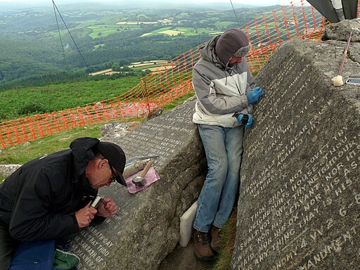
Mr. Whitley commissioned the carving of the Ten Commandments upon learning of proposed revisions to the Book of Common Prayer that would have brought the Church of England closer to Catholic doctrines. As a staunch Protestant, Whitley vehemently opposed these changes. The defeat of the proposed revisions in the House of Commons is commemorated on the rocks, along with verses from a hymn and John 13:34. Additionally, the commencement and completion dates of the carving project, from December 15th, 1927, to June 14th, 1928, are inscribed. Over time, weathering has affected the lettering, necessitating several recuttings, with the most recent one occurring in 2016 at a cost of £16,000.
In addition to the Ten Commandments, there is another carved rock on the summit of the tor, known as the Jubilee Stone.
The Jubilee Stone commemorates the Silver Jubilee of George V and bears the inscription:
1282 FT
BUCKLAND BEACON
A BEACON FIRE – ONE OF A CHAIN-
WAS LIT HERE BY THE PARISHIONERS
OF BUCKLAND-IN’THE-MOOR
IN CELEBRATION OF THEIR
MAJESTIES SILVER JUBILEE
MAY 6TH 1935
AND ALL OF THE PEOPLE SHOUTED
AND SAID GOD SAVE THE KING
Unlike the Ten Commandments rocks, the Jubilee Stone has not been maintained and is now barely visible.
It is worth noting that the inscription indicates 1282ft, which is almost 50 feet (15 m) shorter than the actual height of the beacon recorded by Ordnance Survey.
The beacon was also used for chains of fire beacons for the millennium celebrations in 2000 and for subsequent jubilees, including those of Queen Elizabeth II.


