Carrickfergus Coastal Walk
![]() Carrickfergus sits in a lovely coastal location on Belfast Lough, in County Antrim.
Carrickfergus sits in a lovely coastal location on Belfast Lough, in County Antrim.
This circular walk starts from the historic Carrickfergus Castle and then follows footpaths along the sea front. You'll then visit the pretty Marine Gardens before passing along the High Street in the town centre.
To continue your walking in the area head to the nearby Gobbins Cliff Path and the Blackhead Lighthouse for some spectacular coastal views.
Please scroll down for the full list of walks near and around Carrickfergus. The detailed maps below also show a range of footpaths, bridleways and cycle paths in the area.
Carrickfergus Open Street Map  - view and print off detailed map
Carrickfergus Open Street Map  - Mobile GPS Map with Location tracking
Walks near Carrickfergus
- Gobbins Cliff Path - The Gobbins Cliff Path is considered one of the most dramatic coastal walks in Europe
- Blackhead Lighthouse - This short circular walk visits the Blackhead Lighthouse located near Whitehead in County Antrim
- Cave Hill Country Park - Visit this wonderful country park and enjoy fabulous views over Northern Ireland on this circular walk in Belfast
- Comber Greenway - This cycling and walking trail runs along National Cycle Network route 99 and a disused railway line from Belfast to Comber
- Lagan Towpath - This cycle and walking route follows the towpath of the River Lagan from Belfast to Lisburn along National Cycle Network routes 9 and 93
- Lagan Valley Regional Park - Starting from the Shaw's Bridge car park follow the Lagan towpath along the river Lagan on this lovely walk in Belfast
- Lady Dixon Park - This 128 acre park in Belfast is a great place for an afternoon stroll
- Belvoir Park Forest - This large park in Belfast has some nice woodland trails and views of the River Lagan which runs right through the forest
- Belfast - This walk takes you on a tour of the best parks, woodland and rivers in around the city centre of Belfast.
The walk starts on the River Lagan and follows the Lagan Towpath south to Ormeau Park - Redburn Country Park - This country park in Belfast has miles of nice footpaths to try
- Black Mountain - This walk climbs to the Black Mountain above the city of Belfast.The National Trust owned area includes a popular summit walking trail taking you around Divis Mountain to the Black Mountain viewpoint.
- Belfast Castle - This historic castle in Belfast includes a lovely country park with miles of walking trails to try.
- Glenoe Waterfall - This walk visits the lovely Glenoe Waterfall in the hamlet of Glenoe in County Antrim.
Further Information and Other Local Ideas
Just to the south west you can enjoy a climb to Carnmoney Hill where there are some peaceful woodland trails and more fine views over the area.
Photos
Carrickfergus Castle, reflections at sunset. View of castle and inner harbour from the Marina and Premier Inn. The castle was built in the late 12th century at the behest of Anglo-Norman knight John de Courcy. It was the capital of the Earldom of Ulster. After the earldom's collapse, it remained the only English outpost in Ulster for the next four centuries.
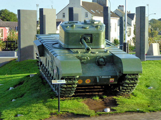
Churchill Tank and War Memorial, Carrickfergus Marine Gardens. The War Cenotaph features a cannon and full-sized, restored Churchill Mk VII tank, (a tank factory operated in the town during World War II), and the remembrance garden provides a thoughtful space to remember brave borough residents who made the ultimate sacrifice serving their country. Marine Gardens lies on the waterfront of Carrickfergus and is a beautiful parkland within sight of Carrickfergus castle. It consists of 3 distinct spaces with a winding walk as far as Fisherman’s Quay, where visitors can make their return to the castle along the delightful seafront promenade with fantastic views across Belfast Lough and beyond. (around 2km in total). The gardens include an intricate array of paved routes split by sustainable planting and are a popular spot for picnics, playing and relaxing whilst taking in views of the castle and coast. As well as the gardens it incorporates Memorial Area, Clock Tower and Children's Playground. Just a short walk away is a café and public toilets within the 'Clock Tower.' The clock has been a distinctive feature of the park since it was originally established in 1967 and incorporates a viewing platform over the wide green recreational space.


