Gobbins Cliff Walk Map
![]() The Gobbins Cliff Path is considered one of the most dramatic coastal walks in Europe. The path is located on the rugged coastline at Islandmagee, County Antrim, Northern Ireland.
The Gobbins Cliff Path is considered one of the most dramatic coastal walks in Europe. The path is located on the rugged coastline at Islandmagee, County Antrim, Northern Ireland.
It's a photogenic place with wonderful geological rock formations and lots of sea birds to look out for on the path. Keep your eyes peeled for Guillemots and Kittiwakes as you make your way along the path.
On the path there's a series of bridges and a 22-metre-long (72 ft) tunnel, including a section which runs below sea-level. There's also a viewing platform with excellent views over Belfast Lough.
Postcode
BT40 3SL - Please note: Postcode may be approximate for some rural locationsPlease click here for more information
Gobbins Cliff Path Open Street Map  - view and print off detailed map
*New* - Walks and Cycle Routes Near Me Map - Waymarked Routes and Mountain Bike Trails>>
Gobbins Cliff Path Open Street Map  - Mobile GPS Map with Location tracking
Pubs/Cafes
There is a visitor centre near the path where you'll find exhibitions, a car park, information and a cafe for refreshment.
Dog Walking
The path is not suitable for dog walking.
Further Information and Other Local Ideas
Just to the south you can visit the Blackhead Lighthouse where there's another fine coastal path to try. The path was the precursor to the Gobbin's Path and sits in a fine spot at the northern end of Belfast Lough where it opens out into the North Channel that separates Northern Ireland and Scotland.
Head towards Belfast and you can continue your walking in Redburn Country Park where there are fine views to Belfast Lough, Belfast Harbour, George Best City Airport, Belfast Castle and Cave Hill Country Park.
To the north west you can enjoy a climb to the popular Slemish Mountain. There's excellent views over the area from the summit of this viewpoint near Broughshane.
To the south west there's the Woodburn Forest near Carrickfergus. Here you'll find miles of good woodland trails and a number of attractive reservoirs.
Also nearby is the Glenoe Waterfall. The picturesque falls are located in the pretty village of Glenoe in County Antrim. It's a fine place for a walk with pleasant trails taking you through peaceful woodland to the 30ft high waterfall.
For more walking ideas in the area see the Belfast Walks page.
Cycle Routes and Walking Routes Nearby
Photos
This is a view of the cliffs from the water as seen from the Bangor Boat which runs regular trips to the cliffs in June each year, primarily to view the many birds that use the area as a nesting site. Birds seen include Puffins, Razorbills, Guillemots, Shags and Kittiwakes. Note that this picture was taken during on a very misty evening and visibility is normally much better.
Bridge at the site. The path was a popular tourist destination in the first half of the twentieth century. This had been constructed by railway magnate Dean Berkeley Wise, attracting people to take the train from Belfast to Whitehead, opening in 1902. The path remained a hit with tourists until the outbreak of the Second World War forced its closure. It reopened for a time after the war but closed again in 1962. From 2011-2015 Larne Borough Council led a project to reopen The Gobbins. A series of new bridges and galleries were constructed and installed during 2014–15. From 2011-2015 Larne Borough Council led a project to reopen The Gobbins. The path was then accessible to visitors from August 2015 by guided tour and re-opened fully on 30 June 2017.
Steps. The Gobbins Cliff Path, located on the eastern coast of County Antrim, is home to a diverse range of flora and fauna, shaped by its dramatic coastal environment. The cliffs and surrounding grasslands support hardy plant species adapted to the salty air and strong winds. Wildflowers such as thrift and sea campion thrive on the rocky ledges, while coastal grasses and ferns take root in sheltered crevices. In spring and summer, gorse bushes add splashes of yellow to the landscape. The intertidal zone beneath the cliffs is rich in marine life, including seaweeds and rockpool creatures such as crabs and anemones.
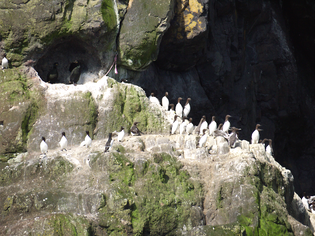
Guillemots at The Gobbins. The cliffs are a haven for seabirds, with species such as fulmars, kittiwakes, razorbills, and guillemots nesting on the rocky ledges. Puffins are also present in small numbers. Peregrine falcons, one of the fastest birds of prey, can sometimes be seen hunting along the coastline. The waters below the cliffs are home to seals, and porpoises are occasionally spotted offshore. The rugged habitat also supports butterflies and other insects, particularly in the grassy areas along the path.
Staircase view. The Gobbins Cliff Path was originally opened in 1902 as a dramatic coastal walkway featuring tunnels and bridges carved into the cliffs. Designed by Berkeley Deane Wise, a railway engineer, the path was intended to attract visitors to the area as part of the Belfast & Northern Counties Railway tourism initiatives. It became a major attraction before closing in the 1950s due to maintenance difficulties. Following extensive restoration, the path was reopened in 2016, featuring modern bridges and safety measures while maintaining its original adventurous spirit.
Nesting Kittiwakes. The route is a fully guided experience, leading visitors through tunnels and over bridges suspended above the sea. Highlights include the Tubular Bridge, the Swinging Bridge, and caves once used by smugglers. The surrounding area includes the village of Ballystrudder and Islandmagee, with its long maritime history. Nearby, Larne provides further coastal walking opportunities, while the Antrim Coast Road offers scenic views along one of Northern Ireland’s most famous driving routes.


