Cushendall Cliff Walk
![]() This walk takes you along a lovely section of the Antrim coast in the delightful Georgian village of Cushendall.
This walk takes you along a lovely section of the Antrim coast in the delightful Georgian village of Cushendall.
You can start the walk at the beach car park on the sea front and then follow a footpath north to the ruins of the ancient Layd Church.
The path rises steadily offering some wonderful views over the Bay. On a clear day you can even see Scotland's Mull of Kintyre and Ailsa Craig.
To continue your walking in the area head to the nearby Glenariff Forest Park where there's waterfalls, forest trails and riverside paths to enjoy.
Please scroll down for the full list of walks near and around Cushendall. The detailed maps below also show a range of footpaths, bridleways and cycle paths in the area.
Cushendall Open Street Map  - view and print off detailed map
*New* - Walks and Cycle Routes Near Me Map - Waymarked Routes and Mountain Bike Trails>>
Cushendall Open Street Map  - Mobile GPS Map with Location tracking
Walks near Cushendall
- Glenariff Forest Park - This 1185 hectare (2928 acre) forest has miles of walking trails including the waterfall walk and scenic trail.
The waterfall walk is particularly lovely with footpaths leading you through steep wooded gorges with a series of beautiful falls to enjoy - Ballypatrick Forest - This large forest in Northern Ireland has miles of footpaths to try
- Gobbins Cliff Path - The Gobbins Cliff Path is considered one of the most dramatic coastal walks in Europe
- Blackhead Lighthouse - This short circular walk visits the Blackhead Lighthouse located near Whitehead in County Antrim
- Slemish Mountain - Follow the Slemish Path to the 1437 ft summit of this mountain in County Antrim
- Glenarm - This walk explores the picturesque village of Glenarm in County Antrim.
- Ballycastle Fair Head Walk - This circular walk visits the wonderful cliff tops at Fair Head near Ballycastle in County Antrim.
- Rathlin Island - This walk explores the RSPB Roonivoolin Reserve on Rathlin Island off the coast of County Antrim.
- Torr Head - This walk visits Torr Head on the beautiful County Antrim coast near Ballycastle.
- Cushendun Caves - This walk visits the attractive village of Cushendun near Ballycastle in County Antrim
- Carnlough Cranny Falls - This walk takes you to Cranny Falls from the village of Carnlough in County Antrim.
Further Information and Other Local Ideas
Head north along the coast and you could try the Ballycastle Fair Head Walk. The circular loop walk takes you around a beautiful headland with some spectacular cliff top views. Near here you could also visit Torr Head. The scenic area is notable as the closest point in Northern Ireland to Scotland, with only 12 miles separating them across the Irish Sea.
In Ballycastle you can catch the ferry to the beautiful Rathlin Island. There are some splendid trails here with lots of wildlife to see in the RSPB nature reserve on the island.
Also nearby are the Cushendun Caves where you can explore a dramatic cave system and enjoy some wonderful views of the Mull of Kintyre in Scotland.
In neighbouring Carnlough you can try the Carnlough Cranny Falls Walk. This takes you along the old Mineral Railway to a picturesque waterfall and river gorge.
Photos
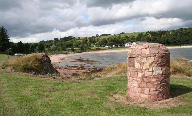
Cushendall Bay. Taken from near Limerick Point with the pillar in the foreground built to celebrate the millennium.
Layd Church. The ruins of Layd Church, a Franciscan foundation possibly partially from the 13th century, are about 1.5 km north of Cushendall. They are also accessible by road and a cliff path from Cushendall. There are old vaults in the churchyard and it was one of the main burial places of the MacDonnells. There is a stone cross memorial to Dr James MacDonnell, one of the organisers of the last Belfast Festival of Harpists in 1792 and pioneer of the use of chloroform in surgery. By the gate of the churchyard is a holestone and nearby two 'corp stones' on which coffins were rested. Layd Church saw service as a parish church from 1306 until about 1790.
High Street, Cushendall. Located on the A2 coast road between Glenariff and Cushendun, Cushendall is in the Antrim Coast and Glens an Area of Outstanding Natural Beauty. It lies in the shadow of the table topped Lurigethan Mountain and at the meeting point of three of the Glens of Antrim: Glenaan, Glenballyemon and Glencorp. This part of the Northern Irish coastline is separated from Scotland by the North Channel, with the Mull of Kintyre about 16 miles away. In the 2011 Census, Cushendall had a population of 1,280 people.
Cushendall Bridge. Much of the historic character of the 19th century settlement on the north bank of the River Dall remains, including the mostly-intact Irish Georgian buildings of the town's four original streets. In 1973, it was the second village in Northern Ireland to be designated as a Conservation Area. Since 1990, Cushendall has hosted the Heart Of The Glens festival every August. Thomas D'Arcy McGee, a father of Canadian Confederation, spent his childhood in Cushendall when his father, who worked for the Coast Guard Service, was posted there.


