Darley Abbey Park
![]()
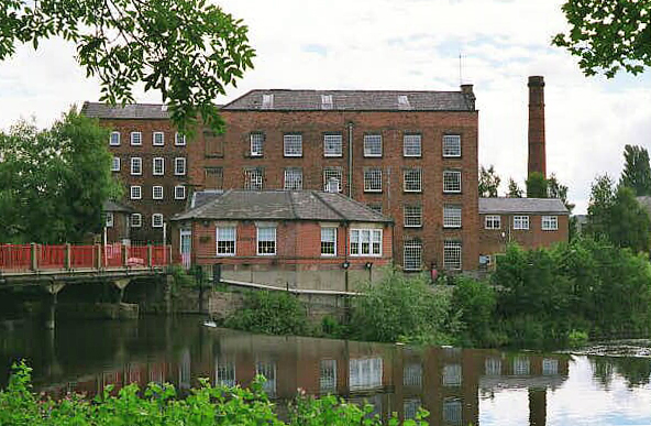
![]() Enjoy a circular walk around the parkland of this historic mill village in Derby. In the park there's a nice lake and footpaths along the River Derwent on the eastern side. There's also a cricket field and some lovely gardens to see. Notably, Darley Park is home to largest collection of Hydrangeas in Britain, and the third largest in the world. The area forms part of the wider Derwent Valley Mills World Heritage Site. Throughout the 17th and 18th centuries, a series of water powered mills – for corn, flint, leather and paper – were developed on land between Darley Street and the west bank of the River Derwent. You can explore Darley Abbey village to see the old Boars Head Mills today. There's also the 18th century cottages built for mill foremen and their families which are the oldest surviving example of "cluster" housing in England.
Enjoy a circular walk around the parkland of this historic mill village in Derby. In the park there's a nice lake and footpaths along the River Derwent on the eastern side. There's also a cricket field and some lovely gardens to see. Notably, Darley Park is home to largest collection of Hydrangeas in Britain, and the third largest in the world. The area forms part of the wider Derwent Valley Mills World Heritage Site. Throughout the 17th and 18th centuries, a series of water powered mills – for corn, flint, leather and paper – were developed on land between Darley Street and the west bank of the River Derwent. You can explore Darley Abbey village to see the old Boars Head Mills today. There's also the 18th century cottages built for mill foremen and their families which are the oldest surviving example of "cluster" housing in England.
The village's noteworthy history stretches all the way back to the 12th century as it was the site of the Augustinian monastery of Darley Abbey. There are only two remaining buildings from the monastic period. One is now the Abbey Pub (also known as the Abbey Inn), a Grade II* listed building. Constructed in the 15th century, it is thought to have been part of the Abbot's residence. The other monastic survivor makes up part of a private dwelling on Abbey Lane.
After your walk enjoy refreshments in the Darley Park Tearooms. These occupy the old school building, that was once part of the mansion, and include a terraced area with views across the park and the city beyond.
To continue your walking around Derby head south from the village and pick up the Derby Canal. Elvaston Castle Country Park is also nearby and includes a lovely lake and nice woodland trails.
Postcode
DE22 1DA - Please note: Postcode may be approximate for some rural locationsPlease click here for more information
Darley Abbey Park Ordnance Survey Map  - view and print off detailed OS map
Darley Abbey Park Open Street Map  - view and print off detailed map
Darley Abbey Park OS Map  - Mobile GPS OS Map with Location tracking
Darley Abbey Park Open Street Map  - Mobile GPS Map with Location tracking
Pubs/Cafes
The on site café is situated in the last remaining room of Darley Park's former mansion. They serve a good range of meals and snacks with great views over the park.
The Broadway pub is located on the western side of the park. The pub serves a fine Sunday roast and has a nice garden area to sit our in. You can find them on Duffield Road at postcode DE22 1JB for your sat navs.
Dog Walking
The woodland and parkland trails are popular with dog walkers so you'll probably see other owners on your visit. The on site cafe mentioned above is also dog friendly.
Further Information and Other Local Ideas
Head west from Derby along the Bonnie Prince Charlie Walk and you will soon come to Markeaton Park. The park is Derby’s most visited park and is one of the most popular attractions in the East Midlands.
To the north you'll find Allestree Park. Here there's 320 acres of parkland surrounding the 19th century Allestree Hall. Kedleston Hall also lies just to the west of here.
Just to the east you can pick up the Great Northern Greenway. This shared cycling and walking trail runs along the trackbed of the old Great Northern Railway which closed in the 1960s. It now makes for a nice easy cycle or walk and can be picked up from close to the Meteor Shopping Centre.
For more walking ideas in the area see the Derbyshire Walks page.
Cycle Routes and Walking Routes Nearby
Photos
Darley Park, towards the Cricket Club View down from the top of the park towards the Cricket Club and the River Derwent.
Darley Slade, prehistoric trackway, looking South. This trackway, also thought to have been used by the Romans, goes South into Derby, past the site of the first Roman fort in this area. Today it runs along the outskirts of the park.


