Dava Way OS Map and GPX Download
![]()
![]() A super cycling and walking route along a dismantled railway line from Forres in Moray to Grantown On Spey, Highland.
A super cycling and walking route along a dismantled railway line from Forres in Moray to Grantown On Spey, Highland.
The route passes through a pleasant mixture of farmland, woodland and moorland while also crossing the River Divie at Glenernie. It provides a link between the Speyside Way in the south and the Moray Firth Trail to the north.
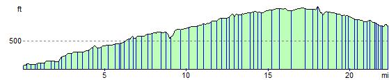
Views from the trail include Nairn, Inverness, Moray, Ross & Cromarty, the Cromdale Hills and the Cairngorm Mountains.
For cyclists a mountain bike or hybrid is advised.
Please click here for more information
Dava Way Ordnance Survey Map  - view and print off detailed OS map
Dava Way Open Street Map  - view and print off detailed map
*New* - Walks and Cycle Routes Near Me Map - Waymarked Routes and Mountain Bike Trails>>
Dava Way OS Map  - Mobile GPS OS Map with Location tracking
Dava Way Open Street Map  - Mobile GPS Map with Location tracking
Further Information and Other Local Ideas
Forres is also the start point for the Moray Coast Trail. You could pick up the trail here and follow it north to the lovely Findhorn Bay where there are excellent bird watching opportunites.
Just south of Forres you'll pass the Darnaway Forest where you could take a small detour to visit Logie Steading and the Findhorn River. The estate includes some fine riverside walks, a garden centre, a cafe and some splendid waterfalls at the photogenic Randolph's Leap.
For more walking ideas in the area see the Cairngorms Walks page.
Cycle Routes and Walking Routes Nearby
Photos

A railway shed of yesterday south of Auchlochan. The path traverses a diverse landscape of open moorland, agricultural fields and ancient woodlands, offering walkers and cyclists gentle gradients and expansive vistas. As you travel along the route, you are treated to panoramic views over the Moray Firth and surrounding hills, with the climb across Dava Moor leading to a summit at about 320 metres above sea level that reveals the quiet majesty of the Scottish countryside and the subtle traces of its industrial heritage in the form of restored railway structures and viaducts.

Bridge over Allt na Ceardaich. On the former Highland Railway now the Dava Way. Along the Dava Way, the natural environment is richly rewarding. The trail is bordered by woodlands where native species such as Scots pine, birch and oak create a sheltering canopy that supports a variety of birdlife including red grouse, skylarks and, on occasion, soaring buzzards. In the open moorland, colourful heather and wildflowers bloom in the summer, providing a vibrant contrast to the muted tones of the rugged terrain, while these areas also support small mammals like hares and voles. The adjacent farmlands further enhance the biodiversity, attracting pollinators and insects that contribute to the overall ecological tapestry of the area, making the Dava Way an ideal route for those seeking to experience Scotland’s natural and cultural heritage in a single, immersive walk.

Sign on the trail. Highest point on the line of the old Highland Railway on Dava Moor. Although the sign looks new it gives the height in feet.

Track of the former Highland Railway

Old bridge at Dunphail

The former Braemoray Public house

Gatehouse of Castle Grant. Located on the A939 between Grantown on Spey and Glaschoil is the gatehouse to Castle Grant and railway bridge of the old Highland Line. The old track bed is now part of the 23 mile Dava Way footpath and cycle way between Grantown on Spey in the South and Forres in the North.

The long-distance path mostly follows the route of the former Grantown to Forres railway line. This is looking towards Forres from an overbridge at Peathillock near Logie. The path was very wet after heavy rain.
Elevation Profile