Craster to Dunstanburgh Castle Walk
![]()
![]() This walk takes you along a beautiful stretch of the Northumberland Coast Path from Craster to Dunstanburgh Castle and then on to Embleton Bay and the Newton Pool Nature Reserve.
This walk takes you along a beautiful stretch of the Northumberland Coast Path from Craster to Dunstanburgh Castle and then on to Embleton Bay and the Newton Pool Nature Reserve.
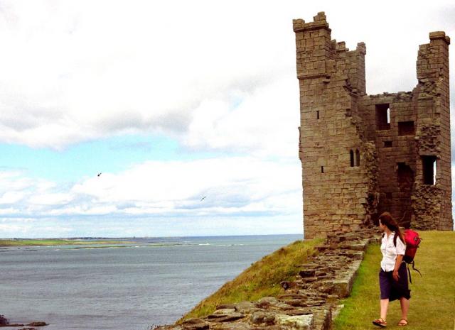
Dunstanburgh Castle was built in the 14th century, being one of the largest and grandest fortifications in Northern England at the time. The dramatic ruins are now a popular tourist attraction, standing on a remote headland with fine views of Embleton Bay and Craster.
This walk starts at the small fishing village of Craster and follows the coastal path past the castle to Embleton Bay where you will find a lovely beach and sand dunes. You continue to the Newton Pool Nature Reserve where you can use the bird hides to look out for Herons and Barn Owls.
The castle is located about 5 miles north east of Alnwick where you can continue your walking in the lovely Hulne Park or around Alnwick Castle and gardens. The extensive park has several waymarked trails with woodland, riverside paths and wonderful views from the high points.
The St Oswald's Way walking route runs past the castle so you could extend your walk along this footpath.
Heading north with take you to Beadnell where you will find the lovely Beadnell Bay with its 2 mile long sandy beach.
You can also try our Craster Circular Walk and visit the Arnold NWT Nature Reserve and the interesting cliff formations at Cullernose Point.
Please click here for more information
Craster to Dunstanburgh Castle Ordnance Survey Map  - view and print off detailed OS map
Craster to Dunstanburgh Castle Open Street Map  - view and print off detailed map
*New* - Walks and Cycle Routes Near Me Map - Waymarked Routes and Mountain Bike Trails>>
Craster to Dunstanburgh Castle OS Map  - Mobile GPS OS Map with Location tracking
Craster to Dunstanburgh Castle Open Street Map  - Mobile GPS Map with Location tracking
Pubs/Cafes
Back in Craster the Jolly Fisherman is a good choice for some post walk refreshment. The historic pub includes a fine interior with roaring fires, stone flagged floors and low beamed ceilings. They serve delicious sea food which you can enjoy with a lovely sea view over Craster's delightful harbour. You can find them at Haven Hill at postcode NE66 3TR for your sat navs.
Dog Walking
The coastal paths make for a fine dog walk. You are asked to please keep them on leads around the castle. The Jolly Fisherman mentioned above is also dog friendly.
Further Information and Other Local Ideas
The area is great for wildlife so keep your eyes peeled for various sea birds and dolphins as you make your way along the path.
To visit more significant historical sites in the area try the Alnwick to Bamburgh Walk. This starts from the 11th century Alnwick Castle and passes Dunstanburgh before heading to Bamburgh Castle with its 12th century keep.
For more walking ideas in the area see the Northumberland Walks page.
Cycle Routes and Walking Routes Nearby
Photos
Dunstanburgh Castle and Embleton Bay. Built in the 14th century by the powerful Percy family, the castle stands dramatically on a headland overlooking the North Sea. The castle was intended to be an imposing fortress, and its strategic position made it a significant military site. It was partly destroyed during the English Civil War, but the ruins still evoke the grandeur of its former self. Today, it’s a popular spot for visitors interested in both its historical significance and its stunning location. The surrounding landscape, with its rugged cliffs and expansive views, enhances the experience of visiting the castle, making it a highlight of the walk.
Northumberland Coast Path to Dunstanburgh Castle. Along the route, you will find a mix of saltmarsh, heathland, and rocky shoreline, which provide a habitat for a wide range of plants. Coastal grasses such as fescue and ryegrass thrive here, alongside wildflowers like thrift, sea campion, and primroses. The area also supports a variety of hardy shrubs, including gorse and broom, adding to the rich biodiversity of the walk.
Cattle, St Oswald's Way. View of the path looking towards the castle. Birdlife along the route is abundant, especially in the warmer months. The coastline is frequented by seabirds such as puffins, guillemots, and razorbills, with plenty of opportunities to spot them nesting on the cliffs. The rocky areas also attract other species, including cormorants, fulmars, and kittiwakes. You may also see smaller birds like meadow pipits, skylarks, and reed buntings, which are common in the grassy areas. The walk offers a good chance to see birds of prey as well, with kestrels and peregrine falcons regularly sighted. Additionally, the area is home to various butterflies, dragonflies, and insects, particularly in the summer.


