Ellastone Walks
![]()
![]() This Staffordshire based village has some nice riverside trails along the River Dove and through the nearby Churnet Valley. There's also some interesting history with a 16th century church and the site of a 12th century ruined abbey to visit.
This Staffordshire based village has some nice riverside trails along the River Dove and through the nearby Churnet Valley. There's also some interesting history with a 16th century church and the site of a 12th century ruined abbey to visit.
This walk from the village uses part of the Limestone Way to visit some of the highlights of the area including Calwich Abbey Abbey, the River Dove, Norbury and the ancient Rocester Roman Fort.
The walk starts at the public car park in the village and heads south to link up with the Limestone Way. You can follow this waymarked footpath south along the River Dove to Riverside Doveley, crossing into Derbyshire at Norbury. The Dove is notable as the historic boundary between the two counties of Derbyshire and Staffordshire. The route then continues past Dalesgap before coming to Rocester. In this historic village a Roman fort was founded in about 69 AD, as an intermediate point between Derby and Newcastle Under Lyme on a route later known as Long Lane. The remains of the earthworks can still be seen today.
The route then retraces its steps before turning east to visit Norbury with its weir and old church.
You then cross the Dove before following footpaths around Calwich Park and Abbey. The route then returns to the village via Upper Ellastone.
Postcode
DE6 2GZ - Please note: Postcode may be approximate for some rural locationsEllastone Ordnance Survey Map  - view and print off detailed OS map
Ellastone Open Street Map  - view and print off detailed map
Ellastone OS Map  - Mobile GPS OS Map with Location tracking
Ellastone Open Street Map  - Mobile GPS Map with Location tracking
Walks near Ellastone
- Denstone - This route uses a section of the Churnet Valley Railway Path and the Staffordshire Way to create a circular walk around the Staffordshire based village
- Uttoxeter - This Staffordshire based market town has some nice river and country trails to try.
- Churnet Valley - This walk takes you through Staffordshire's beautiful Churnet Valley from Froghall to Cheddleton
- Ashbourne - The Derbyshire Dales town of Ashbourne is a fantastic base for walkers looking to explore the southern end of the Peak District
- Weaver Hills - This circular walk explores the Weaver Hills area of the White Peak
- Croxden Abbey - This walk visits the ruins of a 12th century abbey near Hollington in Staffordshire.
- Dimmingsdale - Explore the Dimmingsdale Valley and Furnace Forest on this lovely wooded walk
- Walk Around Alton - This Staffordshire village is most well known for the Alton Towers Theme Park but it also has some lovely walks to try
- Doveridge - This quiet Derbyshire based village sits close to the border with Staffordshire and the River Dove
Pubs/Cafes
After your exercise enjoy refreshments at the splendid Duncombe Arms in the village. The 1850s inn has a charming interior with blazing fires. Outside there's a lovely large garden area to relax in on warmer days. You can find them on the Main Road at postcode DE6 2GZ.
Dog Walking
The country, river and parkland trails make for a fine dog walk. The Duncombe Arms mentioned above is also very dog friendly with water and treats available.
Further Information and Other Local Ideas
Just to the south west you can pick up the Denstone Railway Walk from the neighbouring village. The route uses a section of the Churnet Valley Railway Path and the Staffordshire Way to create a circular walk. On the way you'll pass Alton Towers, the peaceful woods at Dimmingsdale and Denstone Hall.
For more walking ideas in the area see the Staffordshire Walks and the Peak District Walks pages.
Photos
The second country house to be built on the site of Calwich Abbey (formerly Calwich Priory, founded in 1130) was frequented by the composer Handel, the philosopher Rousseau, Erasmus Darwin and the poet Anna Seward.
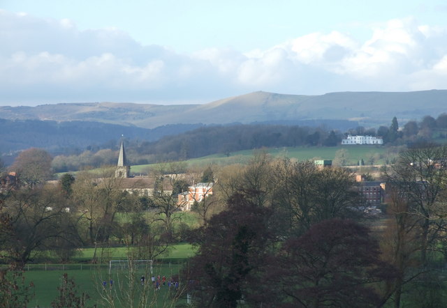
View over Rocester, Staffordshire. On the left are the tower and spire of St Michael's parish church. The red brick building to the right is Tutbury Mill, a water-powered cotton mill built for Richard Arkwright in 1781-2 beside the River Dove. It has now been converted into the JCB Academy. The white mansion part-way up the hill on the right is Barrow Hill, now a retirement home. On the horizon are the Weaver Hills, the highest of which has a summit 371 meters above sea level. The football game in the foreground is being played at Abbotsholme School.


