Elsdon Walks
![]()
![]() This attractive village in the Northumberland National Park is a lovely place for a stroll. Features include an ancient church, a large village green, the remains of the old motte and bailey castle, a noteworthy Pele tower and views of the lovely Redesdale countryside.
This attractive village in the Northumberland National Park is a lovely place for a stroll. Features include an ancient church, a large village green, the remains of the old motte and bailey castle, a noteworthy Pele tower and views of the lovely Redesdale countryside.
This circular walk from the village starts from the car park and takes you around the medieval castle before heading through the countryside to Hudspeth. You can continue your walk on the circular Elsdon Burn Walk.
The village is located close to the expansive Harwood Forest and the Simonside Hills. The forest can be found a few miles east of the village and contains miles of excellent walking and cycling trails.
Elsdon Ordnance Survey Map  - view and print off detailed OS map
Elsdon Open Street Map  - view and print off detailed map
*New* - Walks and Cycle Routes Near Me Map - Waymarked Routes and Mountain Bike Trails>>
Elsdon OS Map  - Mobile GPS OS Map with Location tracking
Elsdon Open Street Map  - Mobile GPS Map with Location tracking
Walks near Elsdon
- Harwood Forest - Enjoy a largely traffic free cycle ride through Harwood Forest and the Simonside Hills in the Northumberland National Park
- Fontburn Reservoir - This circular walk takes you around the lovely Fontburn Reservoir in Northumberland
- Simonside Hills - The Simonside Hills are a fabulous place for walkers with miles of footpaths taking you through woodland and moorland to wonderful viewpoints
- Otterburn - This circular walk follows the Otterburn Village Trail around this Northumberland village
- Shaftoe Crags - Climb to Shaftoe Crags and enjoy far ranging views over the Northumberland countryside on this circular walk near Morpeth
- Rothbury - Rothbury is located in the Northumberland National Park on the edge of the Simonside Hills
- Sweethope Loughs - This walk visits the Sweethope Loughs in Northumberland, near Bellingham.
- Colt Crag Reservoir - This walk visits the lovely Colt Crag Reservoir near Hexham and Corbridge in Northumberland.
- Alwinton River Alwin Circular Walk - This Northumberland based village has some lovely heather moorland, riverside trails, interesting geology, hill climbs and a historic old castle to explore
- Usway Burn - River Coquet - Upper Coquetdale Walk - Enjoy some lovely waterside walking along the Usway Burn and the River Coquet on this route in the Upper Coquetdale area of the Northumberland National Park
- Kidland Forest - Explore Kidland Forest and Upper Coquetdale on this circular cycle ride in the Northumberland National Park
- Harbottle Crags and Woods Walk - This circular walk from the Northumberland village of Harbottle climbs to Cold Law, Dove Crag and Harbottle Crags
- Otterburn Ranges - This walk explores the Otterburn Ranges, an expansive Ministry of Defence owned area of the Northumberland National Park.
- Drake Stone and Harbottle Castle Circular Walk - This circular walk visits two of the historic highlights of the Northumberland National Park.
- Tosson Hill and Simonside Circular Walk - This walk climbs to the highest hill in the Simonside Hills near Rothbury in Northumberland.
Pubs/Cafes
Back in the village there's the Bird in Bush Public House for some post exercise relaxation and refreshment. They have a car park, garden area and restaurant. You can find them next to the village green at postcode NE19 1AA for your sat navs.
The cycle friendly Impromptu Cafe is just up the road and does a fine selection of cakes.
Dog Walking
The country trails make for a pleasant dog walk and the Bird in Bush mentioned above is also dog friendly.
Further Information and Other Local Ideas
For more walking ideas in the area see the Northumberland National Park Walks page.
Photos
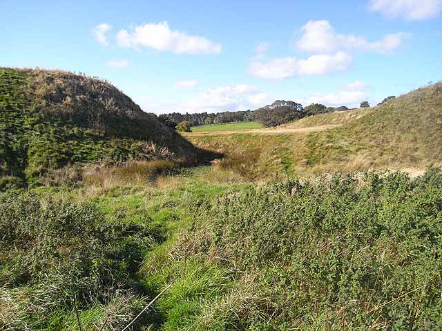
Motte and Bailey Castle at Elsdon. A medieval Motte and Bailey castle, probably the finest surviving example in Northumberland. This image shows the Motte (to the left) and the massive earthworks surrounding the Bailey which lies to the north of the Motte. The castle was probably built on the site of an Anglian Moot in the 11th century by Robert de Umfraville (one of the members of a noble family involved in the Norman conquest, possibly a cousin of William the Conqueror). Subsequently the family seat was moved to the more accessible Harbottle Castle.


