Around Falmouth Walk - Quay, Castle and Coast
![]()
![]() A coastal walk around the Cornish town of Falmouth visiting Pendennis Point, Pendennis Castle and the pretty Swanpool lake nature reserve.
A coastal walk around the Cornish town of Falmouth visiting Pendennis Point, Pendennis Castle and the pretty Swanpool lake nature reserve.
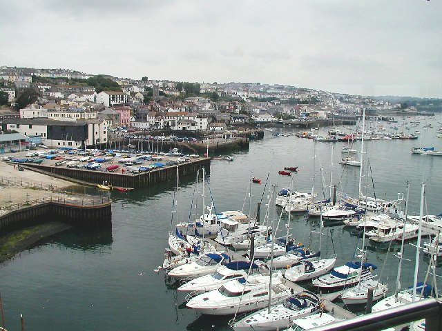
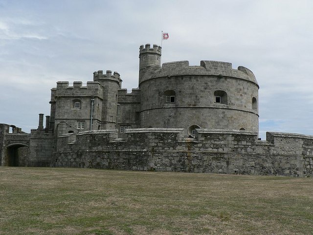
Starting at the pier the walk follows the South West Coast Path past the quays and docks to Pendennis Castle. The artillery fort was constructed by Henry VIII between 1540 and 1542. It is run by English Heritage so you can explore the battlements, war rooms, barracks and cells with exhibitions detailing the history of the castle. It's in a fantastic position, commanding fine views across Falmouth Bay to the Roseland Peninsula.
After leaving the castle the footpath rounds Pendennis Point and heads west to Swanpool, passing two nice beaches on the way. The small saline lagoon is great for wildlife watching with Little grebe, Tufted Duck and Moorhen to look out for. It's a really lovely spot with the lake separated from the sea by the pretty Swanpool beach. The site also includes and outdoor cafe, crazy golf course, water-sports and kayak hire.
To extend your walking in the area you could explore the beautiful Roseland Peninsula. You can catch a ferry from Falmouth to St Mawes where you can try the St Mawes to St Just Walk. This visits the fascinating St Mawes Castle and the St Just in Roseland 13th-century church with beautiful riverside gardens.
Also near to Falmouth is the delightful Glendurgan Garden, the beautiful estuary of the Helford River and Kennall Vale Nature Reserve.
Falmouth Ordnance Survey Map  - view and print off detailed OS map
Falmouth Open Street Map  - view and print off detailed map
Falmouth OS Map  - Mobile GPS OS Map with Location tracking
Falmouth Open Street Map  - Mobile GPS Map with Location tracking
Explore the Area with Google Street View 
Walks near Falmouth
- St Mawes to St Just - This walk takes you along a lovely stretch of coast on the Roseland Peninsula in Cornwall
- Glendurgan Garden - These lovely National Trust owned gardens are located near Falmouth in Cornwall
- South West Coast Path - This incredible 600 mile walk follows the coast from Minehead in Somerset, through Devon and Cornwall and onto the finish point at Poole in Dorset
- Roseland Peninsula - Explore the beautiful Roseland Peninsula on this 10 mile walk on the Cornish coast
- Kennall Vale - This nature reserve near Falmouth has a series of walking trails to follow
- Trebah Garden - Follow over 4 miles of walking paths in these stunning Cornish gardens
- Helford River Walk - This circular walk follows a section of the South West Coast Path along the lovely Helford River in Cornwall
- Portloe - This pretty Cornish village includes a picturesque harbour and some fine walks into the surrounding Cornwall Area of Outstanding Natural Beauty.
- Argal Reservoir - This walk visits the lovely Argal Reservoir near Penryn and Falmouth in Cornwall
- Penryn - This Cornish based town has some lovely river and coastal walks to try
- St Mawes - This walk from St Mawes explores the Roseland Peninsula visiting the lovely Hidden Hut Cafe in Portscatho.
- Falmouth to Swanpool and Maenporth Walk - This walk visits some of the local highlights near the Cornish town of Falmouth.
Further Information and Other Local Ideas
Just west of the town there's a good circular trail to follow around Argal Reservoir. There's also the ancient Mabe church and a boardwalk on the adjacent College Reservoir to see here.
Head north and you can pick up the Penryn Walk which will take you along the Penryn River to Flushing where you can catch a ferry to Falmouth. The town itself is also worth exploring with a historic conservation area where you'll find a number of Tudor, Jacobean and Georgian properties. The pretty harbour and wharf also includes a fine riverside cafe.
Just to the north there's the worthy village of Mylor Bridge where you can enjoy some lovely waterside walks along the Mylor Creek and Restronguet Creek, on the beautiful Fal Estuary.
For more walking ideas in the area see the Cornwall Walks page.
Photos
Pendennis Point from the Henrician Castle. Looking down from the ramparts of the Henrician Castle. The building in mid-foreground is part of the Half-Moon Battery. Beyond it the roof of the Coastguard Centre.
Pendennis Castle from within the Governor's Lodging. Looking out at the east side of the castle, and across Carrick Roads towards St Mawes. The Governor's Lodging consists of rooms in the oldest part of Pendennis, The Henrician Castle, which was constructed during the reign of Henry VIII. St Mawes Castle is just visible through the right-hand middle pane, and was built at the same time.


