Gilwern Canal Walk
![]()
![]() This walk from the little village of Gilwern takes you along a pleasant section of the Monmouthshire and Brecon Canal to neighbouring Llangattock.
This walk from the little village of Gilwern takes you along a pleasant section of the Monmouthshire and Brecon Canal to neighbouring Llangattock.
Here you can enjoy a climb to the Llangattock Escarpment for some fine views over the area. There's also the Craig y Cilau National Nature Reserve with its wonderful limestone scenery and interesting rare plantlife.
The route then follows some pleasant country lanes back to Gilwern.
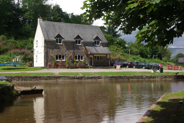
The walk starts in the car park near the pretty Gilwern Wharf to the north of the village. The attractive wharf is a popular place for a stroll with some lovely scenery and a fine canalside pub to relax in after your exercise. Follow the towpath north west toward Llangattock where you leave the canal to climb to the limestone cliffs of the Llangattock Escarpment. The route then heads south east through some lovely countryside, on a series of quiet country lanes. You'll pass Llanelly before returning to Gilwern.
Postcode
NP7 0EL - Please note: Postcode may be approximate for some rural locationsGilwern Ordnance Survey Map  - view and print off detailed OS map
Gilwern Open Street Map  - view and print off detailed map
Gilwern OS Map  - Mobile GPS OS Map with Location tracking
Gilwern Open Street Map  - Mobile GPS Map with Location tracking
Walks near Gilwern
- Monmouthshire and Brecon Canal - Follow the Monmouthshire and Brecon Canal from Brecon to Newport on this super waterside walking and cycling route
- Llangattock - This pretty village lies in a lovely spot within the Black Mountains, the Brecon Beacons and the Usk Valley
- Abergavenny Sugarloaf Walk - This epic circular walk takes you to the summit of Sugarloaf Mountain from the town of Abergavenny
- Abergavenny Castle and River Usk Circular Walk - This lovely circular walk takes you around the pretty meadows surrounding Abergavenny Castle
- Clydach Gorge - This beautiful gorge in the Brecon Beacons includes a steep-sided valley down which the River Clydach flows to the River Usk.
- Crickhowell River Walk - A short stroll along the River Usk in the town of Crickhowell (Crug Hywel) in the Brecon Beacons.
The walk starts next to Crickhowell Castle also known as 'Alisby's Castle' - Crickhowell Canal Walk - A waterside walk along the Monmouthshire and Brecon Canal from Crickhowell to Llangynidr.
The route runs for about 5.5 miles along the towpath with a shady section at the start before nice views over the surrounding hills and countryside as you approach Llangynidr.
The walk starts in the centre of Crickhowell and crosses the River Usk before following country lanes to the canal at the village of Llangattock - Blorenge - This challenging walk takes you around this prominent hill in the southeastern corner of the Brecon Beacons National Park
- Pontypool - This Torfaen county based town has a fine local park and waterside trails along the local river and canal.
- Raglan - This Monmouthshire based village is located close to Monmouth and Abergavenny
- Blaenavon - This interesting town in Torfaen county is part of the Blaenavon Industrial Landscape, a UNESCO World Heritage Site
- Goytre Wharf - This circular walk from the Goytre Wharf takes you along a section of the Monmouthshire and Brecon Canal before exploring the countryside to the west of the wharf.
- Keepers Pond - This walk visits the delightful Keeper's Pond in Blaenavon.
- Llanfoist Canal Walk - This Monmouthshire based village is close to a major canal and the wonderful scenery of the Brecon Beacons National Park.
- Craig y Cilau - This walk visits the Craig y Cilau National Nature Reserve near the village of Llangattock in Powys.
Pubs/Cafes
The Towpath Inn is the ideal place for some post walk refreshment. It's located in a fine spot, next to the canal so you can sit outside next to the water and watch the world go by. On Friday's they have Street Food pop ups where traders bring their exciting and varied menus with dishes from all over the world. You can also hire ebikes here to explore the area in comfort. The inn can be found at 49 Main Rd, NP7 0AU.
Dog Walking
The canal and country paths make for a fine dog walk. The Towpath Inn mentioned above is also dog friendly.
Further Information and Other Local Ideas
Just to the west of the village there's the wonderful Clydach Gorge to explore. The scenic steep-sided valley is where the River Clydach flows to the River Usk.
Just to the east is Abergavenny where you can visit Abergavenny Castle Meadows and Linda Vista Gardens or try the climb to Sugarloaf Mountain.
For more walking ideas in the area see the Black Mountains Walks and the Brecon Beacons Walks pages.
Photos
Marina at Pen-pedair-heol. There are relatively few privately owned boats on the Monmouthshire and Brecon Canal, probably because it is self-contained and does not connect with the rest of the canal network. Consequently, the few marinas are smaller than the vast affairs to be found on busier canals. This one is just east of bridge 110.
Llangattock Escarpment. Travelling east above the edge of a small quarry beside the Beaufort road and rounding a bend to the southeast gives this spectacular view along the larger run of quarries.


