Great Gaddesden Walks
![]()
![]() Great Gaddesden has some pleasant riverside footpaths, a Grade I listed church and some fine country trails into the surrounding Ashridge Estate.
Great Gaddesden has some pleasant riverside footpaths, a Grade I listed church and some fine country trails into the surrounding Ashridge Estate.
This circular walk from the village takes you along the River Gade before passing the ground old house at Gaddesden Place.
To continue your walking around the village head north to visit the sister village of Little Gaddesden. Here you can explore the beautiful Ashridge House Estate on the Ashridge Boundary Trail.
Great Gaddesden Ordnance Survey Map  - view and print off detailed OS map
Great Gaddesden Open Street Map  - view and print off detailed map
Great Gaddesden OS Map  - Mobile GPS OS Map with Location tracking
Great Gaddesden Open Street Map  - Mobile GPS Map with Location tracking
Cycle Routes and Walking Routes Nearby
Photos
River Gade at Great Gaddesden. Viewed looking southwards and downstream, the channel of the River Gade was dry upstream of this point.
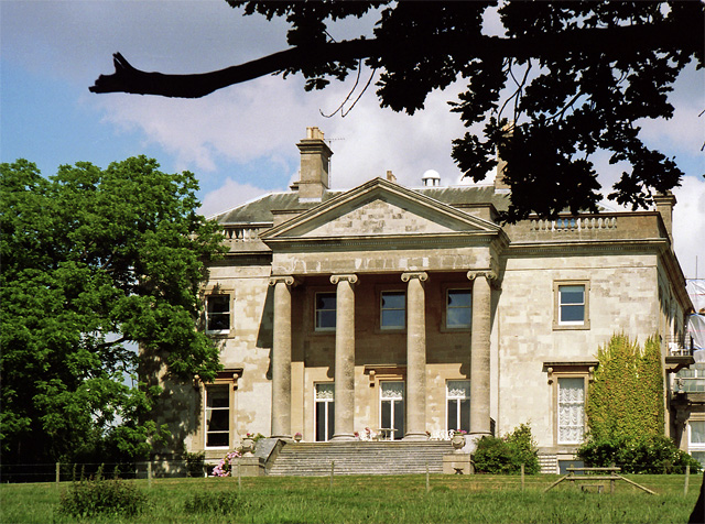
Gaddesden Place, Great Gaddesden. Not a large house but with a grand Ionic portico. It was designed by James Wyatt, 1768-73, begun when he was only 22 and yet to acquire the flair which distinguished the rest of his career, making it his first known commission. Originally it was built in Totternhoe stone, but partly renewed in Bath stone during C20th restoration. Grade II* listed. The date of the photo is uncertain.
Church of St John the Baptist, Great Gaddesden, Hertfordshire. The six tomb chests here (one on the south side and five on the east side of the chancel, enclosed in the railings) are to the Greene family and are Grade II Listed
River Gade at Great Gaddesden: Broadwater Lake. In the absence of any names on any maps, or any obvious history on the internet, I have called this Broadwater Lake after the nearby nursery. Given that water levels in the River Gade in this upstream reach very close to its source can fluctuate quite markedly over short spells of time, this was probably a man-made impoundment, created by the road bridge, to try to maintain some water in the river. The lake is about 180 metres long and about 40 metres wide at its maximum width.


