Ashridge Boundary Trail
![]()
![]() This walk takes you on a tour of the National Trust owned Ashridge Estate in the Chiltern Hills. The estate consists of 5,000 acres of woodlands, commons and chalk downland which supports a rich variety of wildlife.
This walk takes you on a tour of the National Trust owned Ashridge Estate in the Chiltern Hills. The estate consists of 5,000 acres of woodlands, commons and chalk downland which supports a rich variety of wildlife.
The walk starts at the Ashridge Estate Visitor Centre next to the Bridgewater Monument, erected in 1832 to the Duke of Bridgewater. You can climb the monument for fabulous panoramic views of the estate before starting the circular tour of the beautiful grounds.
Highlights on the walk include the Golden Valley to the north-east of Little Gaddesden and Ashridge House which was created by famous landscape gardener Capability Brown in the 18th century. You will also visit Ivinghoe Beacon, with its splendid views of the Vale of Aylesbury, Berkhamsted Common and Dunstable Downs. Another highlight of the walk is the popular Dockey Wood.
The little wood is located towards the north eastern section of the estate and is covered in pretty bluebells in the spring months.
Our Chilterns Pub Walk starts from the nearby Greyhound Inn in Aldbury. It visits Aldbury common before climbing up to Ivinghoe Beacon and returning to the popular pub for refreshments.
Please click here for more information
Ashridge Boundary Trail Ordnance Survey Map  - view and print off detailed OS map
Ashridge Boundary Trail Open Street Map  - view and print off detailed map
Ashridge Boundary Trail OS Map  - Mobile GPS OS Map with Location tracking
Ashridge Boundary Trail Open Street Map  - Mobile GPS Map with Location tracking
Pubs/Cafes
The Greyhound Inn is a charming pub with extensive dining areas & plenty of nooks and crannies, as well as a lovely outside terrace for those warm spring and summer days. They have an excellent menu and can be found in Aldbury village on Stocks Road at a postcode of HP23 5RT. The pub is also dog friendly if you have your canine friend with you.
Just off the route near the Beacon you could take a small detour to visit the village of Ivinghoe. Here you'll find the The Rose and Crown which has a good menu and a nice courtyard garden area. You can find them on Vicarage Lane at postcode LU7 9EQ. They are also dog friendly.
The King’s Head is also worth consideration being set in a 16th century, grade two listed building. They are renowned for their delicous duck dish and can be found on Station Road at postcode LU7 9EB.
Dog Walking
The miles of woodland trails on the estate make it a premier place for dog walkers so you'll probably see other owners on your visit. It's mostly off lead but you are asked to keep them on leads in areas where there are grazing animals.
Further Information and Other Local Ideas
Close to Ivinghoe Beacon you'll find one of the historical highlights of the area at Pitstone Windmill. The National Trust owned mill dates back to the 17th century and as is Grade II listed. For a small fee you can explore both the inner and outer workings of the mill and learn about the grinding of the flour in the milling process. The climb to the Beacon also starts from the windmill car park.
For more walking ideas in the area see the Chilterns Walks and Buckinghamshire Walks pages.
Cycle Routes and Walking Routes Nearby
Photos
The National Trust Visitors Centre, Ashridge. The centre includes a bookshop, café, exhibition room and caters for school parties and holds special events
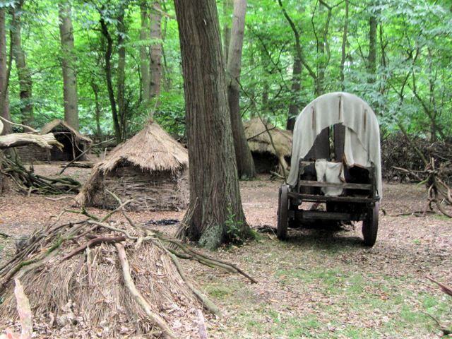
A Medieval Village in Thunderdell Wood, Ashridge. You can never be sure what you will find when wandering through the woods of the Ashridge Estate - and on this occasion I found what was clearly meant to be a Medieval Village. A quick glance at the flimsy structures showed that it was yet another film set and a passer-by said they had been filming "Robin Hood." The set would have needed a large area for all the equipment, parking, etc, associated with the set.
Autumn Splendour on Monument Drive, Ashridge This long drive, and the avenue beyond, runs between the Bridgewater Monument (behind the photographer) and Ashridge House, which can just be seen between the trees in the distance.
Monument Cottage. This is the old Caretaker's Cottage, and the 1901 census shows the caretaker to be a 67 year old widow, Mrs Hannah Willmore. A postcard published a few years later show the cottage, much as it is today, and the 73 year old Mrs Willmore. It states that she had been caretaker for 27 years.
Elevation Profile


