Hadleigh Country Park
![]()
![]() This lovely park is located on the Thames Estuary near Southend on Sea. The park is nearly 400 acres in size and includes a mix of woodland, pasture, hay meadow and marsh. There are a number of great trails suitable for cyclists and walkers. There is also the 13th century Hadleigh castle ruins where there are fabulous views of the surrounding Essex countryside and the River Thames.
This lovely park is located on the Thames Estuary near Southend on Sea. The park is nearly 400 acres in size and includes a mix of woodland, pasture, hay meadow and marsh. There are a number of great trails suitable for cyclists and walkers. There is also the 13th century Hadleigh castle ruins where there are fabulous views of the surrounding Essex countryside and the River Thames.
The Saffron Trail passes through the park so you can pick this up to extend your walk. The long distance trail takes you from the coast at Southend-on-Sea to Saffron Walden through some lovely Essex countryside.
Just to the east of the park you will find the Two Tree Island nature reserve. The expansive site has some nice footpaths taking you around grassland, scrub, reedbed and lagoons.
If you head south from the park you can cross Benfleet Creek and pick up the coastal path around Canvey Island.
Postcode
SS7 2PP - Please note: Postcode may be approximate for some rural locationsPlease click here for more information
Hadleigh Country Park Ordnance Survey Map  - view and print off detailed OS map
Hadleigh Country Park Open Street Map  - view and print off detailed map
Hadleigh Country Park OS Map  - Mobile GPS OS Map with Location tracking
Hadleigh Country Park Open Street Map  - Mobile GPS Map with Location tracking
Pubs/Cafes
The lovely Hadleigh Tea Rooms are the ideal place to relax and enjoy refreshments after your exercise. There's a delightful terrace with idyllic views overlooking Hadleigh Castle, Hadleigh Country Park and the Thames Estuary. The tea rooms are staffed by Trainees from the adjacent Salvation Army Hadleigh Training Centre. You can find the tea rooms on Castle Lane at a postcode of SS7 2AP.
Dog Walking
The park is a popular place for dog walkers and you'll probably see plenty of other owners on a fine day. The Hadleigh tea rooms mentioned above also allow dogs on the terrace.
Further Information and Other Local Ideas
Just to the north east you will find some fine woodland trails around Belfairs Woods and Hadleigh Great Wood. The area is also a nature reserve with a discovery centre and lots of wildlife to see.
For more walking ideas in the area see the Essex Walks page.
Cycle Routes and Walking Routes Nearby
Photos
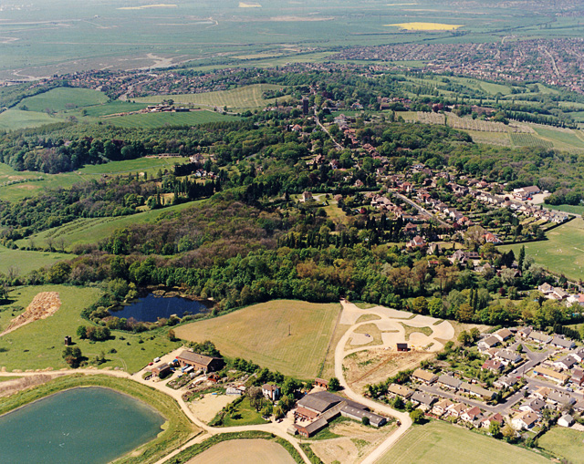
Aerial view of Hadleigh Country Park, parking area. The car parking are for the Country Park (accessed via Chapel Lane) lies below left of centre. Chapel Lane itself lies out of view below the area of the photo. The road running from near the upper centre, down to the below centre right is Benfleet Road. The darker of the two pools visible here is long established, the paler pool (bottom left) is more recent in origin.
Canvey Island seen from Hadleigh Country Park. The sun shining over Canvey Leigh Beck and reflecting off the waters of Benfleet Creek on a bright winter's day.
Aerial view of the western end of the park. This shows the two types of habitat in Hadleigh Country Park. The higher ground and slopes (Hadleigh Downs) occupy a band from just above centre-left to just below centre-right. Below and to the right of this is the Hadleigh Marsh. The pale line at the edge of this is to top of the (recently completed) new sea wall. To the left of this is Benfleet Creek, with Canvey Island on the other side.
Opening of Hadleigh Castle Country Park in 1987. The park was a long time in gestating. Much of the drive for its establishment came from Councillor Dennis Nisbet, seen in this image at the opening ceremony. The park was officially opened at this event by Sir Derek Barber, chairman of the Countryside Commission. However, I have shown Dennis Nisbet as I consider he was the one worthy of illustration! The date was sometime in the summer of 1987.
Aerial view of Hadleigh Castle. Hadleigh Castle is not actually in the country park (which is probably why they changed the name from 'Hadleigh Castle Country Park' to 'Hadleigh Country Park'). This view shows the remains of the castle on a mound overlooking the estuary. In its heyday, the castle would have been right next to the estuary. Today, the middle distance is occupied by Hadleigh Marsh. The area of this beyond the railway line (across the centre) is now used for growing vegetables. Beyond this, near the top centre, the triangular pool is at the western tip of Two-Tree Island. Since this photo was taken, this pool has been colonised by Avocets, and these have recently bred successfully there.
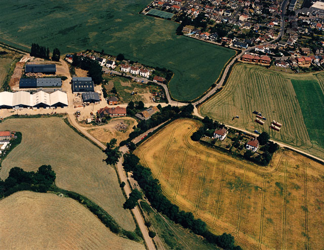
Aerial view of the Salvation Army Farm, Hadleigh. The Salvation Army Farm is part of a wider training centre offered by the Salvation Army. The farm has been a presence in the local landscape since 1891 when William Booth founded the Farm Colony. Today it offers a Tea Room facility for visitors to Hadleigh Country Park and the Farm itself.
Aerial view of the western end of Benfleet Downs. The lower part of the photo is the western end of Benfleet Downs (Hadleigh Country Park). Much of the woodland is Hawthorn scrub which, over the intervening years, has extended and been cut back. The road bordering the downs is St Mary's Road, and Essex Way runs across the top half.


