Halesowen Abbey and Railway Walk
![]()
![]() This circular walk from Halesowen visits the historic Halesowen Abbey before a stroll along the old Halesowen Railway path.
This circular walk from Halesowen visits the historic Halesowen Abbey before a stroll along the old Halesowen Railway path.
The walk starts from the car park in Leasowes Park. The park is one of the area highlights with good footpaths taking you woodland, streams and ponds with lots of wildlife to see on the way. From the car park you can pick up a section of the long distance Monarch's Way and follow the waymarked footpath south to Halesowen Abbey. The ancient site dates back to the 13th century when it was founded by King John. You can follow footpaths past the photogenic abbey ruins to link up with the Illey Way around Illey farm. This footpath runs along the old railway line and can be followed south to visit the remains of the once significant Dowery Dell Viaduct which was dismantled in 1965. Near here there's also the remains of the Elan Aqueduct, another notable feature of the railway which opened in 1878. It closed to passengers in 1919 and then completely closed in 1964.
After viewing the Elan Aqueduct the route then heads north along the dismantled railway towards the abbey. From here you can retrace your footsteps to Leasowes Park.
You can extend the walk by continuing south along the railway path to visit Waseley Hills Country Park.
Halesowen Ordnance Survey Map  - view and print off detailed OS map
Halesowen Open Street Map  - view and print off detailed map
Halesowen OS Map  - Mobile GPS OS Map with Location tracking
Halesowen Open Street Map  - Mobile GPS Map with Location tracking
Walks near Halesowen
- Illey Way - The Illey Way runs along an old railway line from Waseley Hills Country Park to Woodgate near Halesowen
- Leasowes Park - Enjoy an easy stroll around this park and nature reserve in Halesowen near Birmingham
- Dudley Canal - Follow the Dudley Canal from Warren's Hill Park to Leasowes Park on this waterside walk through Blackheath and Halesowen in Birmingham
- Woodgate Valley Country Park - A short route around the delightful Woodgate Valley Country Park in Birmingham
- Monarch's Way - This incredible 615-mile walk approximates the escape route taken by King Charles II in 1651 after being defeated in the Battle of Worcester
- Uffmoor Wood - These attractive woods near Romsley cover over 200 acres with miles of waymarked trails to try
- Warley Woods - This 100 acre park is located in the Smethwick area of Birmingham.
- Netherton Tunnel - This walk explores the northern end of the Netherton Tunnel Canal in Birmingham.
- Waseley Hills Country Park - Waseley Hills is a country park and Local Nature Reserve located on the south western edge of Birmingham
Photos
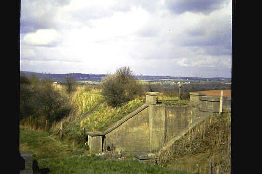
Dowery Dell Viaduct. The impressive Dowery Dell trestle viaduct was a major feature of the Halesowen Railway and it required substantial engineering effort, many relics of which remain in place despite the demolition of the viaduct in 1964. It was 660 feet long and 100 feet high this is one of the stone abutments.
Remains of railway bridge, near Elan Aqueduct. Viewed from site of Halesowen Railway bridge, close to route of Elan Aqueduct. Under former bridge, off to right is cul-de-sac on Oxwood Lane. Half a mile north of here is the site of Dowery Dell viaduct.


