Herstmonceux Castle Walk
![]()
![]() This circular walk explores the grounds of the historic Herstmonceux Castle in East Sussex.
This circular walk explores the grounds of the historic Herstmonceux Castle in East Sussex.
The 15th century moated castle is surrounded by 300 acres of parkland, gardens and woodland which are ideal for a pleasant afternoon stroll. Highlights include the stunning Grade II listed Elizabethan Garden which dates back to 1570, a photogenic Georgian style folly, bluebell woods and the pretty wildflower meadow.
Postcode
BN27 1RN - Please note: Postcode may be approximate for some rural locationsHerstmonceux Castle Ordnance Survey Map  - view and print off detailed OS map
Herstmonceux Castle Open Street Map  - view and print off detailed map
Herstmonceux Castle OS Map  - Mobile GPS OS Map with Location tracking
Herstmonceux Castle Open Street Map  - Mobile GPS Map with Location tracking
Pubs/Cafes
The on site Chestnuts Tea Rooms serve a delicious range of pastries, hot and cold light lunches and sandwiches. You could sit outside an enjoy a cream tea under the ancient Chestnut trees after which the tea rooms are named.
Dog Walking
Dogs on leads are welcome in the grounds of the castle.
Further Information and Other Local Ideas
To continue your walking pick up the 1066 Country Walk and follow it to Battle Abbey and Pevensey Castle. Following the waymarked trail south will take you along Hurst Haven to the Pevensey Level Nature Reserve before coming to the castle.
Just to the west you can pick up the Hailsham Walk and visit another local historic highlight at Michelham Priory. The former Augustine Priory dates from the 13th century and includes some original buildings which are Grade I and Grade II listed.
For more walking ideas in the area see the Sussex Walks page.
Cycle Routes and Walking Routes Nearby
Photos
Herstmonceux Castle and moat. Work started on this brick castle in 1441, brick was an unusual material for a castle due it's weakness over stone, hence it was more of a fortified house than a true castle. In 1776 the interior was ripped out and sold, so until 1912 only the outer walls remained, then the interior was rebuilt. The castle is now owned by Queen's University of Ontario, Canada, they use it as an International Study Centre.
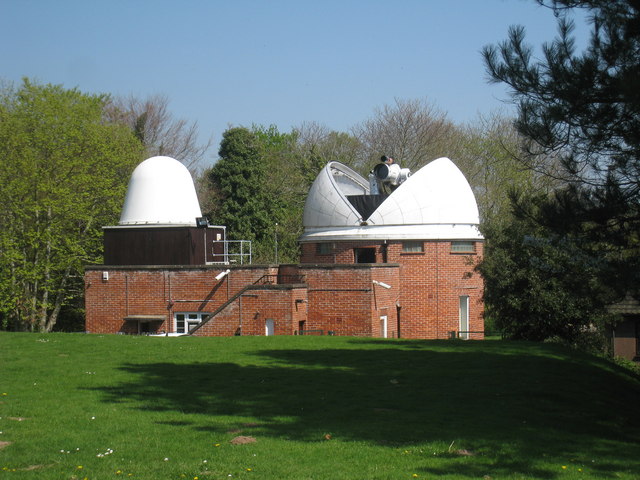
Observatory. The Royal Observatory was founded by King Charles II at Greenwich in 1675. Observing conditions at Greenwich deteriorated following the urban growth of London, and plans were made in the early 20th century to relocate the observatory to a rural location with clearer, darker skies. The relocation of the observatory took place over a decade, and was complete by 1957. The institution at Herstmonceux Castle was known as the Royal Greenwich Observatory, where it remained until 1988, when the observatory relocated to Cambridge.


