How Hill Walks
![]()
![]() This walk takes you through the area around How Hill House in the Norfolk Broads. The house includes lovely parkland and gardens with riverside paths along the River Ant which runs past the site. The area is also a nature reserve so keep your eyes peeled for a wide variety of birds and insects on your visit. You can take a trip on the Electric Eel boat and look out for marsh harriers, dragonflies and butterflies as you make your way along the river.
This walk takes you through the area around How Hill House in the Norfolk Broads. The house includes lovely parkland and gardens with riverside paths along the River Ant which runs past the site. The area is also a nature reserve so keep your eyes peeled for a wide variety of birds and insects on your visit. You can take a trip on the Electric Eel boat and look out for marsh harriers, dragonflies and butterflies as you make your way along the river.
The walk starts at the How Hill car park just to the west of the pretty village of Ludham. From here you can pick up footpaths heading around the beautiful gardens. These include herbaceous borders, a walled garden and a rose garden with lots of pretty butterflies to see in the summer months. There's also a secret garden with stunning azaleas and rhododendrons to see in May and June.
The route then leads you to the river at Turf Fen. You can then follow a nice riverside path south along the River Ant for a couple of miles to Ludham Bridge and Mill. Here you'll find a riverside cafe and a picturesque boatyard. The trail then returns to the car park on the same footpaths.
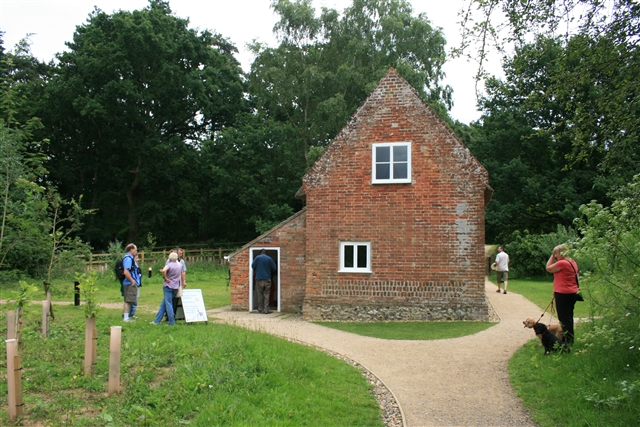
On the way you'll pass the Toad Hole Cottage Museum where you can find out about the life of a marsh man in bygone days in the Broads. It's a quaint little spot right next to the river.
Postcode
NR29 5PG - Please note: Postcode may be approximate for some rural locationsPlease click here for more information
How Hill Ordnance Survey Map  - view and print off detailed OS map
How Hill Open Street Map  - view and print off detailed map
How Hill OS Map  - Mobile GPS OS Map with Location tracking
How Hill Open Street Map  - Mobile GPS Map with Location tracking
Pubs/Cafes
There's a delightful tea room at the house where you can enjoy refreshments after your walk. They sell a good range of meals and snacks which you can enjoy on the outdoor balcony with views over the gardens.
At Ludham Bridge you'll find some stores and the Wayfarers Cafe. It's in a lovely spot, next to the river, with plenty of outdoor seating in the garden area.
Dog Walking
The woodlands, parkland, gardens and river paths make for a lovely dog walk. You are requested to keep them on leads through the gardens of How Hill House though. The Wayfarers Cafe mentioned above is also dog friendly.
Further Information and Other Local Ideas
A few miles south of Ludham you'll find Ranworth Broad. There's some lovely waterside trails and a Wildlife Centre with lots of information about the various birds you can see here. In the village there's also the noteworthy Church of St Mary, known as the Cathedral of the Broads. You can climb the tower of the 16th century church for excellent views over the area.
A few miles to the east you'll find the pretty village of Potter Heigham where you can enjoy a walk to the adjacent Hickling Broad. There's also some easy trails along the River Thurn here.
Head north west and you can pick up the Bure Valley Path and enjoy riverside walks to Coltishall and Wroxham. Here you can also pick up the Hoveton Walk which visits the nearby Hoveton Hall. The 19th century house includes some beautiful grounds with stunning gardens, a pretty lake and popular snowdrop walks in February.
Just to the south west there's the worthy village of Horning where there are some nice footpaths around the Bure Marshes Nature Reserve, a fine riverside pub and a foot ferry service to take you over the Bure. Salhouse Broad can also be accessed in this area.
For more walking ideas in the area see the Norfolk Broads Walks page.
Cycle Routes and Walking Routes Nearby
Photos
How Hill House. It includes The Norfolk Broads Study Centre, run by the How Hill Trust. The house was the family home of Christopher Boardman who won a gold medal in sailing in the 1936 Olympic Games. As a gold medallist he was presented with an oak sapling which he planted at How Hill.
Moorings. These recently renewed moorings are on the River Ant between Ludham Bridge and Barton Broad.
Further to the right is How Hill House.
The tall mast at the end of the moorings belongs to Pleasure Wherry Hathor.
Toad Hole Cottage. This tiny cottage, once home to a marshman and his family, is maintained as a museum by the Broads Authority.


