Kimmeridge Bay to Chapmans Pool
![]()
![]() This circular walk takes you along the South West Coast Path to two noteable highlights on the Jurassic Coast.
This circular walk takes you along the South West Coast Path to two noteable highlights on the Jurassic Coast.
The beautiful Kimmeridge Bay is part of the Purbeck Marine Wildlife Reserve. On the beach you will find a number of rock-pools where you can look out for a variety of marine wildlife. From here you can head east along the South West Coast Path to the lovely Chapman's Pool. The walk passes Clavell Tower and Egmont Point where there is a pretty waterfall.
From Chapman's Pool the return leg climbs through the countryside above Kimmeridge. You'll pass Smedmore Hill and Swyre Head before returning to Kimmeridge. The views on this elevated section of the coast and countryside are simply stunning.
Just to the west of Kimmeridge you will find the Lulworth Range Walks. The military owned area is only open to the public at certain times (most weekends). There are some lovely walking trails here with climbs to Povington Hill (191 m) and the range's highest point, Ridgeway Hill (199 m) with fabulous views over the Purbeck Hills and the coastline. The area includes the deserted village of Tyneham. The village was abandoned during the second world war when all the residents were told to leave so the area could be used for military training. Today you can enjoy a stroll around the ruined buildings and visit the associated museum.
You can also reach the bay by following The Hardy Way from Wareham or Corfe Castle.
Postcode
BH20 5PF - Please note: Postcode may be approximate for some rural locationsKimmeridge Bay to Chapmans Pool Ordnance Survey Map  - view and print off detailed OS map
Kimmeridge Bay to Chapmans Pool Open Street Map  - view and print off detailed map
Kimmeridge Bay to Chapmans Pool OS Map  - Mobile GPS OS Map with Location tracking
Kimmeridge Bay to Chapmans Pool Open Street Map  - Mobile GPS Map with Location tracking
Pubs/Cafes
Head to the delightful Clavell’s Restaurant in the picture box village of Kimmeridge for refreshments after your walk. There's a fine menu and a nice outdoor seating area to relax in during the summer months. You can find the pub at postcode BH20 5PE.
Further Information and Other Local Ideas
At Houns-Tout you could pick up the Kingston Walk which starts from the nearby village. Here you'll find some splendid Purbeck stone cottages, a wonderful old pub and a significant church known as 'The Cathedral of the Purbecks'.
Head a few miles north west and you could visit the historic Lulworth Castle. The castle dates back to the 17th Century and includes some beautiful grounds and gardens. Near here there's the Winfrith Newburgh Heath and Tadnoll Nature Reserves. The reserves include miles of peaceful heathland trails with lots of wildlife and a splendid viewpoint.
For more walking ideas in the area see the Dorset Walks page.
Cycle Routes and Walking Routes Nearby
Photos
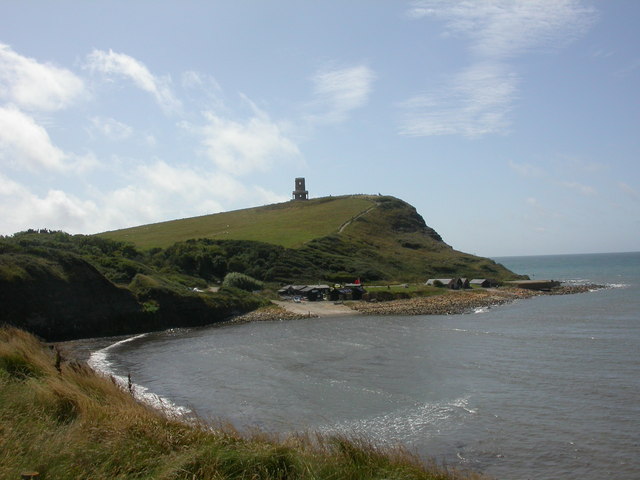
Kimmeridge Bay. The eastern end of the bay, as seen from the coastal footpath; interpretation centre and range warden (with red flag flying) at beach level, and Clavell Tower on the top of the hill.
Kimmeridge Bay, cliff. Cliffs comprised of shale, clay & dolomite; directly above are boundary posts showing the original position of Clavell Tower, right on the cliff edge. The foreshore can only be accessed at low tide.
Clavell Tower repositioned. The tower has now been superbly rebuilt and is available as holiday accommodation with unparalleled views


