Lulworth Range Walks
![]()
![]() This circular walk in Dorset visits the deserted village of Tyneham before heading along the coast at Brandy Bay and Worbarrow Bay. It is part of the Lulworth Range Walks in the Purbeck Hills near Kimmeridge Bay. The range walks are open most weekends but check the website below for more details.
This circular walk in Dorset visits the deserted village of Tyneham before heading along the coast at Brandy Bay and Worbarrow Bay. It is part of the Lulworth Range Walks in the Purbeck Hills near Kimmeridge Bay. The range walks are open most weekends but check the website below for more details.
The walk starts from the car park in Tyneham Village with its interesting ruined buildings. You then head to the South West Coast Path where there are lovely views along the coast to Brandy Bay, Horbarrow Bay and Kimmeridge Bay. The route continues west along the coast to Worbarrow Tout and the beautiful Worbarrow Bay. A climb to the Iron Age Hill Fort at Flower Barrow is quite challenging but you are rewarded with more magnificent coastal views. The route continues to Whiteway Hill before descending back into Tyneham.
The area is owned by the military and while this restricts access it does encourage a wide variety of interesting flora and fauna. Look out for rare flowers, fungi and insects as you make your way through this lovely area.
The walk can easily be extended by heading east to the nearby Povington Hill (191 m) and the range's highest point, Ridgeway Hill (199 m). Here you will find the pretty Stonehill Downs Nature Reserve where there is a variety of birdlife to look out for.
Postcode
BH20 5DE - Please note: Postcode may be approximate for some rural locationsPlease click here for more information
Lulworth Range Walks Ordnance Survey Map  - view and print off detailed OS map
Lulworth Range Walks Open Street Map  - view and print off detailed map
Lulworth Range Walks OS Map  - Mobile GPS OS Map with Location tracking
Lulworth Range Walks Open Street Map  - Mobile GPS Map with Location tracking
Pubs/Cafes
Just to the north west of the site you'll find the village of East Lulworth. Here you can enjoy some post walk refreshments at The Weld Arms. The 17th century inn has a very good menu and a lovely large garden area for warmer days. You can find them at postcode BH20 5QQ for your sat navs.
Further Information and Other Local Ideas
For an alternative route see the Tyneham Walk which starts from the same car park. This route explores the area east of the village, climbing to the viewpoints at Povington Hill and Tyneham Cap.
Head a few miles to the west and you could visit the historic Lulworth Castle. The castle dates back to the 17th Century and includes some beautiful grounds and gardens. Near here there's the Winfrith Newburgh Heath and Tadnoll Nature Reserves. The reserves include miles of peaceful heathland trails with lots of wildlife and a splendid viewpoint.
For more walking ideas in the area see the Dorset Walks page.
Cycle Routes and Walking Routes Nearby
Photos
Eastern end of the Lulworth range walk. The cabin on the left houses an MoD sentry when the Lulworth tank ranges are closed to the public. It marks the eastern end of the range walk along the ridgeway. The small stone marker in the foreground on the right is a modern milestone. In the distance a red warning flag flies at the car park and picnic area, with Grange Hill beyond.
View along the Ridge, Tyneham Cap. This drystone wall follows the top of the Purbeck limestone ridge, with one of the Lulworth Range Walks following it on the southern (right) side. In the far distance is the Purbeck Hills chalk ridge, and the ruins of Corfe Castle are just about visible through the haze.
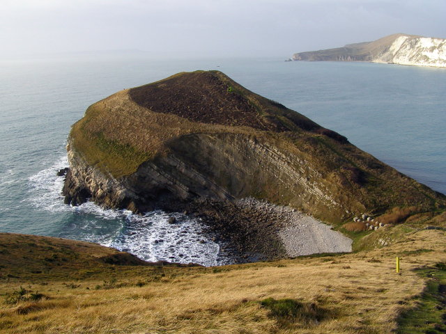
Pondfield Cove and Worbarrow Tout Looking down into Pondfield Cove from the cliff path at Worbarrow. The isthmus beyond is called Worbarrow Tout - "tout" meaning lookout place. The northwards dip of the rock strata is obvious in the west and east cliffs of the cove. The cove itself has formed as the sea has nibbled along a north-south fault. Eventually the sea will break through the gap to Worbarrow Beach on the far side, leaving Worbarrow Tout as an island - a larger version of the Mupe Rocks on the far side of the bay (just about visible in the distance). The Isle of Portland is just visible in the hazy far distance. The concrete blocks at the head of the cove are anti-tank defences, relics from the Second World War.
Ruined cottage in Tyneham's eery abandoned village. This cottage is in the terrace to the south of St Mary's Church. The occupants of the house were evacuated from the village in 1943, along with the rest of the villagers, when the area was included in an extension of the ranges attached to Lulworth Camp. After the war the range was kept open and the villagers could not return. The building has been 'made safe' so that the public can go inside when the village is open.


