Loggerheads Country Park
![]()
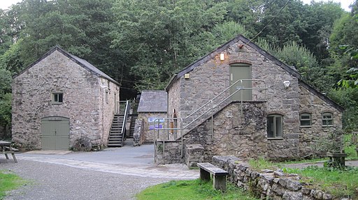
![]() Explore the beautiful Clwydian Range and Dee Valley in this stunning country park in Mold. Dramatic limestone cliffs, wooded gorges and secluded grasslands dominate the scenery while the River Alyn also runs through the park. Highlights include the walkway over the Devil's Gorge - a popular spot for abseilers. There are also several caves to explore, a restored water mill and the pretty riverside tea gardens.
Explore the beautiful Clwydian Range and Dee Valley in this stunning country park in Mold. Dramatic limestone cliffs, wooded gorges and secluded grasslands dominate the scenery while the River Alyn also runs through the park. Highlights include the walkway over the Devil's Gorge - a popular spot for abseilers. There are also several caves to explore, a restored water mill and the pretty riverside tea gardens.
The park contains the Clwydian Range Centre where you will find a wealth of information including details of the way-marked walks in the park. Loggerheads is located just to the west of Mold. Clywd Forest is only about a mile to the west and is a good option if you would like to continue your outing.
You could also climb the splendid Moel Famau for wonderful views over the area.
In nearby Ruthin you can explore the lovely grounds of the medieval Ruthin Castle. There's also nice walks along the River Clwyd to enjoy here.
Postcode
CH7 5LH - Please note: Postcode may be approximate for some rural locationsLoggerheads Country Park Ordnance Survey Map  - view and print off detailed OS map
Loggerheads Country Park Open Street Map  - view and print off detailed map
Loggerheads Country Park OS Map  - Mobile GPS OS Map with Location tracking
Loggerheads Country Park Open Street Map  - Mobile GPS Map with Location tracking
Pubs/Cafes
After your exercise head to the Druid Inn in Llanferres on Ruthin Road (Postcode:CH7 5SN). Here you'll find a tremendous olde worlde atmosphere with low beamed ceilings and in the winter roaring log fires. The pub has a great menu, a nice outdoor seating area with countryside views.
Also on the Ruthin Road is We Three Loggerheads at postcode CH7 5LH. This pub is set in a restored 17th century coaching inn with a traditional bar and a beautiful vaulted restaurant.
Dog Walking
The woodland and river trails are ideal for dog walking so you will probabaly bump into other owners on your visit to the park. The Druid Inn and the We Three Loggerheads pubs mentioned above are also dog friendly.
Further Information and Other Local Ideas
Just a few miles north of the park there's a nice little walk to do at Coed y Felin. There's peaceful woodland here with grassland, birds and wildflowers to enjoy.
The Mold Walk visits the park from the town by following a country lane to the site. It then goes on to climb Moel Famau just to the west. The historic town has some interesting old buildings including a Grade I listed church.
A few miles to the north there's the delightful Coed y Felin Woodland Walk in Hendre. Here you'll find a lovely little woodland nature reserve with bluebells and a wildflower meadow.
The circular walk from the nearby Maeshafn village visits the park, Moel Famau and the ancient fort at Foel Fenlli. You'll also pass the neighbouring village of Cilcain where there's a significant 13th century church and a fine early 19th century pub to see.
For more walking ideas in the area see the Clwydian Range Walks page.


