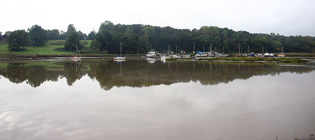
Martlesham Creek
![]()
![]() This circular walk takes you to Martlesham Creek from the little village of Martlesham, near Woodbridge.
This circular walk takes you to Martlesham Creek from the little village of Martlesham, near Woodbridge.
The walk starts in the village where you can pick up the Fynn Valley Walk long distance footpath. Follow it east and it will take you to the creek where you can walk along a waterside trail on the northern side. It will take you to Kyson Point and hill, an area run by the National Trust right next to the mouth of the creek where it meets with the River Deben. It's a picturesque area and one of the highlights of the creek. At the site you'll find a grassy hill, surrounded by wooded belts, sloping down to the saltings and mudflats of the tidal Deben. It's a great area for bird watching with many species visiting the estuary. Look out for egrets, oyster catchers, plovers, teals, little grebes, redshanks, black tailed godwits, and curlews as you make your way along the river.
The route then heads north west to Maidensgrave before picking up a country lane to take you back to Martlesham.
Martlesham Creek Ordnance Survey Map  - view and print off detailed OS map
Martlesham Creek Open Street Map  - view and print off detailed map
Martlesham Creek OS Map  - Mobile GPS OS Map with Location tracking
Martlesham Creek Open Street Map  - Mobile GPS Map with Location tracking
Pubs/Cafes
The Red Lion is a good choice for some post walk refreshments. It's a pub of some note, dating from the 16th century when it was a coaching inn on the old London to Yarmouth turnpike road. Now a Grade II listed country pub it has retained many of its 16th century features, including exposed wooden beams and open fireplace. It's well known for its distinctive Red Lion figurehead which sits on the exterior of the pub. The historic piece was captured in 1672 from a Dutch ship at the Battle of Sole Bay. They have a good menu and can be found at postcode IP12 4RN for your sat navs.
Dog Walking
The creek and the woodland trails around Kyson point are popular with dog walkers. The Red Lion mentioned above is also dog friendly.
Further Information and Other Local Ideas
The Waldringfield Walk starts from the nearby village and visits Martlesham before heading into Woodbridge for a riverside stroll along the Deben. The village is worth a visit as it's nicely located next to the river and includes a noteworthy 14th century church and a very fine quayside pub.
Also close to the creek is the interesting Sutton Hoo ancient burial ground. The National Trust owned estate has some nice trails through woodland and along the river.
On the opposite side of the river you can pick up the Ramsholt Walk. This will take you along the eastern side of the river to Methersgate Quay. In Ramsholt there's a pretty quay, a beach and a splendid riverside pub in what is a delightful remote, unspoilt spot.
For more walking ideas in the area see the Suffolk Walks page.
Cycle Routes and Walking Routes Nearby
Photos
Dog Walkers at the woodland area at Kyson Point. Looking out of the woods at Kyson Point to the start of the riverside path.


