Milton Keynes Boundary Walk
![]()
![]() Enjoy rivers, canals, woodland and beautiful countryside on this walk around the boundary of Milton Keynes.
Enjoy rivers, canals, woodland and beautiful countryside on this walk around the boundary of Milton Keynes.
There's nice views of the Grand Union Canal, the Great Ouse river and the countryside of Bedfordshire, Buckinghamshire and Northamptonshire.
You'll also enjoy long woodland sections through Rushmere Country Park, Aspley Woods and Bow Brickhill Woods near Woburn Sands. There's good wildlife opportunities here with Muntjac Deer and Fallow Deer to look out for.
Milton Keynes Boundary Walk Ordnance Survey Map  - view and print off detailed OS map
Milton Keynes Boundary Walk Open Street Map  - view and print off detailed map
Milton Keynes Boundary Walk OS Map  - Mobile GPS OS Map with Location tracking
Milton Keynes Boundary Walk Open Street Map  - Mobile GPS Map with Location tracking
Pubs/Cafes
On the walk stop for refreshments at the noteworthy Barley Mow in Cosgrove. Housed in a lovely 17th Century building the pub boasts a large beer garden to relax in during the summer months. You can also see the notweworthy Cosgrove aqueduct here. The cast iron trough structure carries the Grand Union Canal over the River Great Ouse, just to the south east of the village.
The delightful village of Turvey is another good choice for pit stop. Here you could pay a visit to the noteworthy Three Fyshes. The friendly country pub does good food and is in a great location next to the river on the medieval Turvey Bridge. There's more history too with the building dating back to the 15th century and the inn back to 1624. Inside there's a charming olde worlde interior with a flagstone floor and inglenook fireplace. Outside there's a lovely seating area with views over the river. You can find them on Bridge Street with a postcode of MK43 8ER for your sat navs.
Further Information and Other Local Ideas
The Turvey Circular Walk uses part of the trail to explore the area around the historic village. The picturesque village includes a medieval bridge, a 17th century abbey and views of the River Great Ouse.
For more walking ideas in the area see the Bedfordshire Walks, the Buckinghamshire Walks and the Northamptonshire Walks pages.
Cycle Routes and Walking Routes Nearby
Photos

The walk south on the Milton Keynes Boundary Walk in towards Buttermilk Wood.

Wheat field and field boundary towards Astwood. Coppershole Spinney on right

These friendly cattle are grouped across the footpath near Ravenstone.

Turvey House viewed from Turvey Bridge. This view taken from the north side of Turvey Bridge shows Turvey House in its parkland setting, with one channel of the River Great Ouse flowing northwards in the foreground. The notable 11-arch bridge itself dates from the medieval period and is the oldest crossing of the River Great Ouse in Bedfordshire. The village itself is well worth exploring with a 15th century inn and an early 17th century abbey to see.

Grafton Regis. A view from the bridge which takes the Milton Keynes Boundary Walk over the Grand Union Canal.

The trail by a weir on the Ouse

Crossing farmland near Castlethorpe in summer.

Greensand Ridge Walk. To the south is Stockgrove Park and further along the footpath Greensand Ridge & the Milton Keynes Boundary Walk join together along the same path for a time to cross the A5 and head up past Aspen Farm.
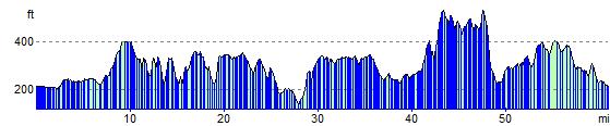
Elevation Profile