Otterbourne River Walk
![]()
![]() This Hampshire based village is located near Winchester and Eastleigh in the Itchen Valley.
This Hampshire based village is located near Winchester and Eastleigh in the Itchen Valley.
This walk takes you along the River Itchen to neighbouring Shawford which lies just to the north. It uses part of the Itchen Way, a waymarked long distance trail runnning through the area.
The walk starts in the village and heads east past Otterbourne Hill and Otterbourne Park Wood. You then meet up with the river near Brambridge House where there is a fine old manor house and a pretty weir on the river. The route then continues north along the river path to the neighbouring village of Shawford.
You can extend the walk by continuing north into Winchester where you can visit the historic cathedral and enjoy a climb to the splendid viewpoint at St Catherine's Hill.
Postcode
S021 2HW - Please note: Postcode may be approximate for some rural locationsOtterbourne Ordnance Survey Map  - view and print off detailed OS map
Otterbourne Open Street Map  - view and print off detailed map
Otterbourne OS Map  - Mobile GPS OS Map with Location tracking
Otterbourne Open Street Map  - Mobile GPS Map with Location tracking
Walks near Otterbourne
- Itchen Way - Follow the River Itchen from its mouth at Woolston to its source near Hinton Ampner on this beautiful waterside walk
- Lakeside Country Park - Enjoy 60 acres of lakes, wet meadow and woodland located between Eastleigh and Southampton
- Itchen Valley Country Park - Explore 440 acres of parkland in this attractive country park in Southampton
- Stoke Park Woods - These woods in Eastleigh have some nice cycling and walking trails to try
- Winchester Circular Walk - This circular walk takes you around the city of Winchester in Hampshire
- St Catherine's Hill Winchester - Climb this small hill in Winchester for fine views over the town, the River Itchen and the surrounding countryside of the South Downs
- Eastleigh to Winchester River Itchen Walk - This popular riverside walk takes you from Eastleigh to Winchester along a section of the Itchen Way
- Winnall Moors Nature Reserve - Enjoy a short stroll around this pretty nature reserve in Winchester
- Ampfield Woods - This large woodland area near Hursley has miles of walking trails to try
- St Gile's Hill Winchester - This short walk climbs to a fine viewpoint above the city of Winchester
- Hockley Viaduct - This circular walk in Winchester visits the historic Hockley Railway Viaduct
- Itchen Abbas - This pretty little Hampshire based village is located in a lovely spot on the River Itchen near to Winchester
- Cheriton - This pretty Hampshire based village is home to a lovely National trust property, a 13th century church, prettty thatched cottages and some fine country views
- Hinton Ampner - Explore the beautiful gardens surrounding this stately home near New Alresford in Hampshire
Pubs/Cafes
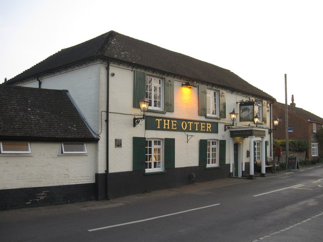
The Otter pub dates back 300 years and sits in a lovely location overlooking the village green. They serve a fine Sunday roast and have a fine garden area to sit out in on warmer days. You can find them at Boyatt Lane with postcode S021 2HW. The pub is also dog friendly if you have your canine friend with you.
Photos
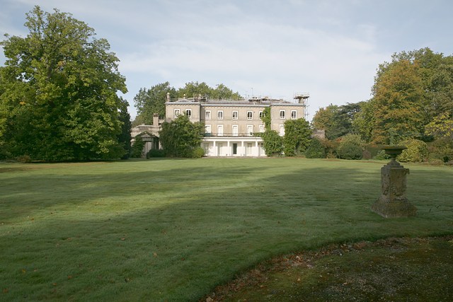
Brambridge House. Looking W. This house has been converted into flats. At the time of photo the roof is being repaired. Brambridge Garden Centre is located across the road in what used to be the walled kitchen garden of this house. There is an avenue of trees behind the photographer, but the drive between them no longer exists.


