Penkridge Walk - Canal and Country
![]()
![]() This Staffordshire based market town is in an ideal spot for exploring the countryside and woodland of the Cannock Chase AONB. There's also some nice waterside walking along the canal towpath and the River Penk which run through the town. The historic town itself is also worth exploring with a Grade I listed medieval church, the Penkridge Railway Viaduct and the Old Market Square to see.
This Staffordshire based market town is in an ideal spot for exploring the countryside and woodland of the Cannock Chase AONB. There's also some nice waterside walking along the canal towpath and the River Penk which run through the town. The historic town itself is also worth exploring with a Grade I listed medieval church, the Penkridge Railway Viaduct and the Old Market Square to see.
This walk from Penkridge takes you along the Staffordshire and Worcestershire Canal and the Staffordshire Way to one of the highlights of the area at the nearby Cannock Chase Country Park.
The walk starts in the town centre where you can pick up the Staffordshire Way and follow the waymarked footpath north along the canal towpath. At Parkgate Lock you turn north east to head through Teddesley Hall Park. This was the site large Georgian English country house which has since been demolished, though traces of the hall, gardens and park still remain. The trail passes through the old park where there's picturesque pools, woodland and farmland.
After passing through the park you will come to the little village of Bednall before climbing Sycamore Hill and finishing in the Oldacre Valley in Cannock Chase Country Park.
Penkridge Ordnance Survey Map  - view and print off detailed OS map
Penkridge Open Street Map  - view and print off detailed map
Penkridge OS Map  - Mobile GPS OS Map with Location tracking
Penkridge Open Street Map  - Mobile GPS Map with Location tracking
Pubs/Cafes
The Cross Keys is in a nice location next to the canal in the town. If the weather's good you can sit outside and enjoy a drink while watching the boats, ducks and swans go by. You can find them at Filance Lane with a postcode of ST19 5HJ for your sat navs.
Dog Walking
The open country and woodland trails on the route are ideal for dog walking. The Cross Keys mentioned above is also dog friendly.
Further Information and Other Local Ideas
If you head west along the Staffordshire Way it will take you to Preston Vale, Whiston, Bickford, Mitton, Lapsey and Belvide Reservoir. There's more nice waterside trails around this pretty lake.
If you follow the canal north it will take you into Stafford via Acton Trussell. Here you can visit the Stafford Castle and enjoy walks along the River Sow. Follow the towpath south and you can visit the Galley Reservoirs, Calf Heath Reservoir and Wolverhampton.
Near Cannock Chase Country Park you can pick up several long distance trails including the Two Saints Way, the Heart of England Way and the Sabrina Way. Milford Common is also nearby and has a series of decent trails to try.
If you follow the canal south from the town it will take you to the Gailey Reservoirs, the home of South Staffordshire Sailing Club.
For more walking ideas in the area see the Staffordshire Walks page.
Cycle Routes and Walking Routes Nearby
Photos
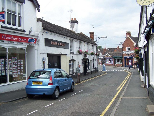
Market Street, Penkridge. The Horse & Jockey Inn on the left goes back to at least 1754. Its name has been linked to the Penkridge Races even though they were organized from the Littleton Arms. As it is the closest inn to the Horsefair, site of “the greatest horsefair in the world for horses of value” (Daniel Defoe, 1724) and would have served the men who looked after them (known as jockeys in the 18th century) an alternative explanation might be more likely.
The Littleton Arms. Situated on the corner of St. Michael’s Square, the inn rests on walls 2 feet 6 inches wide, showing it was built on the cellars of the medieval Collegium guest house. Built in the early 1790s by Sir Edward Littleton as a replacement for the King’s Arms, its first sign went up in 1794. Built of bricks of Penkridge clay and of Teddesley oak by local craftsmen it became the centre of village life, hosting great balls, auctions, estate rent days and the magistrates’ court.


