Porthmadog to Portmeirion Walk
![]()
![]() This walk takes you from Porthmadog to the delightful Italian style village of Portmeirion on the other side of the estuary of the Afon Glaslyn. It's a lovely area with the estuary full of birds such as Oystercatchers, redshanks and curlews are common and, in summer, there are flocks of sandwich terns.
This walk takes you from Porthmadog to the delightful Italian style village of Portmeirion on the other side of the estuary of the Afon Glaslyn. It's a lovely area with the estuary full of birds such as Oystercatchers, redshanks and curlews are common and, in summer, there are flocks of sandwich terns.
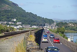
You can start the walk from Porthmadog Harbour on the Brittania Bridge. There's nice views here down to Llyn Bach to the north and the harbour to south. From here you can pick up a footpath running along the Porthmadog Cob with views of the Ffestiniog Railway which also passes across the estuary here. The popular heritage railway is roughly 13 1⁄2 miles (21.7 km) long and runs from the harbour at Porthmadog to the slate mining town of Blaenau Ffestiniog, travelling through forested and mountainous scenery.
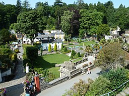
The path then passes Boston Lodge Halt railway station before following footpaths south into Portmeirion. The picturesque Italian style village has some delighful architecture, pretty gardens and coastal views. There's also some nice woodland trails through the 'Wild Wood' to the south west of the village.
To continue your walking in the area try our Circular Walk around Porthmadog which visits the wonderful Black Rocks Sands beach at Morfa Bychan and climbs to Moel y Gest for great views over the area.


