Rugeley Walks
![]()
![]() This Staffordshire based town has some nice waterside trails along the river and canal which run through the area. It's also very near to the splendid Cannock Chase AONB, where there's miles of walking and cycling opportunites.
This Staffordshire based town has some nice waterside trails along the river and canal which run through the area. It's also very near to the splendid Cannock Chase AONB, where there's miles of walking and cycling opportunites.
This walk from the town takes you along the Trent and Mersey Canal to the wonderful Shugborough Hall just to the north.
The walk starts on the eastern side of the town where you can pick up the canal towpath. Follow it north and it will take you through Colwich to Little Haywood and Great Haywood where you will find Shugborough Hall. The historic hall is one of the local highlights with an expansive area of woodland and parkland to explore.
After exploring the hall the route returns to the town on the same paths which include a section along the waymarked Staffordshire Way.
Rugeley Ordnance Survey Map  - view and print off detailed OS map
Rugeley Open Street Map  - view and print off detailed map
Rugeley OS Map  - Mobile GPS OS Map with Location tracking
Rugeley Open Street Map  - Mobile GPS Map with Location tracking
Walks near Rugeley
- Cannock Chase Country Park - This huge country park has 3000 acres of cycling and walking trails to explore
- Birches Valley - This circular walk visits the Birches Valley area of the Cannock Chase AONB.
- Trent and Mersey Canal - Follow the Trent and Mersey Canal through Derbyshire, Staffordshire and Cheshire on this long distance waterside walk
- Blithfield Reservoir - This large reservoir in the Blithe Valley has three nice colour coded walking trails to try
- Abbots Bromley - This fine Staffordshire village is a worthy place to explore
- Shugborough Park - This circular walk uses public footpaths and the Staffordshire Way to take you around Shugborough Park in Great Haywood
- Millennium Way - Travel across the width of Staffordshire and visit Stafford, Colwich, Rugeley, Yoxall and Barton Under Needwood on this splendid walk
- Staffordshire Way - Travel through Staffordshire, Cheshire, Derbyshire, Worcestershire and enjoy canals, lakes, country parks and a series of pretty towns and villages
Pubs/Cafes
The Ash Tree is in a great location next to the canal. There's a nice garden area where you can enjoy a meal with a view of the water. You can find them on Armitage Road at postcode WS15 1PL for your sat navs.
Dog Walking
The canal paths make for a fine dog walk and the Ash Tree mentioned above is also dog friendly. The woodland trails in Cannock Chase are also ideal for a local dog walk.
Further Information and Other Local Ideas
Just to the west of the town you will find the popular Cannock Chase Country Park. There's miles of walking and mountain bike trails to enjoy here. Only a couple of miles to the south west there's the lovely Birches Valley area. The well organised site includes a visitor centre, car park, walking paths, mountain bike trails, a Go Ape adventure park and a series of delightful tranquil pools.
Heading south east along the canal will take you to the historic Hawkesyard Hall which dates from the 18th century.
For more walking ideas see the Cannock Chase Walks and the Staffordshire Walks pages.
Photos
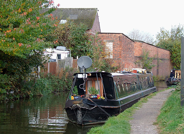
Autumn colours on the canal. This is the Trent and Mersey canal, built 1766-1777 under the supervision of James Brindley. It has acted as a eastern boundary to the expansion of Rugeley.
Trent and Mersey view through the town. The Trent and Mersey canal, fully opened by 1777, has acted as a boundary to the expansion of Rugeley to the north-east. These canal-side cottages, ideal for people who prefer small gardens, are in Anson Mews. Some of it seems to be restored old housing, though the end one is more modern, and the far buildings are recent. Just in case your boat doggy or moggie is ill, there is a vet's practice in the mews, as well as a large supermarket nearby.
The old factory units here in Mill Lane will probably be redeveloped before long, and canal-side housing seems to be a popular use for such sites.
Both bridges are (or were) railway bridges taking the lines to the power station, yet the closer (more modern) one has become disused. Neither has an original canal bridge number, as they were built after the canal, which dates from as long ago as 1777 (it having been given permission to start construction in 1766).
The Essex Bridge (part) at Shugborough, Staffordshire. The stone packhorse bridge across the River Trent was built in 1550 by the Earl of Essex for Queen Elizabeth I so she could go hunting near the village. It has low parapets to avoid impeding the wide loads on the horses. Originally it had 40 arches, fourteen of which remain.
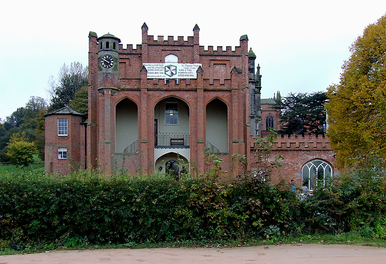
Hawkesyard Hall. Nathaniel Lister, (poet and author, Member of Parliament for Clitheroe and uncle of Baron Ribblesdale) had the house built in the Gothic Revival style in about 1760. Josiah Spode IV, greatgrandson of Josiah Spode bought the estate in about 1840 and the house was much altered and extended. At this time it was known as Spode House. The present owners, who have converted this superb Grade II listed building into offices and a conference centre.


