Saxmundham Walks
![]()
![]() This Suffolk based market town has some nice trails to try through the valley of the River Fromus. The wonderful Suffolk Coast and Heaths AONB is also not far away and provides some of the best walking trails in the area. In the town there's also some fine old buildings including a series of Elizabethan cottages and a church dating back to the 11th century.
This Suffolk based market town has some nice trails to try through the valley of the River Fromus. The wonderful Suffolk Coast and Heaths AONB is also not far away and provides some of the best walking trails in the area. In the town there's also some fine old buildings including a series of Elizabethan cottages and a church dating back to the 11th century.
This walk from the village follows the East Suffolk Line Walks south to visit Snape Maltings.
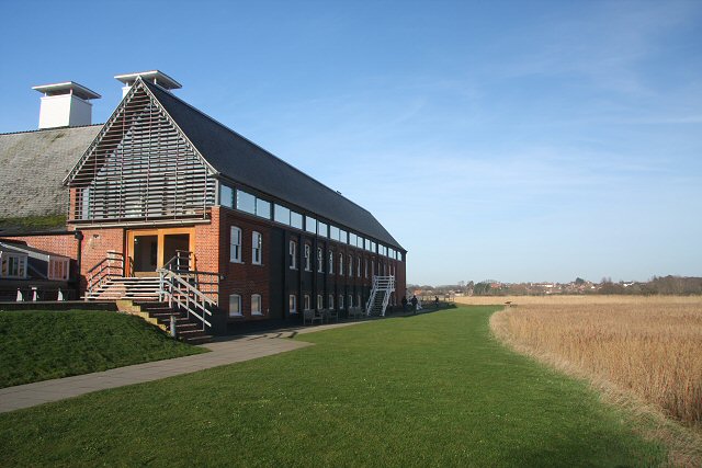
The walk starts in the village and heads south to Benhall Green and Snape Watering. You continue along Hulver Lane and Gromford Lane before arriving at Snape. Here you'll find the Maltings nature reserve which includes reedbeds, wet woodland and marshland with lots of wildlife to see.
The area also includes an expansive arts complex on the banks of the River Alde. It's best known for its concert hall, which is one of the main sites of the annual Aldeburgh Festival. The complex also includes shops, galleries and restaurants where you can enjoy refreshments before the return leg.
The walk can be extended by continuing south to Blaxhall Common and Tunstall Forest where there are miles of good cycling and walking trails. The Suffolk Coast Path can also be picked up in this area. If you follow it east it will take you to the coast at Aldeburgh and Thorpeness.
Saxmundham Ordnance Survey Map  - view and print off detailed OS map
Saxmundham Open Street Map  - view and print off detailed map
Saxmundham OS Map  - Mobile GPS OS Map with Location tracking
Saxmundham Open Street Map  - Mobile GPS Map with Location tracking
Walks near Saxmundham
- East Suffolk Line Walks - Follow the 'East Suffolk Line' railway from Ipswich to Lowestoft on this splendid walk through the Suffolk countryside
- Aldeburgh to Snape Maltings - This walk visits the lovely Snape Maltings Nature Reserve from the coastal town of Aldeburgh in Suffolk
- Tunstall Forest - This large forest in Suffolk has miles of good footpaths and a 10 mile red graded single-track mountain bike trail
- Orford Ness - Follow the walking trails around this beautiful nature reserve on the Suffolk Coast
- Rendlesham Forest - Rendlesham Forest is probably most famous for reported UFO sightings in 1980 but it is also a great place for cycling and walking
- Suffolk Coast Path - A walk along the beautiful Suffolk coast from Felixstowe to Lowestoft
- Aldeburgh to Thorpeness - A circular walk from Aldeburgh to Thorpeness, taking in the Suffolk Coast, the wonderful Thorpeness Meare and the North Warren RSPB reserve.
Start from Aldeburgh at the Fort Green car park on the front - Aldeburgh - The coastal Suffolk town of Aldeburgh is a lovely place for walkers
- Framlingham Castle - This walk visits the 12th century Framlingham Castle and follows the public footpaths surrounding the attractive Suffolk based market town
- Westleton - This Suffolk village is a fine place to start a walk
- Dunwich Forest - This large forest is located in the Suffolk Coasts and Heaths Area of Outstanding Natural Beauty in the village of Dunwich
- Dunwich Heath - This beautiful coastal heathland is a wonderful place for a peaceful circular walk
- Dunwich to Walberswick Walk - This circular walk takes you from Dunwich to Walkberswick on the Suffolk coast
- Halesworth - This Suffolk based market town has some nice trails along the Blyth River
- Iken - This walk explores the area around the Suffolk village of Iken
- Leiston - This East Suffolk based town is located near the coast and the towns of Aldeburgh and Saxmundham.
- Aldringham - This Suffolk based village is located just south of Leiston in the Blything Hundred area of the county.
Pubs/Cafes
The Poacher's Pocket is located just to the north of the town centre. The friendly pub does a fine Sunday lunch at reasonable prices. You can find them on Rosemary Lane at postcode IP17 2QS for your sat navs.
Dog Walking
The river and country trails make for a fine dog walk. The Poacher's Pocket mentioned above is also dog friendly.
Further Information and Other Local Ideas
To the west there's some nice trails to follow around the grounds of the historic Framlingham Castle.
The Iken Walk can be picked up just south of Snape village at the Iken Cliff car park. It will take you east along the river to visit the splendid old St Botolph's Church. The ancient place of worship includes a part thatched roof and an ancient nave dating back to the 12th century.
A few miles to the east is the town of Leiston where you can explore the fascinating ruins of Leiston Abbey. The English Heritage owned site dates back to the 12th century and is considered one of the historic highlights of the area. Just to the south of Leiston is the neighbouring village of Aldringham where you can explore the RSPB's Aldringham Walks. The wildlife rich conservation area includes a number of footpaths taking you to heathland, woodland and scrub.
For more walking ideas in the area see the Suffolk Walks page.


