Stokenchurch Walks - Near and Around
![]()
![]() This Buckinghamshire based village has some lovely trails to follow through the surrounding Chilterns countryside. There's lots of peaceful woodland trails, two wildlife rich nature reserves and hill climbs with fine viewpoints to visit in the immediate area. The village is known for The Stokenchurch BT Tower, which can be seen for miles around. There's also a 13th century church and a noteworthy hotel with a history stretching back hundreds of years.
This Buckinghamshire based village has some lovely trails to follow through the surrounding Chilterns countryside. There's lots of peaceful woodland trails, two wildlife rich nature reserves and hill climbs with fine viewpoints to visit in the immediate area. The village is known for The Stokenchurch BT Tower, which can be seen for miles around. There's also a 13th century church and a noteworthy hotel with a history stretching back hundreds of years.
This circular walk from the village visits Aston Rowant Nature Reserve and Chinnor Quarry. It uses a mixture of public footpaths, bridleways, country lanes and a section of the epic Ridgeway trail which passes to the west of the settelment.
The walk starts in the village and first heads north east to Collier's Lane. This pleasant country track will take you west to Lott Wood and Kingston Wood before turning south west to visit Aston Rowant and Cowleaze Wood. There's miles of pleasant woodland trails here with a large variety of wildlife to look out for. In particular keep your eyes peeled for the rare red kite, a frequent visitor to the area.
On the western side of the reserve you can pick up The Ridgeway National Trail and follow it north east past Beacon Hill to the geologically fascinating Chinnor Quarries. There's also the Oakley Hill nature reserve with nice footpaths around a series of lakes with lots of water loving birds to see here.
From the reserve you head south east to Crowell Hill and Sprig's Alley before heading south to return to the village via Mallard's Court.
Stokenchurch Ordnance Survey Map  - view and print off detailed OS map
Stokenchurch Open Street Map  - view and print off detailed map
Stokenchurch OS Map  - Mobile GPS OS Map with Location tracking
Stokenchurch Open Street Map  - Mobile GPS Map with Location tracking
Walks near Stokenchurch
- Aston Rowant Nature Reserve - Enjoy a circular walk around this wonderful nature reserve in the Chilterns and climb Beacon Hill on the way
- The Ridgeway - Step back in time on this wonderful 85 mile route which follows an ancient chalk ridge route used by prehistoric man The trail starts at Overton Hill in Wiltshire on the edge of the Marlborough Downs and heads east through the Chiltern Hills to Ivinghoe Beacon in Buckinghamshire
- Chinnor - This village in South Oxfordshire is in a fine location for walkers with hill climbs and large areas of woodland right next to the settlement
- Thame - The market town of Thame is well served by a number of public footpaths branching out into the surrounding countryside
- Icknield Way Path - The Icknield Way Path starts at Ivinghoe Beacon in Buckinghamshire and heads to Knettishall Heath in Suffolk along prehistoric pathways
- Princes Risborough - This Buckinghamshire based town is in a great location for exploring the beautiful Chiltern Hills AONB.
This walk from the town's train station takes you to some of the highlights of the area - Bledlow Ridge - This Buckinghamshire based village has some fine country walks into the surrounding Chiltern Hills
- West Wycombe Park - Explore the beautiful estate surrounding West Wycombe House on this walk in the Chilterns AONB
- Bradenham Woods - This circular walk explores the woodland and countryside surrounding the pretty village of Bradenham in the Chilterns
- Downley Common - This walk visits Downley Common next to the Buckinghamshire village of Downley in the Chilterns near High Wycombe.
- Long Crendon - This attractive Buckinghamshire village has a number of photogenic ancient buildings, quaint thatched cottages and some pleasant riverside trails for walkers
- Ibstone - This Buckinghamshire based village is located in a pleasant rural spot in the Chiltern Hills, on the border with Oxfordshire
Pubs/Cafes
Back in the village head to the King's Arms for some post refreshment. The historic hotel dates all the way back to the 16th century with King Charles II reputed to have stayed with his mistress in the 17th century. They have a good menu and a nice garden area to sit out in. You can find them on the Oxford Road at a postcode of HP14 3TA for your sat navs.
Dog Walking
There's lots of woodland trails on the route which are great for dog walking.
Further Information and Other Local Ideas
For more walking ideas in the area see the Chilterns Walks page.
Photos
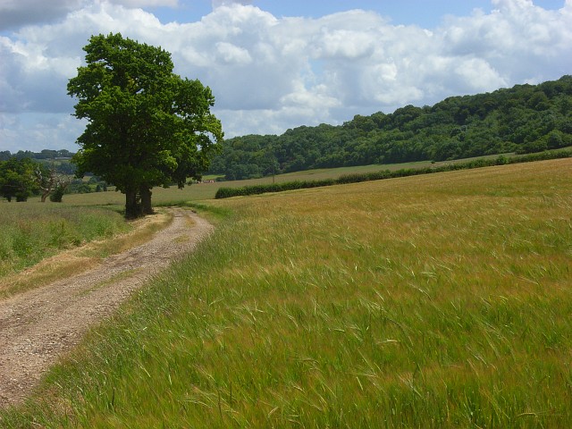
Collier's Lane. Barley to the south of the public bridleway. Pophley's Wood forms the backdrop on the southern side of the dry valley.
Chinnor, Flooded chalk quarry and SSSI. This is Quarry 3 of the former Chinnor Cement Works, viewed from Oakley Hill. It is also the Chinnor Chalk Pit SSSI, so defined by virtue of the exposure of various layers of chalk stratigraphy. The works closed in 1999 and has been completely demolished, including its landmark chimney. All that remains are a few piles of crushed concrete and the listed 1908 beehive kiln, all visible here far left.


