Tanworth-in-Arden Walks
![]()
![]() This pretty Warwickshire based village is located near Earlswood and Redditch.
This pretty Warwickshire based village is located near Earlswood and Redditch.
It's a nice place for a stroll with a picturesque village green, a 14th century church and a 300 year old pub to visit.
This circular walk from the village takes you east to Umberslade Hall. The hall dates back to 1695 and includes a large estate with some pleasant public footpaths taking you around Umberslade Park Farm. The family friendly farm includes goats, rabbits, ponies and donkeys. There's also a nice cafe where you can stop for refreshments.
To continue your walking in the area head a couple of miles north to Earlswood Lakes. There's some pleasant waterside footpaths and peaceful woodland trails in the adjacent Clowes Wood here. The long distance Midland Link passes through the village - you could follow this north to the lakes.
Postcode
B94 5AL - Please note: Postcode may be approximate for some rural locationsTanworth-in-Arden Ordnance Survey Map  - view and print off detailed OS map
Tanworth-in-Arden Open Street Map  - view and print off detailed map
Tanworth-in-Arden OS Map  - Mobile GPS OS Map with Location tracking
Tanworth-in-Arden Open Street Map  - Mobile GPS Map with Location tracking
Walks near Tanworth-in-Arden
- Earlswood Lakes - Enjoy a stroll along these three reservoirs and into the adjacent woodland on this lovely walk in Solihull
- Redditch - This lovely figure of eight walk takes you along the Miller's Trail to Arrow Valley Country Park in the Worcestershire town of Redditch
- Packwood House - This tudor house in Lapworth has nice footpaths to follow through the grounds and surrounding countryside
- Solihull Way - Starting at Earlswood Lakes head through Solihull to Castle Bromwich Hall
- Stratford Upon Avon Canal - Enjoy waterside cycling and walking on this 26 mile canal which runs from Stratford Upon Avon to Birmingham
- Clowes Wood - Enjoy miles of cycling and walking trails in this area of woodland near Whitstable
- Reigate and Banstead Millennium Trail - This splendid walk was devised by Reigate and Banstead Borough Council to celebrate the new millennium
- Olton Reservoir - Olton Reservoir or Mere is located in the Solihull area.
- Sheldon Country Park - A short walk or cycle through the pretty Sheldon Country Park in Birmingham
- Arden Way - This circular walk takes you on a tour of the beautiful Forest of Arden in Warwickshire
- Arrow Valley Country Park - Enjoy waterside cycling and walking in this splendid country park in Redditch
- Coughton Court - Explore the beautiful gardens of the Tudor Coughton Court, before a lovely waterside stroll along the River Arden on this walking route in Warwickshire
- Worcester and Birmingham Canal - Follow the Worcester and Birmingham Canal from the vibrant centre of Birmingham, through the green hills of Worcestershire, to the cathedral city of Worcester
- Tardebigge Locks - Visit the largest flight of locks in Britain on this circular walk around Tardebigge Locks on the Worcester and Birmingham Canal
- Monarch's Way - This incredible 615-mile walk approximates the escape route taken by King Charles II in 1651 after being defeated in the Battle of Worcester
- Inkberrow - This pretty Worcestershire village includes a picturesque village green, a historic church and a fine local pub
- Bittell Reservoirs - This walk visits the Upper and Lower Bittell Reservoirs in Barnt Green, near Birmingham
- Alvechurch - This Worcestershire based village has some nice canalside and riverside trails to try
- Henley in Arden Circular Walk - This circular walk explores the villages, rivers, canals and countryside surrounding the charming town of Henley in Arden in Warwickshire
Pubs/Cafes
Head to the Bell Inn for some post walk refreshment. The pub dates back over 300 years and is located in a nice spot on the Green. You can find them at postcode B94 5AL for your sat navs.
Further Information and Other Local Ideas
Just to the south east you can pick up the Henley in Arden Circular Walk. The neighbouring village is well worth exploring with a series of medieval timber framed buildings on the wonderful 1 mile high street. The route also includes easy waterside walks along the Stratford Upon Avon Canal.
Photos
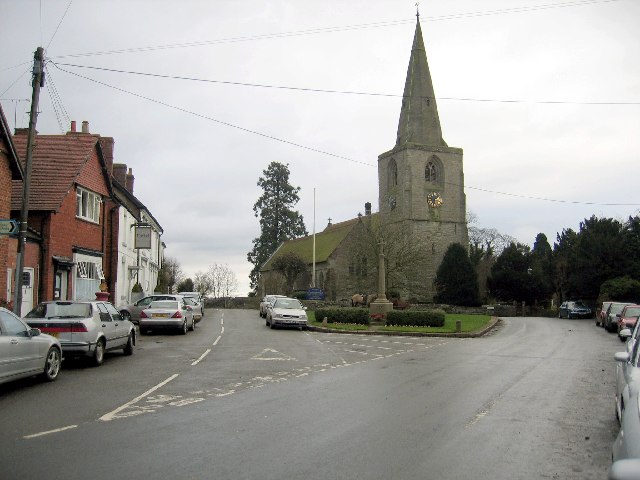
Tanworth-in-Arden. The centre of the village with the War Memorial, village green and the 14th century church of St Mary Magdalene beyond. One of this picturesque village's more dubious claims to fame was as the outdoor setting for village of King's Oak in the long defunct TV soap Crossroads. This village deserves a return visit on a sunnier day!
Umberslade Hall. Large country house which has been converted to residential apartments. Pevsner states the house was 'built for Andrew Archer, the architect Thomas Archer's brother, C 1695-1700'.
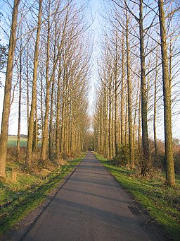
Umberslade Hall driveway. The driveway runs in a straight line from Tanworth-in-Arden for about 1.5 miles to the front of Umberslade Hall. It is seen here as it cuts across NE corner of this square. At this point the driveway is tarmaced and maintained to provide access to Umberslade Children's Farm. Follow driveway towards Tanworth-in-Arden or towards Umberslade Hall.


