Walk around Welshpool
![]()
![]() This town in Powys is located close to the Welsh-English border on the Montgomery Canal.
This walk takes you along a section of the canal from Welshpool to Berriew for a distance of about 5 miles using a flat path. As such the walk is suitable for most abilities. In Berriew you can enjoy some refreshments at the local pub before returning. On the way you'll pass Powis Castle, located just to the west of the canal. At Belan locks you could take a small detour, following a public footpath north west to the site. Here you'll find stunning gardens regarded as one of the greatest surviving examples of Baroque garden design in Britain. There's also some pockets of woodland to explore on the Belan side of the canal.
This town in Powys is located close to the Welsh-English border on the Montgomery Canal.
This walk takes you along a section of the canal from Welshpool to Berriew for a distance of about 5 miles using a flat path. As such the walk is suitable for most abilities. In Berriew you can enjoy some refreshments at the local pub before returning. On the way you'll pass Powis Castle, located just to the west of the canal. At Belan locks you could take a small detour, following a public footpath north west to the site. Here you'll find stunning gardens regarded as one of the greatest surviving examples of Baroque garden design in Britain. There's also some pockets of woodland to explore on the Belan side of the canal.
At Berriew you'll pass the Berriew aqueduct which carries the Montgomery Canal over the River Rhiw. You can cross the river on the Berriew Bridge and explore the village before returning along the towpath.
Welshpool Ordnance Survey Map  - view and print off detailed OS map
Welshpool Open Street Map  - view and print off detailed map
Welshpool OS Map  - Mobile GPS OS Map with Location tracking
Welshpool Open Street Map  - Mobile GPS Map with Location tracking
Walks near Welshpool
- Montgomery Canal - Enjoy easy waterside cycling and walking along the Montgomery Canal through Powys and Shropshire
- Powis Castle - Explore the world-class gardens surrounding this historic castle in Welshpool.
- Glyndwr's Way - Starting at Knighton on the English/Welsh border follow this wonderful 135 mile long trail through some of the most stunning landscape in Wales
- Offa's Dyke Path - This incredible 177 mile trail starts on the River Severn Estuary in Gloucestershire in England before taking you over the border into Wales and on through some truly splendid mountainous scenery
- Rodney's Pillar - This walk climbs to Admiral Rodney's Pillar on Breidden Hill in Powys, near Welshpool.
- Shropshire Union Canal - Travel from the ourskirts of Wolverhampton to Ellesmere Port on this long distance waterside walk along the Shropshire Union Canal.
The route starts at Autherley Junction in the Oxley area of Wolverhampton - Llanfair Caereinion - Llanfair Caereinion is a small riverside town located in Montgomeryshire, Powys
Further Information and Other Local Ideas
A couple of long distance walking trails pass the town. You can follow the Glyndwr's Way north west from the town or head east to pick up the Offa's Dyke Path. Both of these epic trails are waymarked and provide an opportunity for exploring the surrounding countryside on good footpaths.
One of the major attractions in the town is the Welshpool & Llanfair Light Railway. You can catch the heritage steam railway to the neighbouring settlements of Castle Caereinion and Llanfair Caereinion where you can enjoy views of the River Banwy.
A few miles to the north east you'll find the village of Middletown where you can enjoy a climb to Rodney's Pillar on Breidden Hill. The monument was built in 1781–82 to commemorate the naval victories of Sir George Brydges Rodney, Admiral of the White during the American War of Independence. There are some nice woodland trails, an Iron Age Hillfort and fine views from the summit to enjoy here.
Photos
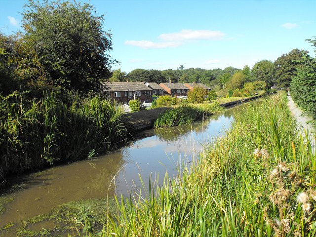
Montgomery Canal, Berriew. Looking north along the backs of houses in Maes Beuno. The residents seem to mown and planted their bank of the Canal.
Berriew Aqueduct - Montgomery Canal. The aqueduct carries the Montgomery Canal over the River Rhiw. There were problems during construction of the original design by John Dadford and his brother Thomas Dadford, Junior. William Jessop was brought in to advise the company and their father Thomas Dadford, Senior was later appointed as the engineer to complete the works.
The Wharf, Berriew. Workshops of William O'Brien, artist blacksmith. This smithy stands beside the canal and was formerly known as Lloyd's Coal Wharf. It straddles the northern gridline of the square which passes diagonally through the buildings from the far left corner of the left-most shed to the near right corner of the right-hand one. It is also accessible from the B4390 which passes immediately behind the buildings.


