Nutbrook Trail
![]()
![]() This easy cycling and walking trail runs from Long Eaton to Heanor along the Erewash Canal and a dismantled railway line. It runs for about 10 miles and is part of National Cycle Route 67. It's a great one for families or anyone looking for a safe, flat ride or walk.
This easy cycling and walking trail runs from Long Eaton to Heanor along the Erewash Canal and a dismantled railway line. It runs for about 10 miles and is part of National Cycle Route 67. It's a great one for families or anyone looking for a safe, flat ride or walk.
The route starts in Long Eaton next to West Park and follows the Erewash Canal north through Sandiacre and Stapleford. It's a pleasant section along the canal towpath with pretty locks and old stone bridges.
Just after Stapleford you leave the canal and bear west toward Ilkeston along a dismantled railway line. You'll pass through the pretty Manor Floods Nature Reserve where there is a nice lake and lots of wildlife to look out for. The final section takes you through the lovely Shipley Country Park to the finish point at Heanor. It's a great park with 700 acres of woodland, lakes and parkland.
To extend your outing you could pick up the circular Erewash Valley Trail and further explore the Derbyshire and Nottinghamshire countryside on your bike or on foot.
Nutbrook Trail Ordnance Survey Map  - view and print off detailed OS map
Nutbrook Trail Open Street Map  - view and print off detailed map
Nutbrook Trail OS Map  - Mobile GPS OS Map with Location tracking
Nutbrook Trail Open Street Map  - Mobile GPS Map with Location tracking
Pubs/Cafes
The Nutbrook Coffee Shop is located right on the trail, minutes from Shipley Park. It's about a 30 minute walk from the Shipley Country Park Visitor Centre (1.7 miles), following the Nutbrook Trail past Osbournes Pond. There's a great selection of freshly made sandwiches, panini’s, pies, pasties and a fantastic range of cakes. There's a very pretty garden area to sit out in and it's also dog friendly. You can find it on the trail at postcode DE7 6BQ for your sat navs.
Cycle Routes and Walking Routes Nearby
Photos
Two bridges. In the foreground the trail goes over its namesake, the Nut Brook. QuarryHill Road is carried over the trail on the bridge beyond.
Marlpool. The former Heanor branch of the Great Northern Railway is now used as a footpath and cycleway. Passenger services were withdrawn as early as 1928 - incidentally, making Heanor one of the first towns in the country to be deprived of a train service, the LMS station having been closed two years earlier. Frequent tram and bus services in the area at that time no doubt led to the railway's demise. Freight services continued until 1963, however.
Woodland section in Marlpool. This footpath and cycleway uses the trackbed of the Great Northern Railway's Heanor branch which lost its passenger service as long ago as 1928, although freight trains ran until 1963. A group of dog walkers heads off towards Heanor.
Cyclist on the trail at Stanton. This section, at Stanton, traverses the edge of the old Stanton Ironworks site following the line of the Stanton branch railway, and is open to horse riders as well as cyclists and walkers. It takes its name from the Nut Brook, (behind the trees on the right), and the disused Nutbrook Canal.
Old railway bridge over the trail. The trail follows the route of the dismantled Stanton railway branch line. The track that this bridge carried over the branch line used to link one side of the old Stanton Ironworks to the other. The namesake of the trail, the Nut Brook, is culverted under the footpath at this point.
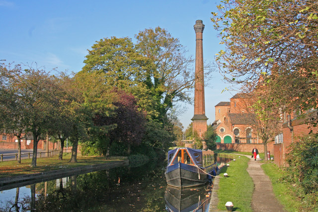
Erewash Canal looking north from Sandiacre bridge. The canal was built in 1777-1779 to carry coal from mines on either side of the Erewash valley to Leicestershire. Padmore Moorings are on the left adjacent to Town Street. Springfield Mill with its noticeable chimney was built in 1888 as a lace factory. The towpath is part of an off-road cycle route named the Nutbrook Trail.


