Barton Upon Humber Walks
![]()
![]() This Lincolnshire based market town sits in a nice location for waterside walks on the banks of the Humber Estuary.
This Lincolnshire based market town sits in a nice location for waterside walks on the banks of the Humber Estuary.
It's also the start point of the epic Viking Way which begins in the town on the southern side of the Humber Bridge. The town itself is also worth exploring with several Georgian buildings and the popular Ropewalk - an interesting arts centre housed in the former rope factory.
This walk takes you along the Humber foreshore walk from Barton Waterside to New Holland. There's great views over the water to Hull, several pretty lakes with sailboats and lots of wildlife to see along the way.
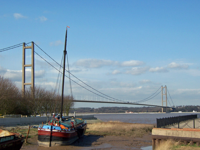
The walk starts at the car park and viewpoint at Barton Waterside where there are fine views to the iconic Humber Bridge. From here you head east, crossing the footbridge over Barton Haven and continuing to the Water's Edge visitor centre and cafe. The centre is one of the highlights of the area with a country park, nature reserve and good range of facilities.
The route continues east passing a series of sailing lakes before coming to Barrow Haven and New Holland. Here you have the option of catching the train back or returning on the same footpaths.
Postcode
DN18 5BD - Please note: Postcode may be approximate for some rural locationsBarton Upon Humber Ordnance Survey Map  - view and print off detailed OS map
Barton Upon Humber Open Street Map  - view and print off detailed map
Barton Upon Humber OS Map  - Mobile GPS OS Map with Location tracking
Barton Upon Humber Open Street Map  - Mobile GPS Map with Location tracking
Walks near Barton Upon Humber
- Humber Bridge - Follow the footpath across the Humber Bridge and enjoy fine views over the River Humber and the city of Hull in East Riding of Yorkshire
- Humber Bridge Country Park - This Country Park and Local Nature Reserve consists of woods, meadows, ponds and cliffs
- Hull - This Yorkshire port city has some fine riverside trails and pictureque local parks to explore on foot.
- Hessle Foreshore Walk - This walk takes you along a section of the Trans Pennine Trail from Hessle to Hull in East Riding of Yorkshire
- River Hull - Enjoy a walk along the Beverley Beck and the River Hull on this pleasant waterside walk in Beverley
- Brigg - This North Lincolnshire based market town has some fine waterside walking through the Ancholme Valley.
- Viking Way - Follow in the footsteps of the Norse invaders on this long distance walk from the Humber Bridge to Oakham in Rutland
- Skidby Mill - This circular walk visits Skidby Windmill near Beverley, in the East Riding of Yorkshire
- Brigg - This North Lincolnshire based market town has some fine waterside walking through the Ancholme Valley.
- Welton Dale - A circular walk around Welton Dale in East Riding of Yorkshire
- Normanby Hall Country Park - Explore the three hundred acres of parkland and woodland surrounding the 19th century Normanby Hall
- Beverley Twenty - This 20 mile walk runs from Hessle to Beverley through the Yorkshire wolds.
The walk starts near Hull in Hessle, at Humber Bridge Country Park and takes you to the Humber Estuary with fine views of the Humber Bridge - Blacktoft Sands - Enjoy a circular walk around this pretty RSPB nature reserve
- Londesborough Park - Enjoy a lovely stroll through the Londesborough Estate on this short walk near Pocklington, in the East Riding of Yorkshire
- Spurn Point - This walk explores the splendid Spurn Point National Nature Reserve on the tip of the coast of the East Riding of Yorkshire
- Hornsea Mere - Enjoy a walk along this lovely freshwater lake in the seaside town of Hornsea
- Burton Constable - Explore the extensive parks and gardens of this Elizabethan country house near Hull
Pubs/Cafes
On the route you could stop off at the Water's Edge visitor centre for some refreshment. The site includes the Honey Pot cafe where there's a good selection of drinks and meals. You can sit outside on the decking area and enjoy fine views over the estuary. It's also a country park with 110 acres of nature reserve with ponds and lots of wildlife to see. You can find the centre at postcode DN18 5JR.
There's also The Viking Way Cafe Bar at the start of the route. The cafe is housed in a historic lifeboat station on the Humber Estuary next to the bridge. They serve a good range of meals and snacks and can be found at postcode DN18 5BD. The cafe marks the start of the long distance footpath which follows in the footsteps of the Norse invaders.
Further Information and Other Local Ideas
Head west along the Viking Way and you could visit the Far Ings Nature Reserve. The reserve is run by the Lincolnshire Wildlife Trust and one of the best places in the country to see the bittern.
For more walking ideas in the area see the Lincolnshire Walks page.
Photos
Humber Foreshore. Foreshore path near the Waters' Edge Visitor Centre offers the chance of a bracing walk on a cold and windy December afternoon.


