Normanby Hall Country Park
![]()
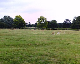
![]() Explore the three hundred acres of parkland and woodland surrounding the 19th century Normanby Hall. You can visit the deer park where you can see herds of red and fallow deer then on to the ice house, Victorian laundry, coach house, stables and the splendid Victorian Walled Garden. There is also a lovely woodland section with mature beeches, oaks and sweet chestnuts.
Explore the three hundred acres of parkland and woodland surrounding the 19th century Normanby Hall. You can visit the deer park where you can see herds of red and fallow deer then on to the ice house, Victorian laundry, coach house, stables and the splendid Victorian Walled Garden. There is also a lovely woodland section with mature beeches, oaks and sweet chestnuts.
The park is located a few miles north of Scunthorpe near the village of Burton-upon-Stather.
Cyclists can reach the park on National Cycle Route 169 which runs north from Manor Park in Scunthorpe.
Please click here for more information
Normanby Hall Country Park Ordnance Survey Map  - view and print off detailed OS map
Normanby Hall Country Park Open Street Map  - view and print off detailed map
Normanby Hall Country Park OS Map  - Mobile GPS OS Map with Location tracking
Normanby Hall Country Park Open Street Map  - Mobile GPS Map with Location tracking
Further Information and Other Local Ideas
Our Scunthorpe Walk takes you through the popular Central Park to Brumby Woods nature reserve in the town centre.
A few miles south west you can visit Crowle and enjoy a waterside stroll along the Keadby Canal. Here you can also pick up the Peatlands Way to explore Thorne Moors and Hatfield Moors, part of the Humberhead Peatlands National Nature Reserve. The moors are the second largest lowland raised peat bog in England and notable for their diversity of wildlife and plantlife.
A few miles to the south east you can visit the interesting market town of Brigg and enjoy a waterside walk along the New River Ancholme to the Humber Bridge on the Humber Estuary near Hull and Barton Upon Humber.
Just to the north you can pick up the Burton Upon Stather and Alkborough Flats Walk. This will take you to the noteworthy Trent Falls - the point where the Rivers Ouse, Humber and Trent all meet. Much of the area is also a nature reserve with a wide variety of birds to look out for.
For more walking ideas in the area see the Lincolnshire Walks page.
Cycle Routes and Walking Routes Nearby
Photos
The Normanby estate was purchased by Edmund Sheffield from Nicholas Girlington in 1591 and a five floor mansion with three turrets was built here by architect Robert Smythson during the 1590s. The house survived for just over 100 years although nothing of Smythson's Hall now remains above ground. It was apparently replaced by a more ordinary looking house until 1820 when Sir Robert Sheffield sold up the family's remaining properties in London and had the present house designed and built by Robert Smirke, the architect of the British Museum.
Normanby Hall Gardens. One of many graves in the Sheffield family's pet cemetery in the grounds at Normanby Hall. This headstone marks the final resting place of "Lady Sheffield's pet mare for 16 years - died Feb 11th 1880".


