Birchover Walks
![]()
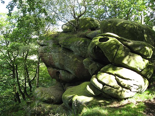
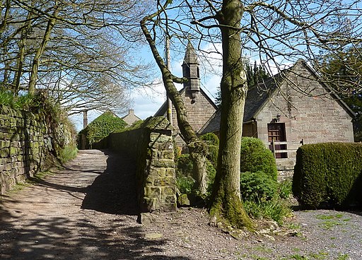
![]() This Peak District village is a fine place to start a walk. The village is surrounded by some splendid moorland scenery with many sites of geological interest to explore. It's a picturesque place with a number of fine old cottages built with the pink gritstone from the nearby Stanton Moor quarries.
This Peak District village is a fine place to start a walk. The village is surrounded by some splendid moorland scenery with many sites of geological interest to explore. It's a picturesque place with a number of fine old cottages built with the pink gritstone from the nearby Stanton Moor quarries.
This circular walk from the village visits the Nine Ladies Stone Circle, Stanton Moor and Darley Dale.
The walk starts in the village and heads north east to climb to Stanton Moor and the Nine Ladies. These 9 upright stones are thought to depict nine ladies turned to stone as a penalty for dancing on Sunday. The site dates from the Bronze age about 3,000 to 4,000 years ago.
The route then heads south east to Stanton Lees, Bee Hill and Warencarr before heading to Darley Bridge on the River Derwent. In this area you could pick up the Derwent Valley Heritage Way and enjoy a stroll along the river towards Rowsley.
The route then heads west along Oldfield Lane, passing Cowley Knowl, Sabine Hay Wood and Birchover Wood before returning to the village.
To extend the walk head west to visit the popular Robin Hood's Stride. The splendid rock formation is one of the highlights of the area. There's also the Bronze Age Nine Stones Close Stone Circle just north of the rocks.
Postcode
DE4 2BL - Please note: Postcode may be approximate for some rural locationsBirchover Ordnance Survey Map  - view and print off detailed OS map
Birchover Open Street Map  - view and print off detailed map
Birchover OS Map  - Mobile GPS OS Map with Location tracking
Birchover Open Street Map  - Mobile GPS Map with Location tracking
Walks near Birchover
- Nine Ladies Stone Circle Walk - This walk visits the fascinating Bronze Age stone circle of the Nine Ladies in the Derbyshire Peak District.
- Stanton Moor - This upland area near the Derbyshire village of Stanon-in-Peak has good walking trails, attractive woodland and fascinating ancient historical sites to visit.
You can start the walk at the village of Stanon-in-Peak near Matlock - Darley Dale - Enjoy a walk through the pretty Darley Dales on this waterside route in the lovely Derbyshire Dales
- Winster - This attractive Peak District village is surrounded by some lovely limestone hills, woods and countryside.
- Matlock - The county town of Matlock is a great base for exploring the south eastern edge of the Peak District
- Limestone Way - Travel through the beautiful Peak District National Park on this walk through Derbyshire and into Staffordshire.
The walk starts at Castleton, passing through the scenic Cave Dale and past the remains of Peverill Castle - Youlgreave - A circular walk around the village of Youlgreave in the Derbyshire Peak District
- Rowsley - This village is located in a lovely spot in the Derbyshire Dales area of the Peak District
- Heights of Abraham - Ride a cable car to the Hilltop Park and enjoy magnificent views of the Derwent Valley and surrounding Peak District at this major attraction in Matlock
- Bakewell - The market town of Bakewell makes and excellent base for exploring the Derbyshire Dales area of the Peak District National Park.
This long circular walk visits some of the villages, parks, woods and hills surrounding the town - Chatsworth Park - This circular walk takes you around the splendid Chatsworth Park in the Derbyshire Peak District
- Brassington - This attractive Derbyshire Dales village is close to a number of popular waymarked trails and a major local reservoir
- Middleton Top - At Middleton Top you will find an excellent visitor centre with a number of good walking trails to try
- Carsington Water - This route follows the circular cycling and walking trail around Carsington Water in Ashbourne, Derbyshire
- Robin Hood's Stride - This walk visits Robin Hood's Stride, a wonderful rock formation near Bakewell in Derbyshire.
Pubs/Cafes
There's a couple of fine pubs in the village for post walk refreshment. The Red Lion dates back to 1680 and includes oak beams, stone walls, log burners and a nice patio area. Just up the street there's also The Druid Inn to try. It too has an interesting history having once been the meeting place of the Druids who used the sites around the village for ceremonial worship in ancient times.
Dog Walking
The moorland and woodland on the route make for a fine dog walk. The village pubs mentioned above are also dog friendly.
Further Information and Other Local Ideas
Head a few miles south and you could pick up the circular Brassington Walk and visit Middleton Top and the expansive Carsington Water.
For more walking ideas in the area see the Derbyshire Walks and the Peak District Walks pages.


