Brassington Walks
![]()
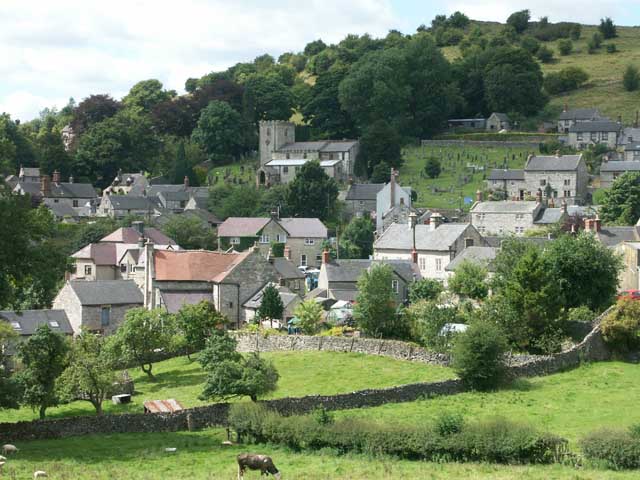
![]() This attractive Derbyshire Dales village is close to a number of popular waymarked trails and a major local reservoir. The historic settlement includes several centuries old limestone cottages, a church dating from the Norman period and a notable Tudor house built in 1615. The Peak District is also not far away.
This attractive Derbyshire Dales village is close to a number of popular waymarked trails and a major local reservoir. The historic settlement includes several centuries old limestone cottages, a church dating from the Norman period and a notable Tudor house built in 1615. The Peak District is also not far away.
This circular walk from the village takes you to some of the local walking highlights including the splendid viewpoint at Middleton Top and the expansive Carsington Water.
The walk starts in the village and heads north to Longcliffe Dale Farm where you can pick up the Limestone Way and follow the waymarked footpath to a junction where 4 trails cross. At this point you can pick up the Midshires Way, High Peak Trail and the Pennine Bridleway and follow the trails east past Harboro Rocks to Middleton Top near Wirksworth.
The route then heads south west, following a footpath to Hopton and Carsington village. Continue south and you'll soon pick up a lakeside trail which will take you to the visitor centre at the site.
The route then leaves the lake, heading west to Knockerdown before following Brackendale Lane to Bradbourne. Here you turn north to follow another country lane back to Brassington.
Postcode
DE4 4HJ - Please note: Postcode may be approximate for some rural locationsBrassington Ordnance Survey Map  - view and print off detailed OS map
Brassington Open Street Map  - view and print off detailed map
Brassington OS Map  - Mobile GPS OS Map with Location tracking
Brassington Open Street Map  - Mobile GPS Map with Location tracking
Walks near Brassington
- Middleton Top - At Middleton Top you will find an excellent visitor centre with a number of good walking trails to try
- Carsington Water - This route follows the circular cycling and walking trail around Carsington Water in Ashbourne, Derbyshire
- Wirksworth - This circular walk around the Derbyshire town of Wirksworth uses various footpaths to visit some of the highlights of the area.
Starting in the town you head north and pick up the High Peak Trail to take you up to the Black Rocks around Cromford - Limestone Way - Travel through the beautiful Peak District National Park on this walk through Derbyshire and into Staffordshire.
The walk starts at Castleton, passing through the scenic Cave Dale and past the remains of Peverill Castle - Midshires Way - This route follows public bridleways and quiet country lanes through Middle England, from Bledlow, near Aylesbury in Buckinghamshire, to Stockport in Greater Manchester
- High Peak Trail - This splendid, shared walking and cycle trail follows a disused railway line from Cromford to Dowlow through the beautiful Peak District.
The trail starts near Cromford railway station and climbs through the stunning High Peak area of Derbyshire giving fabulous views of the area.
The trail links with the popular Tissington Trail at High Peak Junction - Pennine Bridleway - This fabulous 120 mile long trail runs through the beautiful Derbyshire Peak District, through Lancashire and on into Yorkshire.
It is suitable for mountain bikers, horse riders and walkers taking you on a tour through some of the most beautiful parts of the country - Ashbourne - The Derbyshire Dales town of Ashbourne is a fantastic base for walkers looking to explore the southern end of the Peak District
- Black Rocks Cromford - This circular walk visits Black Rocks in the Peak District National Park
- Around Belper - This long circular walk makes use of two of the waymarked long distance trails running through the countryside surrounding the Derbyshire town of Belper
- Cromford Mill - This circular walk visits the village of Cromford and its historic mills
- Winster - This attractive Peak District village is surrounded by some lovely limestone hills, woods and countryside.
- Birchover - This Peak District village is a fine place to start a walk
- Darley Dale - Enjoy a walk through the pretty Darley Dales on this waterside route in the lovely Derbyshire Dales
- Tissington Trail - The Tissington trail is a 13 mile off road path following the trackbed of a disused railway line through the stunning Peak District National Park.
The trail is shared by walkers and cyclists offering fabulous views of the Derbyshire countryside - Matlock - The county town of Matlock is a great base for exploring the south eastern edge of the Peak District
- Robin Hood's Stride - This walk visits Robin Hood's Stride, a wonderful rock formation near Bakewell in Derbyshire.
- Minninglow - This walk climbs to Minninglow Hill in the White Peak area of the Peak District National Park.
Pubs/Cafes
Back in the village you can enjoy some well earned refreshment at the Olde Gate Inn. The historic inn dates back to the 17th century and is Grade II listed. Bonnie Prince Charlie’s soldiers were billeted at the inn on their march to London, and some of the oak beams came from ships of the Spanish Armada. It's been named Britain’s cosiest pub by The Times with its charming interior and roaring fires. Outside there's a lovely large garden area with fine views. They serve high quality gastro food and have a good selection of ales. You can find them on Well Street with a postcode of DE4 4HJ for your sat navs.
Dog Walking
The country trails are great for fit dogs and the Olde Gate mentioned above is also dog friendly.
Further Information and Other Local Ideas
Head a few miles to the west and you can pick up the popular Tissington Trail, a shared cycling and walking route running along a disused railway line. The splendid gardens at Tissington Hall can also be found here.
You can follow the High Peak Trail on to Minninglow where you will find a fine hill climb and some significant ancient tombs.
For more walking ideas in the area see the Derbyshire Walks and the Peak District Walks pages.
Photos
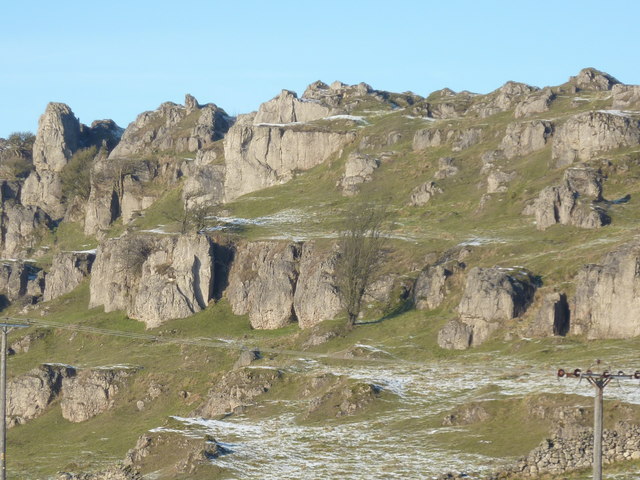
Harboro' Rocks, above the village. An outcrop of Dolomitic Limestone on the high ridge above Brassington, Harboro Rocks are notable for their spiky outline. They offer good quality, if short, rock climbs. The rocks are just off the High Peak Trail and there are no access problems. Daniel Defoe came here on his 'Tour through Great Britain' in the early 18th century and described a family living in Harboro Cave - a natural cavern in the edge which has been excavated by archaeologists who have found evidence of occupation from the Ice Age onwards.


