Burton on Trent to Barton under Needwood Canal Walk
![]()
![]() This walk follows a lovely section of the Trent and Mersey Canal from Burton Upon Trent to Barton Marina in the the nearby village of Barton under Needwood. On the way you'll pass Branston Water Park where there's a series of lakes and lots of wildlife to look out for.
This walk follows a lovely section of the Trent and Mersey Canal from Burton Upon Trent to Barton Marina in the the nearby village of Barton under Needwood. On the way you'll pass Branston Water Park where there's a series of lakes and lots of wildlife to look out for.
There's also pretty locks and nice open views over the surrounding Staffordshire countryside.
You start in Shobnall and follow the canal south through Branston before finishing at Barton Turns Marina.
The route follows a section of the long distance Way for the Millennium. You can extend the walk by continuing along the canal to Alrewas where you follow the River Swarbourn through Wychnor Park.
Burton on Trent to Barton under Needwood Canal Walk Ordnance Survey Map  - view and print off detailed OS map
Burton on Trent to Barton under Needwood Canal Walk Open Street Map  - view and print off detailed map
Burton on Trent to Barton under Needwood Canal Walk OS Map  - Mobile GPS OS Map with Location tracking
Burton on Trent to Barton under Needwood Canal Walk Open Street Map  - Mobile GPS Map with Location tracking
Further Information and Other Local Ideas
If you continue south along the canal you will soon come to the National Memorial Arboretum. There are 30,000 trees in the 150 acre Arboretum, forming a unique living tribute to those who have served and continue to serve our country.
Head east along the canal and you could visit the neighbouring village of Willington. Here you can pick up the circular Willington Walk which visits the Gravel Pits Nature Reserve. There's also a 12th century church and the Mercia Marina to visit. The site is notable as the largest inland marina in the UK and one of the largest in Europe.
The Yoxall and Needwood Forest Walk passes through Barton. It explores the ancient Needwood Forest area of the National Forest, using the National Forest Way long distance trail. On the way it visits Alrewas and Fradley Junction, Branston Water Park and the Football Association's St George's Park National Football Centre.
Just to the east of Barton there's the Rosliston Forestry Centre to explore. The centre provides a wealth of information on the area and also has on site bike hire. The surrounding parkland is well worth exploring too with woodland trails, meadows, ponds, lots of butterflies and some interesting sculptures to see. The Woodland Trust's Badger Wood can also be accessed in this area.
For more walking ideas in the area see the Staffordshire Walks page.
Cycle Routes and Walking Routes Nearby
Photos
Trent and Mersey Canal at Shobnall, Staffordshire. Close by is the justly celebrated Marston's Burton Brewery. If you can arrange to have a tour of it, you won't be disappointed.
Branston Lock, Trent and Mersey Canal, Staffordshire. This is a fairly shallow lock which drops the water level by three feet (91.5cm). The canal was engineered by James Brindley and took eleven years to build. it opened in 1777, 93 miles in length from Derwent Mouth to Preston Brook. There are 76 locks, this being No 8.
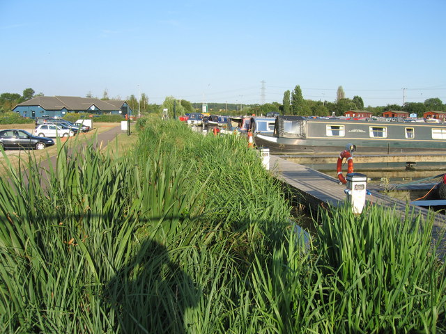
Barton Turns Marina, Barton-under-Needwood. The marina was excavated at the side of the Trent and Mersey Canal and is one large basin, divided up by wooden pontoons. It opened a few years ago and has become very popular with canal boat enthusiasts. It offers residential moorings, temporary moorings for visitors and narrow boat hire; in addition to boat sales and a full-range of services for boaters. The blue building on the left of the image is a shop, chandlery and administration block.


