Chelmorton Walks
![]()
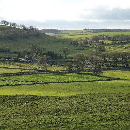
![]() This circular walk explores the area around the Peak District village of Chelmorton near Buxton in the White Peak. The interesting village includes typical limestone walls, an 18th century pub, an 11th century church and the Illy Will Water stream running through the settlement.
This circular walk explores the area around the Peak District village of Chelmorton near Buxton in the White Peak. The interesting village includes typical limestone walls, an 18th century pub, an 11th century church and the Illy Will Water stream running through the settlement.
The route uses several of the local long distance trails to visit Deep Dale, Wye Dales and Chee Dale in the Derbyshire Dales. There's some wonderful limestone scenery, deep gorges, riverside trails and fine views of the surrounding Peak District scenery from the high points.
The walk starts in the village and picks up the Midshires Way which you can follow north west to Deep Dale.
Head north through the dale and it will lead you to Wye Dale where you can follow paths along the River Wye. Here you can pick up the Monsal Trail and head east to Chee Dale. Near Miller's Dale the route turns south along the Limestone Way, passing Sough Top and Taddington Moor before returning to Chelmorton.
Postcode
SK17 9SL - Please note: Postcode may be approximate for some rural locationsChelmorton Ordnance Survey Map  - view and print off detailed OS map
Chelmorton Open Street Map  - view and print off detailed map
Chelmorton OS Map  - Mobile GPS OS Map with Location tracking
Chelmorton Open Street Map  - Mobile GPS Map with Location tracking
Walks near Chelmorton
- Buxton - The popular spa town of Buxton has a number of waymarked trails taking you though this beautiful area of the Peak District
- Chee Dale - This steep sided gorge near Buxton is a lovely place for a peaceful walk
- Miller's Dale - This popular beauty spot on the River Wye is one of the highlights of the Peak District National Park
- Monsal Dale - This circular walk explores the beautiful Monsal Dale in the Derbyshire Dales
- Monsal Head - This circular walk from Monsal Head crosses the Headstone Viaduct for fine views across the Derbyshire Dales.
- Monsal Trail - Follow the Monsal Trail through the Peak District National Park on this cycling and walking path.
The trail follows a disused railway line from Chee Dale near Buxton to Bakewell with the first section following the River Wye to Monsal Head via Cressbrook Dale and Miller's Dale - Bakewell - The market town of Bakewell makes and excellent base for exploring the Derbyshire Dales area of the Peak District National Park.
This long circular walk visits some of the villages, parks, woods and hills surrounding the town - Lathkill Dale - Enjoy a splendid riverside walk in the beautiful Lathkill Dale in the Peak District
- Chatsworth Park - This circular walk takes you around the splendid Chatsworth Park in the Derbyshire Peak District
- Cressbrook Dale - This walk follows pubic footpaths through Cressbrook Dale Nature Reserve in the Derbyshire Dales.
The walk starts in the village of Cressbrook which sits at the southern end of the Dale - Limestone Way - Travel through the beautiful Peak District National Park on this walk through Derbyshire and into Staffordshire.
The walk starts at Castleton, passing through the scenic Cave Dale and past the remains of Peverill Castle - High Wheeldon - This walk climbs High Wheeldon Hill in the Upper Dove Valley area of the Peak District
- Taddington - This Derbyshire based village is in a great location for exploring some of the major Peak District highlights on foot.
Pubs/Cafes
Back in the village head to the Church Inn for some post exercise relaxation and refreshment. The fine stone pub dates back to 1742 and sits opposite the village church. There's roaring open fires in the winter, a beautiful sun trap of a beer garden and patio for summer al fresco dining. You can find them at postcode SK17 9SL for your sat navs.
Dog Walking
The country, hill and woodland trails are ideal for fit dogs. The Church Inn mentioned above is also dog friendly.
Further Information and Other Local Ideas
Just to the south you can try the circular walk from Hurdlow which climbs to the viewpoint at High Wheeldon. The little hamlet has a good sized public car park and a charming country pub to relax in afterwards. The High Peak Trail can also be picked up here. The shared cycling and walking trail runs along an old railway line from Cromford to Dowlow.
For more walking ideas in the area see the White Peak Walks page.


