East Hendred Walks
![]()
![]() This rural village in Oxfordshire is located in the North Wessex Downs AONB and the historic Vale of White Horse near the settlements of Ardington and Wantage. The interesting village includes some historic buildings including the 15th century Hendred House and a parish church dating back to the 12th century.
This rural village in Oxfordshire is located in the North Wessex Downs AONB and the historic Vale of White Horse near the settlements of Ardington and Wantage. The interesting village includes some historic buildings including the 15th century Hendred House and a parish church dating back to the 12th century.
This circular walk from the village visits neighbouring West Hendred before heading south to The Ridgeway National Trail where you can enjoy a climb to Cuckhamsley Hill.
The walk starts in the village and heads west to West Hendred, which lies less than a mile away. Here you can follow trails south to Goldbury Hill before picking up a waterside path along the Ginge Brook. This will take you to East Ginge before linking up with the Ridgeway on East Ginge Down.
The route heads east to the viewpoint at the 203 metre high Cuckhamsley Hill and then continues to East Hendred Down. Here you turn north to the Meashill Plantation and Aldfield Common before returning to the village.
East Hendred Ordnance Survey Map  - view and print off detailed OS map
East Hendred Open Street Map  - view and print off detailed map
*New* - Walks and Cycle Routes Near Me Map - Waymarked Routes and Mountain Bike Trails>>
East Hendred OS Map  - Mobile GPS OS Map with Location tracking
East Hendred Open Street Map  - Mobile GPS Map with Location tracking
Walks near East Hendred
- Ardington - This pretty village is located in the Vale of White Horse in Oxfordshire, just to the east of Wantage
- Wantage - The Oxfordshire town of Wantage is in a great location for exploring a lovely section of the Ridgeway
- Badbury Clump - This walk explores Badbury Hill and the lovely wooded area of Badbury Clump near Faringdon
- Uffington White Horse - This short circular walk visits White Horse Hill and the Iron Age hillfort of Uffington Castle near Swindon.
- Wayland's Smithy - Visit this fascinating Neolithic long barrow and chamber tomb on this circular walk on the The Ridgeway
- Chilton Downs Circular Walk - This Oxfordshire based village is in a good location for exploring the countryside of the Vale of White Horse on the nearby Ridgeway.
- Didcot - The Oxfordshire town of Didcot has some nice trails to follow into the surrounding Chilterns countryside.
This walk visits some of the highlights of the area using a mixture of country lanes, public footpaths and waymarked long distance trails - Wittenham Clumps - This circular walk climbs to these two distinctive hills near Dorchester
- Dorchester Circular Walk - The delightful Oxfordshire town of Dorchester on Thames has some lovely footpaths to follow through the surrounding countryside and woodland
- Blewbury - This walk from the Oxfordshire village of Blewbury visits the Iron Age Hillfort at Blewburton Hill
- Abingdon Circular Walk - This circular walk explores the area to the south of this pretty Oxfordshire town
- Faringdon Circular Walk - This circular walk around the Oxfordshire town of Faringdon, visits Faringdon Folly and the village of Littlelworth
- Sutton Courtenay - This route from the Oxfordshire village of Sutton Courtenay uses part of the Thames Path and other public footpaths to create a circular walk through the surrounding area.
- West Ilsley Downs and Scutchamer Knob Circular Walk - A circular walk through the countryside to the north of the Berkshire village of West Ilsley, visiting the Ilsley Downs and Scutchamer Knob.
Pubs/Cafes
Back in the village the Eyston Arms is a good choice for some post walk refreshment. The pub serves good quality dishes and includes a lovely terrace garden area. You can find them on the High Street at postcode OX12 8JY for your sat navs.
There's also the historic Wheatsheaf Inn which dates back to the 16th century. There's a charming interior with old interesting features and a large garden for warmer days. You can find them at postcode OX12 8JN for your sat navs.
Photos
Cottage on the bend. The village is on East Hendred Brook, which flows from the Berkshire Downs to join the River Thames at Sutton Courtenay near Culham
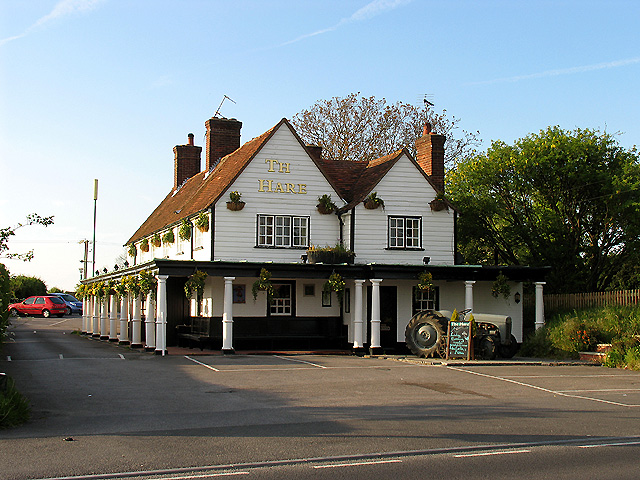
The Hare: West Hendred. This less traditionally designed pub is situated on the road from East to West Hendred, in the south eastern section of the grid square. The picture was taken from the south side of the road looking more or less north.


