Greenbooth Reservoir Circular Walk
![]()
![]() Enjoy a circular walk around Greenboth Reservoir and the Naden Reservoirs on this route in the Rochdale area of Greater Manchester. It's a lovely, peaceful area with nice views towards Manchester and the nearby Scout Moor Wind Farm, the highest point of the Rossendale Valley. With four reservoirs to walk to and great views of the surrounding moorland scenery there's plenty to see in the area.
Enjoy a circular walk around Greenboth Reservoir and the Naden Reservoirs on this route in the Rochdale area of Greater Manchester. It's a lovely, peaceful area with nice views towards Manchester and the nearby Scout Moor Wind Farm, the highest point of the Rossendale Valley. With four reservoirs to walk to and great views of the surrounding moorland scenery there's plenty to see in the area.
The Rochdale Way passes the reservoirs so you could pick this up and head west across Knowl Moor to Knowl Hill to extend your walk. You could then descend to Ashworth Moor where you can visit the lovely Owd Betts pub and try a walk around Ashworth Moor Reservoir.
If you head east you can visit Spring Mill Reservoir and the town of Whitworth. Near here is Watergrove Reservoir where you can pick up the waterside trail and enjoy views of the surrounding attractive moorland with great views across Manchester to the Cheshire plain. Just to the south there's the Ashworth Valley where there's nice trails along the Naden Brook and the Cheesden Brook.
Postcode
OL11 5TT - Please note: Postcode may be approximate for some rural locationsGreenbooth Reservoir Ordnance Survey Map  - view and print off detailed OS map
Greenbooth Reservoir Open Street Map  - view and print off detailed map
*New* - Walks and Cycle Routes Near Me Map - Waymarked Routes and Mountain Bike Trails>>
Greenbooth Reservoir OS Map  - Mobile GPS OS Map with Location tracking
Greenbooth Reservoir Open Street Map  - Mobile GPS Map with Location tracking
Pubs/Cafes
Head west of the water and visit the noteworthy Owd Betts for some post walk refreshments. This traditional country pub dates all the way back to 1796. They have a good menu and a fine outdoor area with lovely views over the surrounding moors. It's a great place to relax with a drink after your exercise. You can find the pub right next to Ashworth Moor Reservoir on Edenfield Rd with a postcode of OL12 7TY for your sat navs. The inn is also dog friendly if you are with your canine friend.


Pictured above Owd Betts and the views from the pub. This stone building was built overlooking the Cheeseden Valley in 1796 by Richard and Mary Ashworth, probably as a farmhouse. By the time that the building passed to their son, Richard, and his wife, Betty, in the mid 1800s it had become an inn named the 'Hare and Hounds.’ Following the death of her husband Betty continued to run the inn alone and it was probably during this period that it became affectionately known as ‘Owd Betts.’ In 1893 Betty too passed away at the age of 93, but the pub continued to be known as ‘Owd Betts.’ However, it was not until the 1950s that, in deference to the grand lady, the name of the pub was officially changed from the 'Hare and Hounds’ to that by which it is known today, ‘Owd Betts.’
Further Information and Other Local Ideas
Cowm Reservoir sits a few miles north east of the lake. There's another nice circular walk here with a popular watersports centre as well.
For more walking ideas in the area see the Greater Manchester Walks and South Pennines Walks pages.
Cycle Routes and Walking Routes Nearby
Photos
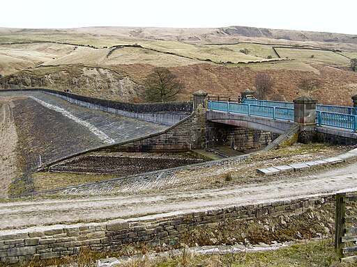
Greenbooth Reservoir. Looking North East from the west corner or the dam. The reservoir is on the site of Greenbooth village which was abandoned in the late 1950s for the construction of the reservoir. There is a plaque on the side of the reservoir dam wall which reads: "This tablet commemorates the village of Greenbooth, the site of which is submerged beneath the waters of this reservoir."
The old Lodge Dam to Greenbooth Village Works. View from Rochdale Way looking east to west across the old Lodge Dam which supplied the works in Greenbooth Village. This is now usually submerged under some 10 metres of water.


