Haverfordwest Walks
![]()
![]() Haverfordwest is the county town of Pembrokeshire. There are some nice waterside walks along the River Cleddau which runs through the town. The town is also not far from the wonderful Pembrokeshire Coast Path.
Haverfordwest is the county town of Pembrokeshire. There are some nice waterside walks along the River Cleddau which runs through the town. The town is also not far from the wonderful Pembrokeshire Coast Path.
This walk takes you along the Western Cleddau to the village of Little Milford, just to the south of the town. The walk starts at the ruins of Haverfordwest priory, located next to the river, just to the south west of the train station. It's a peaceful and atmospheric spot with the picturesque ruins and flowing river. There's also a number of information boards detailing the history of the priory which dates back to the 12th century. From here you can pick up a public footpath heading south along the river to the village of Little Milford. The area is run by the National Trust and includes ancient woodland and river views. You can follow the peaceful trails around the woods before returning to Haverfordwest on the same river paths.
If you continue south you could visit nearby Llangwm where there are some fine trails along the river estuary with lots of wildlife to look out for on the way.
Postcode
SA61 1UL - Please note: Postcode may be approximate for some rural locationsHaverfordwest Ordnance Survey Map  - view and print off detailed OS map
Haverfordwest Open Street Map  - view and print off detailed map
Haverfordwest OS Map  - Mobile GPS OS Map with Location tracking
Haverfordwest Open Street Map  - Mobile GPS Map with Location tracking
Walks near Haverfordwest
- Canaston Woods - Enjoy a walk or cycle around these pretty woodlands in Pembrokeshire
- Picton Castle Gardens - Explore the stunning gardens surrounding this 13th century stately home in Pembrokeshire
- Landsker Borderlands Trail - A super circular walk through the Pembrokeshire and Carmarthenshire countryside visting the River Cleddau estuary, the Ogham stones, the Norman castles at Llawhaden and Carew Castle as well as the prehistoric remains at Llawhaden.
- Slebech Park - This 600 acre estate is covered with miles of footpaths making it an excellent location for walkers
- Scolton Manor Country Park - Explore 60 acres of country park surrounding this Victorian manor house in Haverfordwest.
- Pembrokeshire Coast Path - Brace yourself for some spectacular coastal scenery on this magnificent 186 mile trail that passes through the Pembrokeshire Coast National Park
- Blackpool Mill - This circular walk visits the 19th century Blackpool Mill in the Pembrokeshire Coast National Park.
- Narberth - This delightful market town in Pembrokeshire includes an attractive High Street with many Edwardian and Georgian buildings to admire.
- Brunel Trail - This shared cycling and walking trail follows a disused railway line from Neyland to Johnston and Haverfordwest
- Llangwm - These pretty little Pembrokeshire village is located in a fine spot on the western side of the River Cleddau estuary near Haverfordwest.
Pubs/Cafes
The Bristol Trader is in a nice location right next to the river. The pub has an interesting history as there has been an inn at the quay since at least the 1700’s. It was once a bustling trading port at the tidal limit of the river Cleddau, upstream from Milford Haven. They do good food and can be found on Quay Street at a postcode of SA61 1BE.
Dog Walking
The riverside paths and woodland trails on the route make for a good dog walk. The Bristol Trader Pub mentioned above is also dog friendly.
Further Information and Other Local Ideas
Head east of the town and you'll soon come to the nearby Picton Castle Gardens. There's some nice easy footpaths to follow around the grounds of the historic castle. Near here you can pick up the Landsker Borderlands Trail, visit Slebech Park and explore the expansive
Canaston Woods.
To the north of the town is Scolton Manor Country Park where there's 60 acres of attractive parkland surrounding a Victorian manor house.
The Brunel Trail can be picked up in Harverfordwest. The popular route runs south along an old railway line to Johnston and Neyland Marina. It's traffic free so suitable for both cyclists and walkers.
Photos
Haverfordwest priory ruins. The priory was built by the Augustinian monastic order on the bank of the Cleddau just outside the town wall in the early C13. It consisted of a cruciform church, cloister, garden and ancillary structures. The monks would have made a living from rents and spiritual duties, while providing work for the local people who serviced the priory.
River Cleddau at Haverfordwest from the Priory ruins. The County Hall can be seen to the right and the old quayside warehouses centre left.
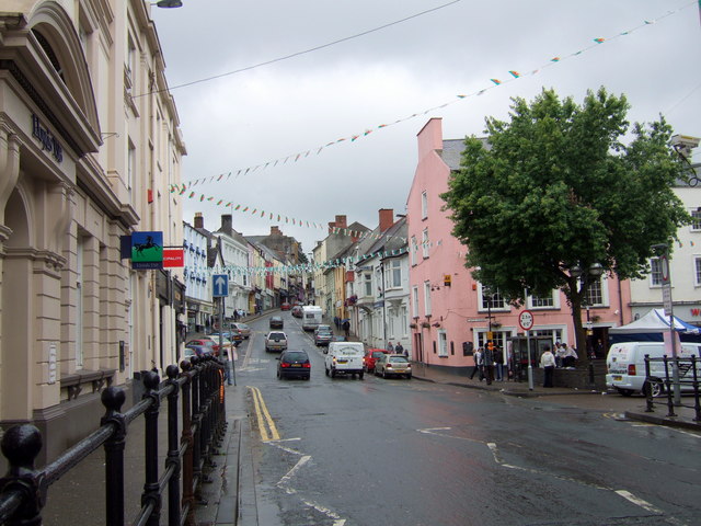
Looking up the High Street. Entering the town at this point, from Picton Place across the new bridge, there is a prospect of the High Street climbing up from Castle Square towards St Mary's Church at the top of the hill. The bridge, and the terraces lining it, were built in the early 1830's. The bank on the left in the image was the family home of Gwen and Augustus John towards the end of the C19. The pink building is the Castle Hotel.


