King's Lynn and The Walks
![]()
![]() This nice circular walk takes you around 'The Walks' urban park before a riverside stroll along the Great Ouse. The Norfolk market town is a great place for a walk with wonderful architecture, a fascinating history and lovely riverside paths.
This nice circular walk takes you around 'The Walks' urban park before a riverside stroll along the Great Ouse. The Norfolk market town is a great place for a walk with wonderful architecture, a fascinating history and lovely riverside paths.
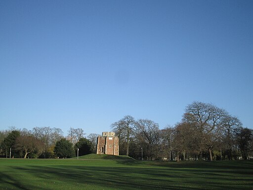
The walk starts in the park next to the train station in the centre of town. The lovely 42 acre park has nice surfaced footpaths, a 15th century chapel, beautiful landscaping, a children’s play area, toilets and a cafe. After strolling through the park the route heads through the streets to the quay on the river. You then head towards South Lynn before crossing the bridge and following the paths along the western side of the river through West Lynn. Here you can catch the ferry which runs about every 20 mins from 7am to 6pm (excluding Sundays). You can then retrace your steps back to the park.
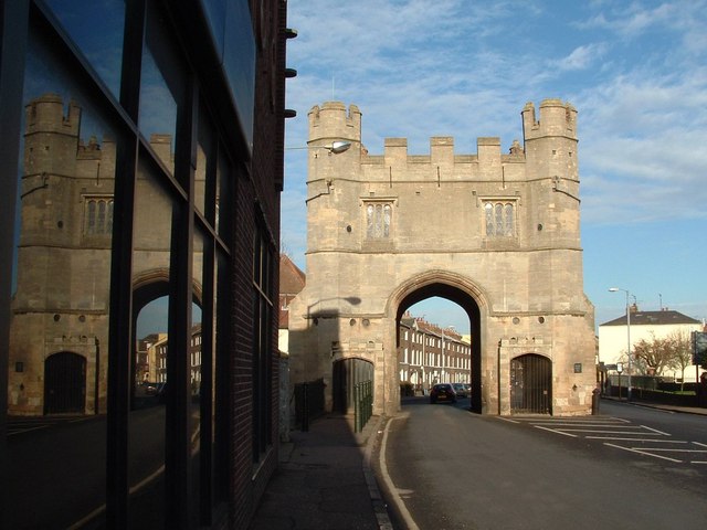
On your way through the town look out for the fine Custom House tourist information centre which was originally built in 1683. The St Nicholas's Chapel, built between 1145 and 1420, and the Burkitt Court Almshouses are other notable architectural highlights.
If you would like to extend your walking then there are several long distance trails running through the area. For example the Peter Scott Walk starts in King's Lynn. It will take you along the coastline of the Wash to Sir Peter Scott's lighthouse near Sutton Bridge.
The Nar Valley Way also starts in the town and will take you along the River Nar to Gressenhall.
A few miles to the north east of the town you can visit Roydon Common. Here you'll find nice trails taking you around a large area of heathland and woodland with Dartmoor Ponies to look out for. Just to the south of the common you can visit Bawsey Country Park.
King's Lynn and The Walks Ordnance Survey Map  - view and print off detailed OS map
King's Lynn and The Walks Open Street Map  - view and print off detailed map
*New* - Walks and Cycle Routes Near Me Map - Waymarked Routes and Mountain Bike Trails>>
King's Lynn and The Walks OS Map  - Mobile GPS OS Map with Location tracking
King's Lynn and The Walks Open Street Map  - Mobile GPS Map with Location tracking
Walks near King's Lynn
- Bawsey Pits - This country park near King's Lynn has nice trails to follow around around birch covered hills and a Scandinavian style lake
- Roydon Common - This lovely large area of heathland has some nice walking trails to try
- Peter Scott Walk - Travel along the Wash on this lovely, easy walk through Norfolk.
The path starts by the River Nene near to Naturalist and painter Sir Peter Scott's lighthouse - Fen Rivers Way - This is a teriffic riverside walking route running from Cambridge to King's Lynn in Norfolk
- Welney WWT - Enjoy waterside footpaths along the New Bedford River on this easy circular walk at the Welney Wetland Centre.
- Nar Valley Way - Follow the River Nar from King's Lynn to Gressenhall on this delightful waterside walk through Norfolk.
The walk passes Shouldham, West Acre and Litcham following footpaths and country lanes close to or beside the River Nar.
Walk highlights include Pentney Abbey, Pentney Lakes, West Acre Priory and Castle Acre castle and priory - Ouse Valley Way - Follow the River Great Ouse from the source at Brackley, Northamptonshire, to the mouth at The Wash at King's Lynn
- Nene Way - Follow the River Nene through the beautiful Nene Valley on this fabulous walk through Cambridgeshire, Lincolnshire and Northamptonshire.
The long distance path runs for over 100 miles, passing Northampton, Wellingborough, Oundle, Peterborough and Wisbech.
There's much to enjoy on the way with rushing weirs, a series of historic villages and old mills - Sandringham Country Park - This huge country park surrounds the Queen's splendid country retreat in Norfolk
- Castle Acre - This lovely circular walk takes you around the grounds of Castle Acre Priory, before heading along the River Nar to the nearby Castle Acre Common
- Dersingham Bog - This circular walk explores the Dersingham Bog Site of Special Scientific Interest in North Norfolk
- Great Massingham - This attractive Norfolk village includes a pretty pond, picturesque cottages, a village green and a fine old church.
Pubs/Cafes
Marriott's Warehouse is located in a fine spot on the quay. It's housed in a 16th-century warehouse and includes a cafe and a gallery. There's a good menu and quay-side outdoor tables for warmer days. You can also take in the stunning views across the river from the first-floor bar area. You can find it at South Quay with a postcode of PE30 5DT for your sat navs.
Dog Walking
The area is nice for a dog walk and Marriott's Warehouse mentioned above is also dog friendly inside and out.
Further Information and Other Local Ideas
One nice idea is to venture into neighbouring Cambridgeshire on foot while visiting two rivers and the coast on the way. You could follow the Peter Scott Walk north along the Ouse to The Wash and then head west along the coastal path to link with the River Nene. The waymarked Nene Way can then be followed south into Wisbech.
For more interesting local history head a couple of miles north east of the town to visit Castle Rising. Here you'll find the ruins of an English Heritage owned castle surrounded by impressive earthworks. The pretty little village of the same name is also well worth exploring. Just to the north of the village you'll also find Sandringham Country Park. The expansive park surrounds the Queen's famous country retreat. In the park you'll find miles of excellent woodland and parkland walking trails. On the western side of the estate there's also the interesting village of Wolferton. Here you can visit the noteworthy Wolferton Railway Station. The now disused station was well known during the 1800’s through its association with the Royal Family who used the station because of its proximity to Sandringham House. There are also trails to pick up around the Dersingham Bog Nature Reserve in this area. The reserve is part of the wider Sandringham Royal Estate and includes attractive heathland with interesting flora and fauna to see.
A few miles south east of the town is another of the historical highlights of the area at Castle Acre. Here you'll find the atmospheric ruins of and 11th century castle and priory. There's also some lovely waterside trails along the River Nar through the picture postcard village. The attractive village of Great Massingham and the historic Houghton Hall gardens are also located in this area.
A few miles to the south you will find Shouldham Warren where there are two colour coded waymarked walks. The nature reserve includes beautiful pine woodlands and a fine Rhododendron Avenue. The associated village is also worth a detour from the route with its pretty village green and 14th century church to see.
For more walking ideas around King's Lynn see the Norfolk Walks page.
Photos
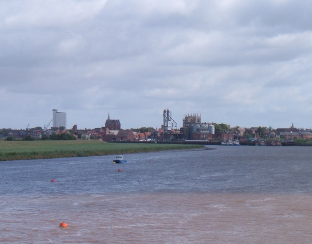
A view of the King's Lynn skyline, photographed from the distant Free Bridge as it crosses the River Great Ouse. King's Lynn's grain silo (the town's tallest building) can be clearly seen as can St Margaret's Church, the Old Granaries, St Nicholas Chapel spire and the old grain loading tower on Boal Quay.
East Quay and Great Ouse. Looking north towards the Wash - on a northerly bearing the next stop is the Arctic Circle


