Morwenstow Walk
![]()
![]() This walk explores the National Trust's Morwenstow on the Cornish coast near Bude.
This walk explores the National Trust's Morwenstow on the Cornish coast near Bude.
The area is great for cliff tops walks with some wonderful sea views to enjoy. There's also an interesting history with a thousand year old church, the 14th century farm and the driftwood built Hawker's Hut.
This circular walk starts at the car park near the to farm and takes you past the church to Henna Cliff. You can then follow a section of the South West Coast Path along the cliffs, heading south past Hawker's Hut and Cotton Beach. At Tidna Shute you head inland along The Tidna, before turning north to return to the car park.
If you'd like to extend the walk you could continue north along the coast path to the Welcombe and Marsland Valleys Nature Reserve and Hartland Quay in Devon. There's some wonderful rock formations, picturesque waterfalls, lots of sea birds and fine views to Lundy Island from here.
Heading south will take you to Bude where you can enjoy a stroll along the Bude Canal or visit the wildlife rich Bude Marshes.
Postcode
EX23 9SR - Please note: Postcode may be approximate for some rural locationsMorwenstow Ordnance Survey Map  - view and print off detailed OS map
Morwenstow Open Street Map  - view and print off detailed map
Morwenstow OS Map  - Mobile GPS OS Map with Location tracking
Morwenstow Open Street Map  - Mobile GPS Map with Location tracking
Pubs/Cafes
The delightful Rectory Tea Rooms are located at the start/end to the walk. It's housed in a marvellous 13th century building with antique furnishings, slate floors, open fires and original Oak Beams salvaged from the many ships wrecked along the North Cornwall coastline. They serve splendid homemade food with delicious Cornish cream teas a particular favourite. If you prefer a pub lunch then the 13th century Bush Inn is next door. Both establishments have a lovely garden area to sit out in on warmer days.
Dog Walking
The area is great for dog walking. The pub and tea rooms mentioned above are also dog friendly.
Further Information and Other Local Ideas
Just to the south you can pick up the Bude to Sandymouth Circular Walk. Sandy Mouth is a popular place to visit with a lovely National Trust beach, waterfalls and a nice cafe for refreshments.
If you follow the coast path south of Bude you can pick up the circular Crackington Haven Walk. It's another popular local area for walking with fine cliff top views and a nice beach. There's good facilities too with a car park and a beach-side pub with sea views. The walk also includes a visit to the historic Norman church at the little hamlet of St Gennys.
The village is at one end of the Tamara Coast To Coast Way. The 89 mile route runs from Cremyll in south Cornwall to Morwenstow on the northern coast.
Cycle Routes and Walking Routes Nearby
Photos
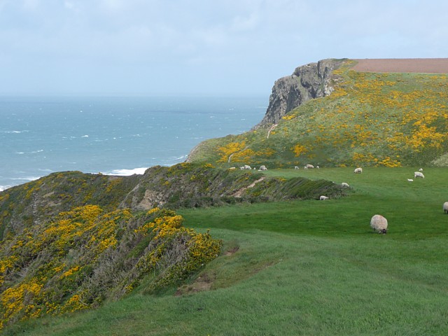
On Vicarage Cliff, Morwenstow The coastal path follows the cliff top over pasture, and then crosses a valley before climbing up to Henna Cliff (the top of which is in SS2015), which is stated to be 135m of sheer structureless conglomerate.
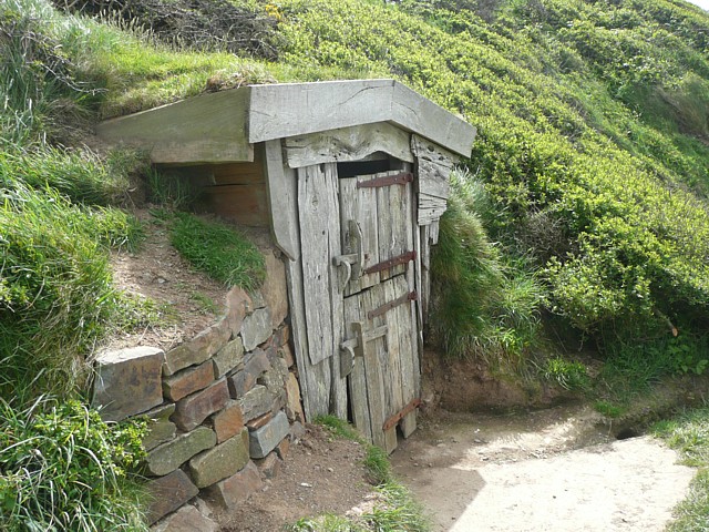
Hawker's Hut, Vicarage Cliff, Morwenstow Vicarage Cliff is 137m high, of sandstone and shales. Hawker's Hut (National Trust), built from driftwood, is on a ledge just below the cliff top, overlooking the sea. The Rev. Robert Stephen Hawker was vicar of Morwenstow from 1834 until his death in 1875. He was one of the best minor poets of the Victorian age, particularly as a ballad writer, e.g. 'The Song of the Western Men'. The 'Well of St. Morwenna' was also built by Hawker.
Cottage at Coombe, Morwenstow. This is a little hamlet of several cottages and a watermill, owned by the Landmark Trust and let to tourists.
The Old Vicarage. This was built by Robert Hawker, vicar from 1834 to 1875. The chimney-stacks are imitations of the towers of various churches and Oxford colleges that he had been connected with. He was a poet and wrote 'And shall Trelawney die' and the ballad 'The Song of the Western Men' that is almost the Cornish National Anthem.


