Newcastle Way
![]()
![]() Starting at Mow Cop, follow the Newcastle Way through Staffordshire to Market Drayton. You will pass through rough Moorland scenery around Mow Cop, rich farming country near Madeley before heading along the sandstone ridges of Maer and Ashley and then across the wide open spaces of Blore Heath to Almington.
Starting at Mow Cop, follow the Newcastle Way through Staffordshire to Market Drayton. You will pass through rough Moorland scenery around Mow Cop, rich farming country near Madeley before heading along the sandstone ridges of Maer and Ashley and then across the wide open spaces of Blore Heath to Almington.
There are some challenging climbs with views to the west of the Shropshire Hills and south as far as Cannock Chase.
Highlights on the way include visits to Silverdale Country Park and Apedale Country Park near the attractive market town of Newcastle Under Lyme.
Newcastle Way Ordnance Survey Map  - view and print off detailed OS map
Newcastle Way Open Street Map  - view and print off detailed map
Newcastle Way OS Map  - Mobile GPS OS Map with Location tracking
Newcastle Way Open Street Map  - Mobile GPS Map with Location tracking
Further Information and Other Local Ideas
Just off the route near Newcastle Under Lyme you'll find the village of Keele. Here you can explore the lovely campus of Keele University which includes an arboretum, lakes and gardens. It's well laid out with several colour coded footpaths to try.
For more walking ideas in the area see the Staffordshire Walks page.
Cycle Routes and Walking Routes Nearby
Photos

Newcastle Way at Apedale Country Park

Newcastle Way Marker Post. At the entrance to Apedale Country Park this post marks part of the route of the Newcastle Way a 25 mile walking route through much of the Borough of Newcastle under-Lyme linking the Staffordshire Way at Mow Cop in the north with the Shropshire Union Canal towpath at Market Drayton in the south.

The waymark for this footpath sits slightly uneasily on a small traffic island.

Mow Cop

Apedale Country Park near Newcastle under Lyme. Pit head wheel and coal tub memorial to the miners of North Staffordshire.

Lakes near Black Bank. A couple of quite deep lakes/pools in the Silverdale Void or more correctly High Lane Void, Silverdale, the site of old opencast coal workings associated with Silverdale Colliery. Silverdale was closed in 1998, the last colliery in this area to go.
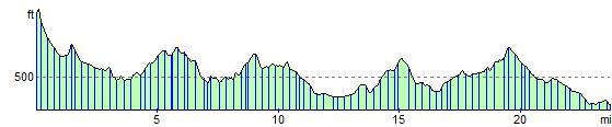
Elevation Profile