Plumpton Walks
![]()
![]() This East Sussex based village is located near Lewes on the edge of the South Downs. There's some excellent elevated walks along the Downs with a popular local nature reserve and viewpoint withing walking distance. The area is also known for its race course and Plumpton College, an institution which farms over 2500 acres of land and has become one of the leading centres for land-based education in the UK.
This East Sussex based village is located near Lewes on the edge of the South Downs. There's some excellent elevated walks along the Downs with a popular local nature reserve and viewpoint withing walking distance. The area is also known for its race course and Plumpton College, an institution which farms over 2500 acres of land and has become one of the leading centres for land-based education in the UK.
This circular walk from the village visits some of the highlights of the area including Plumpton Palace, Ditchling Beacon, the Clayton Windmills, Ditchling village, Stoneywish Country Park and the neighbouring village of East Chiltington.
The walk starts in the village though you could also start from Plumpton Station. The station is located just north of the route at Plumpton Green.
From the village it is a short stroll west to Plumpton Place where you'll find a Grade II* listed Elizabethan manor house. The route then heads south past Plumpton Bostall to join with The South Downs Way on Plumpton Plain. You can follow the waymarked trail west past Streat Hill to the Ditchling Beacon Nature Reserve. The reserve includes lovely chalk grassland which is covered in wildflowers and butterflies in the summer months.
The route then continues west to visit the Clayton Windmills. Known locally as Jack and Jill, the site includes a Grade II listed post mill and a tower mill.
You then head east to Burnhouse Bostall where you can pick up a section of the Sussex Border Path. Follow the trail north and it will take you into Ditchling village. From here you head east through Stoneywish Country Park to Hayleigh Farm, Streat Place, Plumpton Racecourse and East Chiltington. From here you head south past Novington Manor to return to Plumpton.
Plumpton Ordnance Survey Map  - view and print off detailed OS map
Plumpton Open Street Map  - view and print off detailed map
Plumpton OS Map  - Mobile GPS OS Map with Location tracking
Plumpton Open Street Map  - Mobile GPS Map with Location tracking
Pubs/Cafes
Back in the village head to the Half Moon Inn for some post walk refreshments. The former 19th century coaching house serves high quality food including an excellent Sunday roast. There's ample parking and a lovely garden for summer days. You can find them on Ditchling Road with a postcode of BN7 3AF for your sat navs.
Dog Walking
The country trails on the Downs are ideal for fit dogs. The Half Moon Inn mentioned above is also dog friendly.
Further Information and Other Local Ideas
If you continue west along The South Downs Way you could visit one of the major highlights of the area at the Devils Dyke.
If you head south east towards Lewes you can pick up the Lewes to Alfriston Walk or the Lewes to Eastbourne Walk and head to the coast.
Just a couple of miles to the south of Lewes you'll find the interesting village of Iford. The historic settlement includes 18 listed buildings, a 12th century church and a sundial marking the Greenwich meridian which runs through the village. From here you can enjoy a walk up to the viewpoint at Iford Hill on a particularly lovely section of the South Downs. On the Iford walk there's also Rodmell where you can visit the National Trust's Monk's House. The 16th-century weatherboarded cottage was once the home of author Virginia Woolfe and her husband. Next to the village there's also the Castle Hill National Nature Reserve. The significant site includes chalk grassland with ancient settlements and lots of interesting flora and fauna to see.
The Falmer to Lewes Walk starts from nearby Falmer and will take you up to the lovely ridge top walk at Blackcap which lies just south of the village. There's some fascinating ancient sites, pretty wildflowers, a variety of butterflies and tremendous views over the Weald from here. Falmer itself is also very attractive with its 17th century church, large pond and green which is ideal for picnics.
For more walking ideas in the area see the South Downs Walks page.
Cycle Routes and Walking Routes Nearby
Photos
Plumpton College. The building in view dates from 1926 though the country council had originally purchased the surrounding estate in 1919 to provide education for those entering into agriculture. It grew in size but was closed during the Second World War when it was given over to training land girls before reopening after the conflict. Viewed from Ditchling Road the field in the foreground is called Upper Church Laine.
Plumpton Place. The original house dates back to the 16th century and had fallen into disrepair by the 20th century. The then owner of Country Life magazine, Edward Hudson, commissioned Sir Edward Lutyens in 1927 to refurbish the property that restored the façade of the original building with added extras. Lutyens also designed the grounds enclosing the building within a series of lakes accessible only by a bridge. The building is currently owned by an American Tom Perkins who was briefly married to author Danielle Steel. Up until 1985 it was the home of former Led Zeppelin guitarist Jimmy Page.
Plumpton Plain. Viewed from the South Downs Way. The wooded hill in the distance is Great Wood next to Stanmer Park whilst beyond the high rise buildings of Brighton can just be made out.
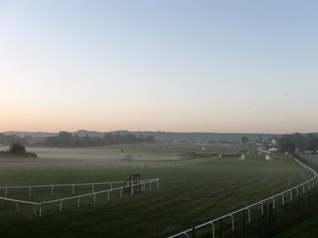
Plumpton Racecourse. Viewed from the footbridge over the railway. The course was opened in 1884 on farmland formerly owned by nearby Ashurst Farm utilising the recently opened Plumpton station. The steeplechases were introduced in 1892. An early morning mist envelopes the northern part of the course but thins out towards the southern end where the northern scarp slope of the South Downs can be seen on the horizon.
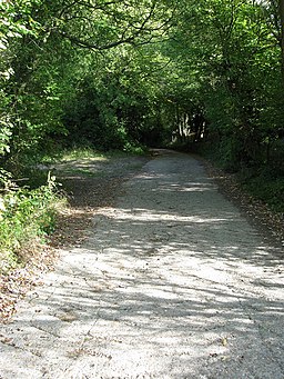
View of Plumpton Bostall. Bostall is an old Sussex word for a track that heads up the northern scarp slope of the South Downs and was used for sheep droving between the pastures above and the fields and farms below. Many of the routes have become tracks now used as bridleways or footpaths, though a few have been surfaced and become part of the road network. Plumpton Bostall was little more than a bridleway until World War Two when the need to get the tanks and artillery up onto the training grounds on the Downs meant a concrete surface was applied and has remained in place ever since. The track is currently used as vehicular access to Streathill Farm from the B2116. A bridleway heads off to the left towards Plumpton Place.
Jack & Jill the Clayton windmills. Viewed from the car park as the sun sets beyond the Downs. Jack is in the background and was originally known as Dunction Mill. It was built in 1866 to replace an older post mill erected in 1765 the roundhouse of which still survives next to the current mill. It continued milling until 1906 when it went out of business and stood idle for a couple of years until it was purchased as a private residence which it remains today. Jill is the post mill in the foreground and is actually the older of the two having been built in 1821 in Dyke Road in Brighton. Known as Lashmars mill it was purchased by the then owner of Jack in 1852 to increase his milling production. The windmill was dismantled, moved by oxen and reassembled on the site. It stopped working in 1906. Since 1978 it has been restored by a team volunteers and is open to the public most weekends from May to September.


