Settle Caves and Waterfalls Walk
![]()
![]() This beautiful circuit around Settle visits a series of rushing waterfalls, pretty becks, limestone outcrops and mysterious caves. The walk runs for about 9 miles with some moderate climbing on the opening section before descending back to the town on the second section.
This beautiful circuit around Settle visits a series of rushing waterfalls, pretty becks, limestone outcrops and mysterious caves. The walk runs for about 9 miles with some moderate climbing on the opening section before descending back to the town on the second section.
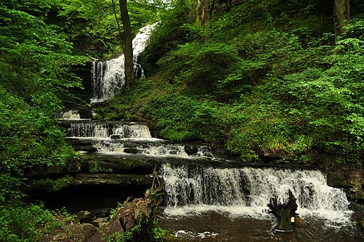
The walk starts from the train station in Settle and heads north east, passing the Castlebergh woodland and Barrel Sykes. Follow the footpaths past Langcliffe and then up to Winskill Stones where you will find a 74-acre area of limestone grassland and limestone pavement. From here it is a short walk to Catrigg Force. The picturesque falls have 2 main drops of about 20 feet and a series of smaller waterfalls. It's a delightful area, with peaceful woodland and the Stainforth Beck to see.
After enjoying the falls you head south east past the Winskill Stones to the caves. You'll pass Jubilee Cave, Victoria Cave and Attermire Cave. The Victoria Cave contained fossil remains, including mammoth, straight-tusked elephant, cave bear and hippopotamus, Bos primigenius, Rhinoceros leptorhinus and spotted hyenas.
The route then continues south, passing Sugar Loaf Hill before turning down High Hill Lane to reach Scaleber Force. The falls are in another lovely location with the water cascading down several levels to the deep pool below.
The walk then heads north west, passing Springfield and Upper Settle before returning to the train station.
To further explore the countryside surrounding the town you could try the Settle Loop long distance trail. At Catrigg Force you are close to the village of Stainforth where you can also visit the lovely Stainforth Force on the Settle Riverside Walk.
Settle Caves and Waterfalls Walk Ordnance Survey Map  - view and print off detailed OS map
Settle Caves and Waterfalls Walk Open Street Map  - view and print off detailed map
*New* - Walks and Cycle Routes Near Me Map - Waymarked Routes and Mountain Bike Trails>>
Settle Caves and Waterfalls Walk OS Map  - Mobile GPS OS Map with Location tracking
Settle Caves and Waterfalls Walk Open Street Map  - Mobile GPS Map with Location tracking
Pubs/Cafes
The Golden Lion in Settle is a good choice for some refreshments after your exercise. They do very good food and have a sun trap garden to relax in on warmer days. Inside there's a cosy, warming atmosphere and they also provide good quality accommodation if you need to stay over. You can find the 17th century inn on Duke Street at a postcode of BD24 9DU for your sat navs. The inn is also very dog friendly if you have your canine friend with you.
Further Information and Other Local Ideas
On the other side of the river you'll find the nearby village of Giggleswick. Here you could pick up the circular Giggleswick Walk and enjoy a climb to the excellent viewpoints on Giggleswick Scar.
To the south is the worthy village of Long Preston with its village green and 18th century pub to visit.
To the south east there's Kingsdale where you can visit the impressive Yordas Cave. You can explore the cave which includes a large main chamber with a waterfall and a stream running through it.
For more walking ideas in the area see the Yorkshire Dales Walks page.


