Tees Link - Guisborough to Middlesbrough
![]()
![]() Travel from Guisborough to Middlesbrough on this route which links the Teesdale Way and the Cleveland Way. The walk passes through Hutton Low Cross Woods, Pinchinthorpe and Flatts Lane Country Park before the final section takes you through Middlesbrough to the finish point on the River Tees.
Travel from Guisborough to Middlesbrough on this route which links the Teesdale Way and the Cleveland Way. The walk passes through Hutton Low Cross Woods, Pinchinthorpe and Flatts Lane Country Park before the final section takes you through Middlesbrough to the finish point on the River Tees.
There's much to enjoy with some lovely North York Moors scenery at the start of the route including great views of the popular Roseberry Topping Hill. You'll also pass the Guisborough Forest and Walkway where there's cycle trails, walking routes, bridleways, a trim trail and an easier sculpture trail.
Tees Link Ordnance Survey Map  - view and print off detailed OS map
Tees Link Open Street Map  - view and print off detailed map
Tees Link OS Map  - Mobile GPS OS Map with Location tracking
Tees Link Open Street Map  - Mobile GPS Map with Location tracking
Further Information and Other Local Ideas
The Cleveland Street Walk can be picked up in Guisborough at the historic priory ruins. The photogenic ruins are run by English Heritage and are well worth a visit.
For more walking ideas in the area see the North York Moors Walks page.
Cycle Routes and Walking Routes Nearby
Photos

Highcliff Nab, Guisborough Forest, near the start. A dominant crag overlooking Guisborough, it has until recently become smothered in forestry. Recent felling has now opened up the Nab to its former glory.

Forest Track and Gate, Hutton Lowcross

Pinchinthorpe Visitor Centre. An old railway carriage has recently been installed at the centre with the intention I think of converting it into a classroom.

Nature Pond, Flatts Lane Country Park. The sign says look out for newts and wild irises.

The trail at this point descends Green Hill through Kemplah Woods to Guisborough. In the very far distance is the North Sea.

Dropping down to the Cross Keys with Roseberry Topping (NZ5712) in the distance.

The Tees Link Footpath follows the route of the mineral railway which served Normanby Brickworks.

Field of snow near Highcliff Wood. This picture was taken from the Cleveland Way long-distance footpath as it approaches its junction with the Tees Link footpath. In the distance a part of Highcliff Wood can be seen on the horizon. Highcliff Nab lies just behind the trees on the left-hand side of the picture.
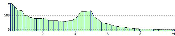
Elevation Profile