Walks in Middlesbrough
![]()
![]() This large town in Yorkshire has a number of fine walks to try in the town and through the surrounding area. There's a number of attractive parks, river walks along the Tees and several interesting historical sites to visit.
This large town in Yorkshire has a number of fine walks to try in the town and through the surrounding area. There's a number of attractive parks, river walks along the Tees and several interesting historical sites to visit.
This walk heads south through the town to visit Normanby Hall, Flatts Lane Country Park and Ormesby Hall.
The walk starts at Middlesbrough Dock on the River Tees, just to the east of the train station. Here you can pick up the Tees Link and follow the waymarked footpath south east past the Riverside Stadium, home to Middlesbrough F.C. It will take you past North Ormesby, Brambles Farm and Teesville. Here you can follow the Spencer Beck to Normanby Hall.
The trail continues to Flatts Lane Park where there are miles of nice woodland trails to try. There are also fine views over the Eston Hills and the North York Moors from the elevated position of the park. Here you could take a detour from the route and head north across Eston Moor to visit Eston Nab. It's another fine viewpoint on the edge of the town.
After exploring the park the route then heads through Ormesby to visit Ormesby Hall. This National Trust owned hall is a Grade I listed building, described as a classic Georgian Mansion built in the Palladian style. There's 250 acres of parkland and farmland to explore on a network of footpaths. You can extend the walk here by heading a short distance west to visit Stewart Park where there's more nice trails and a museum.
After exploring the hall the route then follows a shared cycling and walking trail north to Pallister before heading east to pick up the Tees Link. You can then follow this back to the river and the finish point back at the dock.
Middlesbrough Ordnance Survey Map  - view and print off detailed OS map
Middlesbrough Open Street Map  - view and print off detailed map
Middlesbrough OS Map  - Mobile GPS OS Map with Location tracking
Middlesbrough Open Street Map  - Mobile GPS Map with Location tracking
Walks near Middlesbrough
- Stokesley - This attractive market town is located in a fine position in the North York Moors National Park
- Cleveland Way - This wonderful trail runs from Helmsley to Filey, taking you through the beautiful North York Moors national park, atop the Hambleton Hills ridge and along the stunning North Yorkshire coastline.
The trail begins in Helmsley, with the first section taking you through the heather moorland of the North York Moors, passing the village of Osmotherley, the pretty Cod Beck Reservoir and the ancient stones at Lord Stones Country Park and the Wainstones.
After enjoying the fabulous views on the elevated moors you arrive at Saltburn to begin the coastal stretch - Osmotherley - The North Yorkshire village of Osmotherley is situated on the western edge of the North York Moors National Park in the Hambleton Hills
- Cod Beck Reservoir - Enjoy a short walk around this pretty reservoir on the western edge of the North York Moors
- Hambleton Hills - This walk explores the Hambleton Hills range on the western edge of the North York Moors
- Lyke Wake Walk - The Lyke Wake Walk is a complete crossing of the North Yorkshire Moors from west to east
- Lord Stones - Visit this ancient stone and enjoy fabulous views from Cringle Moor on this exhilirating circular walk on the North York Moors
- Wainstones - Climb Hasty Bank Hill and visit the fascinating Wainstones on this circular walk in the North York Moors
- Silton Forest - Enjoy miles of mountain bike trails and footpaths in this large coniferous forest on the North York Moors
- Cleveland Way Circular Walk - Great Ayton - This lovely circular walk from Great Ayton uses public footpaths and a section of the Cleveland Way to take you to two of the highlights of the area
- Captain Cook's Monument - Enjoy a walk from Great Ayton to this iconic landmark on Easby Moor
- Roseberry Topping - Climb to the summit of this distinctive hill near Guisborough and enjoy wonderful views across the beautiful North York Moors National Park
- Normanby Hall Country Park - Explore the three hundred acres of parkland and woodland surrounding the 19th century Normanby Hall
- Flatts Lane Country Park - This 100 acre country park in Normanby has super views of the Eston Hills and the North York Moors
- Tees Link - Travel from Guisborough to Middlesbrough on this route which links the Teesdale Way and the Cleveland Way
- Eston Nab - Climb to Eston Nab and Eston Beacon on this popular walk in North Yorkshire
Further Information and Other Local Ideas
Just to the south west of the dock you'll find the pretty Albert Park. It's a nice place for a stroll in the town, with a surfaced footpaths taking you to gardens, large lake, a fountain and a bandstand. Just to the west of Ormesby Hall there's also Stewart Park. There's 120 acres of parkland here with mature woodland, an arboretum and lakes with wildfowl. The park also includes the Captain Cook Birthplace Museum where you can learn about the history of British naval explorer and circumnavigator Captain James Cook. The explorer achieved the first recorded European contact with the eastern coastline of Australia and the Hawaiian Islands, and the first recorded circumnavigation of New Zealand.
Photos
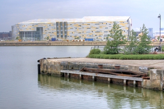
Entrance to Middlesbrough Docks. On the far side the new Middlesbrough College is almost complete, the first students arriving in a couple of months. Nearer to the camera one of the old lock gates is permanently in an open position.
View From the Bandstand to the Central Fountain. Albert Park was donated to Middlesbrough by the Ironmaster Henry Bolchow. It was opened on 11th August 1868 by Prince Arthur Duke of Connaught the youngest son of Queen Victoria. The park was named after Prince Albert the late husband of the Queen. It was designed by William Barratt and since 2000 has undergone a multi million pound restoration including the fountain and the recreation of this bandstand.
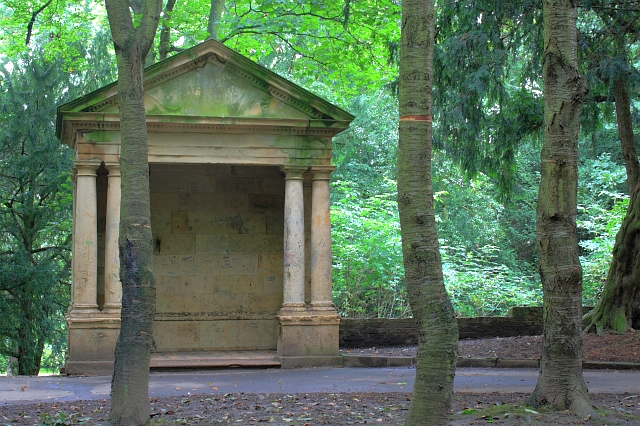
Folly Temple, Stewart Park. A garden folly once part of the Marton Hall estate built by Teesside industrialist Henry Bolckow in 1858. In 1878 the estate passed to Bolckow's nephew Carl who managed to continue to lead an extravagant lifestyle despite the boom years of the iron industry being over. By 1907 the hall was empty, all fixtures being sold to pay off his debts. Apart from the billeting of troops during WW1 it was never lived in again. The estate was brought in 1925 by Thomas J Stewart who presented it to Middlesbrough as a park. The hall itself destroyed by fire in 1960. A few stoneworks remain.


